Southam is a market town and civil parish in the Stratford-on-Avon district of Warwickshire, England. Southam is situated on the River Stowe, which flows from Napton-on-the-Hill and joins Warwickshire's River Itchen at Stoneythorpe, just outside the town.

Warwick is a market town, civil parish and the county town of Warwickshire in the Warwick District in England, adjacent to the River Avon. It is 9 miles (14 km) south of Coventry, and 19 miles (31 km) south-east of Birmingham. It is adjoined with Leamington Spa and Whitnash.

Pembridge is a village and civil parish in the Arrow valley in Herefordshire, England. The village is on the A44 road about 6 miles (10 km) east of Kington and 7 miles (11 km) west of Leominster. The civil parish includes the hamlets of Bearwood, Lower Bearwood, Lower Broxwood, Marston, Moorcot and Weston. The 2011 Census recorded the parish population as 1,056.
Bordesley is an area of Birmingham, England, 1.2 miles (2 km) south east of the city centre straddling the Watery Lane Middleway ring road. It should not be confused with nearby Bordesley Green. Commercial premises dominate to the west of the ring road, but much of this area is to be redeveloped. Blocks of residential apartments are planned and set for completion from the mid-2020s onwards. The largely residential area east of the ring road was renamed Bordesley Village following large scale clearance of back-to-back houses and redevelopment in the 1980s and 90s. Bordesley is the real life setting of the BBC series Peaky Blinders, and home to Birmingham City Football Club's ground, St Andrew's.

Cheylesmore is a suburb in the southern half of the city of Coventry, West Midlands, England. It is one of Coventry's largest suburbs, sharing borders with Whitley and Stivichall in the South, extending into Coventry city centre and bordering with Earlsdon in the North. Locally pronounced as 'Charlesmore' or occasionally 'Chellsmore', Cheylesmore has two shopping parades situated in Daventry Road and Quinton Park. These shops overlook a small park and pool known as Quinton Pool. It takes its name from Cheylesmore Manor. The original name probably derives from 'Chez Les Morts' since a huge plague pit was found during excavations after the Second World War. The city gate leading to the area was labelled as Childsmore Gate on old maps, an alternative etymology of the name.

Packwood House is a timber-framed Tudor manor house in Packwood on the Solihull border near Lapworth, Warwickshire. Owned by the National Trust since 1941, the house is a Grade I listed building. It has a wealth of tapestries and fine furniture, and is known for the garden of yews.
The River Sherbourne is a river that flows under the centre of the city of Coventry, in the West Midlands, in England.

Stivichall or Styvechale is a suburb of the city of Coventry, West Midlands, England. It is a mainly residential area in the south of the city.

Clayton Hall is a 15th-century manor house on Ashton New Road in Clayton, Manchester, England, hidden behind trees in a small park. The hall is a Grade II* listed building, the mound on which it is built is a scheduled ancient monument, and a rare example of a medieval moated site. The hall is surrounded by a moat, making an island 66 by 74 metres. Alterations were made to the hall in the 16th and 17th centuries, and it was enlarged in the 18th century.

The buildings known as Whitefriars are the surviving fragments of a Carmelite friary founded in 1342 in Coventry, England. All that remains are the eastern cloister walk, a postern gateway in Much Park Street and the foundations of the friary church. It was initially home to a friary until the dissolution of the monasteries. During the 16th century it was owned by John Hales and served as King Henry VIII School, Coventry, before the school moved to St John's Hospital, Coventry. It was home to a workhouse during the 19th century. The buildings are currently used by Herbert Art Gallery and Museum, Coventry.

Hay Hall is a former 15th century hall located at Tyseley, in Birmingham, West Midlands, England. The extensive Hay Hall estate was situated between the Coventry and Warwick roads and included an area now known as Hay Mills, which was the site of a water mill. In the 16th century the timber-framed building was encased in brick. Originally a sub manor of the Este family, the building form comprised a central open hall with cross-wings at either end. There are no traces of the original moat in the area, with the modern surroundings currently developed as factories and works, known as Hay Hall Business Park. It was listed Grade II in 1952.
Spon Street is an historic street in central Coventry, in the West Midlands of England. The street was once part of a route that ran from Gosford to Birmingham – a route which remained intact until the 1960s. During the construction of Coventry's Inner Ring Road, built to relieve traffic on the narrow city centre streets, Spon Street was cut in half and the route severed.
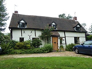
Dormer Cottage is a Grade II listed building on Washbrook Lane, in the Allesley area of the City of Coventry, in the West Midlands of England. The house was probably constructed in the mid-17th century and extended in the 20th century.

All Saints Church is a mediaeval church in the suburban village of Allesley adjoining the City of Coventry, in the West Midlands of England. The building is grade I listed, though churches in ecclesiastical use are exempt from listed building procedures.
There are 24 Grade II* listed buildings in the City of Coventry. In the United Kingdom, a listed building is a building or structure of special historical or architectural importance. These buildings are legally protected from demolition, as well as from any extensions or alterations that would adversely affect the building's character or destroy historic features. Listed buildings are divided into three categories—Grade I buildings are buildings of "exceptional" interest, Grade II buildings are buildings of special interest, and Grade II* buildings are Grade II buildings that are of particular interest. Coventry is an ancient city and a metropolitan borough in the West Midlands of England. The city's history dates back to at least the 11th century (CE), and it was a thriving centre of commerce in mediaeval times.
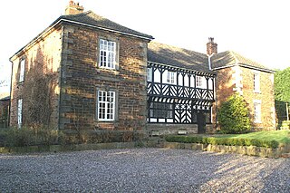
Mawdesley Hall is a country manor in Hall Lane, Mawdesley, Chorley, Lancashire, England. It consists of a central hall with two cross-wings. The central hall was built in the 17th century, its lower storey being timber-framed and its upper floor plastered and painted to resemble timber-framing. The cross-wings were added in the late 18th or early 19th century. The west wing is in sandstone, and the east wing is in brick with stone dressings. The hall is recorded in the National Heritage List for England as a designated Grade I listed building.

St Laurence's is the Church of England parish church of Foleshill, Coventry. It is a Grade II* listed building with features, including the tower, from the 15th century. It is located on Old Church Road (B4082) to the north-east of Coventry city centre.
Highlow is a civil parish within the Derbyshire Dales district, in the county of Derbyshire, England. Largely rural, Highlow's population is reported with the population of neighbouring parishes for a total of 585 residents in 2011. It is 140 miles (230 km) north-west of London, 28 miles (45 km) north-west of the county city of Derby, and 7+1⁄2 miles (12.1 km) north of the nearest market town of Bakewell. Highlow is wholly within the Peak District national park, and shares a border with the parishes of Abney and Abney Grange, Eyam, Foolow, Grindleford, Hathersage as well as Offerton. There are nine listed buildings in Highlow.

Trinity House was a small country house in the village of Allesley, Coventry in the West Midlands, formerly the county of Warwickshire. It stood at the end of Rectory Lane immediately north-west of All Saints Church on the crest of the hill between the River Sherbourne and Pickford Brook. The house became one of "the lost houses" of England after being demolished in the mid-1960s as part of the wider destruction of country houses in 20th-century Britain.

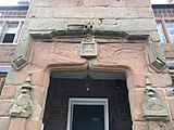
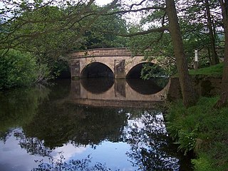
Mile Lane Bridge is a road-over-rail bridge in Coventry, central England. It is possibly the first use of a flying arch over a railway cutting and is a Grade II listed building.