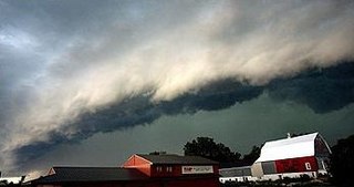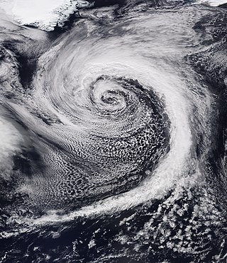
In meteorology, a cyclone is a large air mass that rotates around a strong center of low atmospheric pressure, counterclockwise in the Northern Hemisphere and clockwise in the Southern Hemisphere as viewed from above. Cyclones are characterized by inward-spiraling winds that rotate about a zone of low pressure. The largest low-pressure systems are polar vortices and extratropical cyclones of the largest scale. Warm-core cyclones such as tropical cyclones and subtropical cyclones also lie within the synoptic scale. Mesocyclones, tornadoes, and dust devils lie within the smaller mesoscale.

A subtropical cyclone is a weather system that has some characteristics of both tropical and extratropical cyclones.

A nor'easter, is a large-scale extratropical cyclone in the western North Atlantic Ocean. The name derives from the direction of the winds that blow from the northeast. The term is commonly used in the winter in New England and Atlantic Canada.

The Intertropical Convergence Zone, known by sailors as the doldrums or the calms because of its monotonous windless weather, is the area where the northeast and the southeast trade winds converge. It encircles Earth near the thermal equator though its specific position varies seasonally. When it lies near the geographic Equator, it is called the near-equatorial trough. Where the ITCZ is drawn into and merges with a monsoonal circulation, it is sometimes referred to as a monsoon trough.

A storm surge, storm flood, tidal surge, or storm tide is a coastal flood or tsunami-like phenomenon of rising water commonly associated with low-pressure weather systems, such as cyclones. It is measured as the rise in water level above the normal tidal level, and does not include waves.

In meteorology, a low-pressure area, low area or low is a region where the atmospheric pressure is lower than that of surrounding locations. Low-pressure areas are commonly associated with inclement weather, while high-pressure areas are associated with lighter winds and clear skies. Winds circle anti-clockwise around lows in the northern hemisphere, and clockwise in the southern hemisphere, due to opposing Coriolis forces. Low-pressure systems form under areas of wind divergence that occur in the upper levels of the atmosphere (aloft). The formation process of a low-pressure area is known as cyclogenesis. In meteorology, atmospheric divergence aloft occurs in two kinds of places:

The westerlies, anti-trades, or prevailing westerlies, are prevailing winds from the west toward the east in the middle latitudes between 30 and 60 degrees latitude. They originate from the high-pressure areas in the horse latitudes and trend towards the poles and steer extratropical cyclones in this general manner. Tropical cyclones which cross the subtropical ridge axis into the westerlies recurve due to the increased westerly flow. The winds are predominantly from the southwest in the Northern Hemisphere and from the northwest in the Southern Hemisphere.

A mesoscale convective system (MCS) is a complex of thunderstorms that becomes organized on a scale larger than the individual thunderstorms but smaller than extratropical cyclones, and normally persists for several hours or more. A mesoscale convective system's overall cloud and precipitation pattern may be round or linear in shape, and include weather systems such as tropical cyclones, squall lines, lake-effect snow events, polar lows, and mesoscale convective complexes (MCCs), and generally forms near weather fronts. The type that forms during the warm season over land has been noted across North and South America, Europe, and Asia, with a maximum in activity noted during the late afternoon and evening hours.

The 1975 Pacific typhoon season was one of the deadliest tropical cyclone seasons on record, with nearly 229,000 fatalities occurring during the season. It had no official bounds; it ran year-round in 1975, but most tropical cyclones tend to form in the northwestern Pacific Ocean between June and December. These dates conventionally delimit the period of each year when most tropical cyclones form in the northwestern Pacific Ocean.

An Atlantic hurricane is a type of tropical cyclone that forms in the Atlantic Ocean primarily between June and November. The terms "hurricane", "typhoon", and "cyclone" can be used interchangeably to describe this weather phenomenon. These storms are rotating, organized systems of clouds and thunderstorms that originate over tropical or subtropical waters and have closed low-level circulation, not to be confused with tornadoes. They form over low pressure systems. In the North Atlantic, central North Pacific, and eastern North Pacific, the term "hurricane" is mainly used, whereas "typhoon" is more commonly used for storms originating in the western North Pacific. The term "cyclone" is used in the South Pacific and Indian Ocean.

Tropical cyclogenesis is the development and strengthening of a tropical cyclone in the atmosphere. The mechanisms through which tropical cyclogenesis occurs are distinctly different from those through which temperate cyclogenesis occurs. Tropical cyclogenesis involves the development of a warm-core cyclone, due to significant convection in a favorable atmospheric environment.

Extratropical cyclones, sometimes called mid-latitude cyclones or wave cyclones, are low-pressure areas which, along with the anticyclones of high-pressure areas, drive the weather over much of the Earth. Extratropical cyclones are capable of producing anything from cloudiness and mild showers to severe gales, thunderstorms, blizzards, and tornadoes. These types of cyclones are defined as large scale (synoptic) low pressure weather systems that occur in the middle latitudes of the Earth. In contrast with tropical cyclones, extratropical cyclones produce rapid changes in temperature and dew point along broad lines, called weather fronts, about the center of the cyclone.

A tropical cyclone is a rapidly rotating storm system with a low-pressure center, a closed low-level atmospheric circulation, strong winds, and a spiral arrangement of thunderstorms that produce heavy rain and squalls. Depending on its location and strength, a tropical cyclone is called a hurricane, typhoon, tropical storm, cyclonic storm, tropical depression, or simply cyclone. A hurricane is a strong tropical cyclone that occurs in the Atlantic Ocean or northeastern Pacific Ocean, and a typhoon occurs in the northwestern Pacific Ocean. In the Indian Ocean and South Pacific, comparable storms are referred to as "tropical cyclones". In modern times, on average around 80 to 90 named tropical cyclones form each year around the world, over half of which develop hurricane-force winds of 65 kn or more. Tropical cyclones carry heat away from the tropics and transport it towards temperate latitudes. This plays an important role in regulating global climate. Tropical cyclones can be very harmful for people.

The 2002–03 South Pacific cyclone season was the most active and longest tropical cyclone season since 1997–98, with ten tropical cyclones occurring within the South Pacific basin between 160°E and 120°W. The season started earlier than normal, with two systems developing before the official start of the season on November 1, 2002, while the final system dissipated on June 9, 2003, after the season had officially ended on April 30. During the season, tropical cyclones were officially monitored by the Regional Specialized Meteorological Centre (RSMC) in Nadi, Fiji and the Tropical Cyclone Warning Centres in Brisbane, Australia and Wellington, New Zealand. The United States Armed Forces through the Joint Typhoon Warning Center (JTWC), also monitored the basin and issued unofficial warnings for American interests. RSMC Nadi attaches a number and an F suffix to tropical disturbances that occur within the basin, while the JTWC designates significant tropical cyclones with a number and a P suffix. RSMC Nadi, TCWC Wellington and TCWC Brisbane all use the Australian Tropical Cyclone Intensity Scale and estimate windspeeds over a ten-minute period, while the JTWC estimates sustained winds over a one-minute period, which are subsequently compared to the Saffir–Simpson Hurricane Scale (SSHS).

The Aleutian Low is a semi-permanent low-pressure system located near the Aleutian Islands in the Bering Sea during the Northern Hemisphere winter. It is a climatic feature centered near the Aleutian Islands measured based on mean sea-level pressure. It is one of the largest atmospheric circulation patterns in the Northern Hemisphere and represents one of the "main centers of action in atmospheric circulation."
The following outline is provided as an overview of and topical guide to tropical cyclones:

The following is a glossary of tropical cyclone terms.

Paleotempestology is the study of past tropical cyclone activity by means of geological proxies as well as historical documentary records. The term was coined by American meteorologist Kerry Emanuel.


