Alblasserdam is a town and municipality in the western Netherlands, in the province of South Holland. It covers an area of 10.06 km2 (3.88 sq mi), of which 1.27 km2 (0.49 sq mi) is water, and has a population of 20,002 as of 2017. Alblasserdam is officially a part of the Drechtsteden region. A portion of the small village of Kinderdijk, which boasts the largest and most famous concentration of windmills in the Netherlands, is part of Alblasserdam.
Capelle aan den IJssel[kaːˈpɛlə ʔaːn dɛn ˈɛisəl](listen) is a town and municipality in the western Netherlands, in the province of South Holland. The municipality had a population of 66,712 in 2017, and covers an area of 15.40 km2 (5.95 sq mi), of which 1.15 km2 (0.44 sq mi) is water. It is situated on the eastern edge of Rotterdam, on the Hollandse IJssel river.
Krimpen aan den IJssel is a town and municipality in the western Netherlands, in the province of South Holland. The municipality had a population of 29,120 in 2017, and covers an area of 8.95 km2 (3.46 sq mi) of which 1.15 km2 (0.44 sq mi) is water.

Nieuwerkerk aan den IJssel is a town and former municipality in the western Netherlands, in the province of South Holland. Since 2010 it is part of the new municipality of Zuidplas.
Ridderkerk is a town and municipality in the western Netherlands, in the province of South Holland. The municipality had a population of 45,743 in 2017, and covers an area of 25.26 km2 (9.75 sq mi) of which 1.52 km2 (0.59 sq mi) is covered by water.

The Hollandse IJssel is a branch of the Rhine delta that flows westward from Nieuwegein on river Lek through IJsselstein, Gouda and Capelle aan den IJssel to Krimpen aan den IJssel, where it ends in the Nieuwe Maas. Another branch called Enge IJssel flows southwest from Nieuwegein. The name IJssel is thought to derive from the Germanic i sala, meaning "dark water". Originally, the Hollandse IJssel forked off from river Lek at Nieuwegein, but the connection was cut off with the Hollandse IJssel nowadays only draining the surrounding pastures.

Lekkerkerk is a town and former municipality on the Lek River, now part of the municipality of Krimpenerwaard, South Holland province, the Netherlands. Since 1 January 1985 Lekkerkerk is no longer an independent municipality.
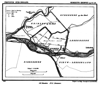
Krimpen aan de Lek is a town on the Lek River in the municipality of Krimpenerwaard, province of South Holland, the Netherlands. It had 6,607 inhabitants in 2008.

Gouderak is a village in the Dutch province of South Holland. It is located 4 km southwest of Gouda on the river Hollandsche IJssel, in the municipality of Krimpenerwaard.

Hogeveen is a hamlet in the Dutch province of South Holland. It is located in the municipality of Alphen aan den Rijn, about 2 km south of Hazerswoude-Dorp.

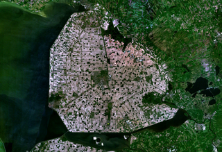
Krimpenerwaard is a municipality of the Netherlands. It is a rural area located in the east of the province of South Holland, just south of Gouda and east of the Rotterdam conurbation. It is bordered on the north by the river Hollandse IJssel, on the south by the river Lek and on the east by the stream Vlist.
Zuid-Holland Oost is an official region of the province of South Holland in the Netherlands.

Hendrik Johannes "Rik" Grashoff is a Dutch engineer and politician. He is a member of the political party GreenLeft. From 23 November 2010 to 19 September 2012 he was a member of the House of Representatives. He focused on matters of agriculture, defense and public administration. On 20 May 2015 he returned to the House and took up the seat of Bram van Ojik.
De Lek was a heerlijkheid (manor) and municipality in the Netherlands, located in the province South-Holland. It is named after the Lek River.

Zuidplas is a municipality in the Netherlands located in the province of South Holland. It was established on 1 January 2010 by the joining of Moordrecht, Nieuwerkerk aan den IJssel and Zevenhuizen-Moerkapelle. It had a population of 41,753 in August 2017.
Runa was a 1,942 GRT cargo ship that was built in 1944 as Eichberg by Van der Giessen, Krimpen aan den IJssel, Netherlands for German owners. She was seized by the Allies in April 1945, passed to the Ministry of War Transport (MoWT) and renamed Empire Consent. In 1949, Empire Consent was sold into merchant service and renamed Runa. In 1964, she was sold to Greek owners and renamed Karyatis, serving until 1968 when she was scrapped.
Johanna van Polanen was a Dutch noblewoman. She was the daughter of John III of Polanen, Lord of Breda, and his wife, Odilia of Salm. The House of Polanen was a side branch of the still existing House of Wassenaer.
Pieter Jan "Piet Jan" van der Giessen was a sailor from the Netherlands, who represented his native country as at the 1952 Summer Olympics in Helsinki. Piet Jan, as crew member on the Dutch 5.5 Metre De Ruyter, took the 13th place with helmsman Wim de Vries Lentsch and fellow crew member Flip Keegstra.

Piet Arie de Ruiter was a Dutch politician. He served as a member of the House of Representatives of the Netherlands between 1971 and 1976 for the Labour Party. He also served on the Public Body Rijnmond.