The honeyeaters are a large and diverse family, Meliphagidae, of small to medium-sized birds. The family includes the Australian chats, myzomelas, friarbirds, wattlebirds, miners and melidectes. They are most common in Australia and New Guinea, and found also in New Zealand, the Pacific islands as far east as Samoa and Tonga, and the islands to the north and west of New Guinea known as Wallacea. Bali, on the other side of the Wallace Line, has a single species.

The blue-faced honeyeater, also colloquially known as the bananabird, is a passerine bird of the honeyeater family, Meliphagidae. It is the only member of its genus, and it is most closely related to honeyeaters of the genus Melithreptus. Three subspecies are recognised. At around 29.5 cm (11.6 in) in length, the blue-faced species is large for a honeyeater. Its plumage is distinctive, with olive upperparts, white underparts, and a black head and throat with white nape and cheeks. Males and females are similar in external appearance. Adults have a blue area of bare skin on each side of the face readily distinguishing them from juveniles, which have yellow or green patches of bare skin.

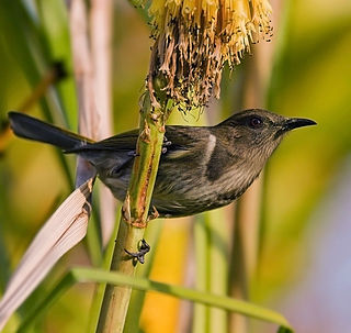
The black-chinned honeyeater is a species of passerine bird in the family Meliphagidae. It is endemic to Australia. Two subspecies are recognised. Its natural habitats are temperate forests and subtropical or tropical dry forests.
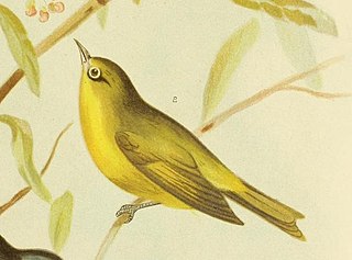
The canary white-eye or yellow white-eye is a species of white-eye endemic to northern Australia in subtropical or tropical mangrove forests. Its common name reflects the circle of white feathers around its eye.

Bigge Island is an island off the coast of the Kimberley region in Western Australia, within the Shire of Wyndham-East Kimberley.

The Birds of Western Australia is a book first published in 1948 by Patersons Press Ltd in Perth, Western Australia. Its full title was originally A Handbook of the Birds of Western Australia , though with the publication of the 5th edition only the shorter form was used. It was authored by Dominic Serventy and Hubert Whittell. It was issued in octavo format and contains 372 pages bound in blue buckram with a dustjacket illustrated with a painting of Australian pelicans by Harley Webster. It contains a coloured frontispiece of paintings of the heads of Meliphaga honeyeaters, with numerous black-and-white drawings and maps scattered through the text. The second edition (1951) contained colour plates by Olive Seymour.
The Prince Regent and Mitchell River Important Bird Area is a 7333 km2 tract of land comprising several contiguous protected areas in the north-west Kimberley region of northern Western Australia. It includes the Mitchell Plateau.
There are over 2,500 islands lying off the coast of the Kimberley region of Western Australia.
Charnley River–Artesian Range Wildlife Sanctuary is a protected area covering about 3,000 square kilometres (1,200 sq mi) in the Kimberley region of Western Australia. It is situated about 205 kilometres (127 mi) east of Derby and 287 kilometres (178 mi) north west of Halls Creek, and is accessed via the Gibb River Road. It is named after the Charnley River that flows through the property.
Boongaree Island is located off the Kimberley coast of Western Australia.
Coronation Island, also known as Garlinju, is located off the Kimberley coast of Western Australia. It encompasses an area of 3,817 hectares. It is located off Port Nelson in the Bonaparte Archipelago, as a part of the group of islands known as the Coronation Islands, which were named by Philip Parker King, the first European to visit the islands in 1820, after the anniversary of the coronation of George III, who had died in January of that year.
Sir Graham Moore Island, also known as Niiwalarra, is located off the Kimberley coast of Western Australia.
Middle Osborn Island is an island off the coast of the Kimberley region in Western Australia.
Hidden Island, known to the traditional owners as Banggoon, is an uninhabited island located in the Kimberley region of Western Australia.
Katers Island is an uninhabited island located in the Kimberley region of Western Australia.

St Andrew Island is an uninhabited island located in the Kimberley region of Western Australia.
South West Osborn Island is an island off the coast of the Kimberley region in Western Australia.
Champagny Island, known to the Traditional Owners as Nimenba, is an island off the coast of the Kimberley region in Western Australia.
Eucalyptus kenneallyi, commonly known as Kenneally's white gum, is a species of tree that is endemic to two small islands off the Kimberley coast of Western Australia. It has smooth bark, lance-shaped adult leaves, flower buds in groups of seven, white flowers and cylindrical fruit.