The Wisconsin Glacial Episode, also called the Wisconsinan glaciation, was the most recent glacial period of the North American ice sheet complex. This advance included the Cordilleran Ice Sheet, which nucleated in the northern North American Cordillera; the Innuitian ice sheet, which extended across the Canadian Arctic Archipelago; the Greenland ice sheet; and the massive Laurentide ice sheet, which covered the high latitudes of central and eastern North America. This advance was synchronous with global glaciation during the last glacial period, including the North American alpine glacier advance, known as the Pinedale glaciation. The Wisconsin glaciation extended from approximately 75,000 to 11,000 years ago, between the Sangamon interglacial and the current interglacial, the Holocene. The maximum ice extent occurred approximately 25,000–21,000 years ago during the last glacial maximum, also known as the Late Wisconsin in North America.

Mount Jefferson is a stratovolcano in the Cascade Volcanic Arc, part of the Cascade Range in the U.S. state of Oregon. The second highest mountain in Oregon, it is situated within Linn County, Jefferson County, and Marion County and forms part of the Mount Jefferson Wilderness. Due to the ruggedness of its surroundings, the mountain is one of the hardest volcanoes to reach in the Cascades. It is also a popular tourist destination despite its remoteness, with recreational activities including hiking, backpacking, mountaineering, and photography. Vegetation at Mount Jefferson is dominated by Douglas-fir, silver fir, mountain hemlock, ponderosa pine, lodgepole pine, and several cedar species. Carnivores, insectivores, bats, rodents, deer, birds, and various other species inhabit the area.
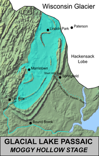
Lake Passaic was a prehistoric proglacial lake that existed in northern New Jersey in the United States at the end of the last ice age approximately 19,000-14,000 years ago. The lake was formed of waters released by the retreating Wisconsin Glacier, which had pushed large quantities of earth and rock ahead of its advance, blocking the previous natural drainage of the ancestral Passaic River through a gap in the central Watchung Mountains. The lake persisted for several thousand years as melting ice and eroding moraine dams slowly drained the former lake basin. The effect of the lake’s creation permanently altered the course of the Passaic River, forcing it to take a circuitous route through the northern Watchung Mountains before spilling out into the lower piedmont.
In geology, a proglacial lake is a lake formed either by the damming action of a moraine during the retreat of a melting glacier, a glacial ice dam, or by meltwater trapped against an ice sheet due to isostatic depression of the crust around the ice. At the end of the last ice age approximately 10,000 years ago, large proglacial lakes were a widespread feature in the northern hemisphere.

A jökulhlaup is a type of glacial outburst flood. It is an Icelandic term that has been adopted in glaciological terminology in many languages. It originally referred to the well-known subglacial outburst floods from Vatnajökull, Iceland, which are triggered by geothermal heating and occasionally by a volcanic subglacial eruption, but it is now used to describe any large and abrupt release of water from a subglacial or proglacial lake/reservoir.
The Tioughnioga River is a 34.2-mile-long (55.0 km) tributary of the Chenango River in central New York in the United States. It drains a dissected plateau area east of the Finger Lakes at the northernmost edge of the watershed of the Susquehanna River.
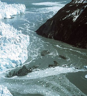
A glacial lake outburst flood (GLOF) is a type of outburst flood that occurs when the dam containing a glacial lake fails. An event similar to a GLOF, where a body of water contained by a glacier melts or overflows the glacier, is called a Jökulhlaup. The dam can consist of glacier ice or a terminal moraine. Failure can happen due to erosion, a buildup of water pressure, an avalanche of rock or heavy snow, an earthquake or cryoseism, volcanic eruptions under the ice, or if a large enough portion of a glacier breaks off and massively displaces the waters in a glacial lake at its base.

Moses Coulee is a canyon in the Waterville plateau region of Douglas County, Washington. Moses Coulee is the second-largest and westernmost canyon of the Channeled Scablands, located about 30 kilometres (19 mi) to the west of the larger Grand Coulee. This water channel is now dry, but during glacial periods, large outburst floods with discharges greater than 600,000 m3/s (21,000,000 cu ft/s) carved the channel. While it's clear that megafloods from Glacial Lake Missoula passed through and contributed to the erosion of Moses Coulee, the origins of the coulee are less clear. Some researchers propose that floods from glacial Lake Missoula formed Moses Coulee, while others suggest that subglacial floods from the Okanogan Lobe incised the canyon. The mouth of Moses Coulee discharges into the Columbia River.

The Traverse Gap is an ancient river channel occupied by Lake Traverse, Big Stone Lake and the valley connecting them at Browns Valley, Minnesota. It is located on the border of the U.S. states of Minnesota and South Dakota. Traverse Gap has an unusual distinction for a valley: it is crossed by a continental divide, and in some floods water has flowed across that divide from one drainage basin to the other. Before the Anglo-American Convention of 1818 it marked the border between British territory in the north and U.S. – or earlier, French – territory in the south.
Glacial River Warren or River Warren was a prehistoric river that drained Lake Agassiz in central North America between 11,700 and 9,400 years ago. The enormous outflow from this lake carved a large valley now occupied by the much smaller Minnesota River and the Upper Mississippi River. A part of the uppermost portion of the river channel was designated a National Natural Landmark in 1966.

The Foothills Erratics Train is a 580 miles (930 km) long, narrow, linear scatter of thousands of typically angular boulders of distinctive quartzite and pebbly quartzite that lie on the surface of a generally north-south strip of the Canadian Prairies. These boulders, which are between 1 foot (0.30 m) and 135 feet (41 m) in length, are glacial erratics that lie upon a surficial blanket of Late Wisconsin glacial till. The largest glacial erratic within the Foothills Erratics Train is Big Rock.

Grasshopper Glacier is located in Shoshone National Forest, in the US state of Wyoming on the east of the Continental Divide in the Wind River Range. Grasshopper Glacier is in the Fitzpatrick Wilderness, and is part of the largest grouping of glaciers in the American Rocky Mountains. The glacier flows north, and glacial runoff supplies water to Grasshopper Creek, flowing eventually into the Wind River. The glacier shares a glacial margin with Klondike Glacier, located to the south. The glacier is named for grasshoppers that have been found entombed in the ice.

The Valparaiso Moraine is a terminal moraine that forms an immense U around the Lake Michigan basin in North America. It is a band of high, hilly terrain made up of glacial till and sand. It begins near the border of Wisconsin and Illinois and extends south through Lake, McHenry, Cook, DuPage and Will counties in Illinois, and then turns southeast, entering Indiana. From this point, the moraine curves northeast through Lake, Porter, and LaPorte counties of Indiana into Michigan. It continues into Michigan as far as Montcalm County.

The Kankakee Outwash Plain is a flat plain interspersed with sand dunes in the Kankakee River valley in northwestern Indiana and northeastern Illinois of the United States. It is just south of the Valparaiso Moraine and was formed during the Wisconsin Glaciation. As the glacier, stopped at the Valparaiso Moraine, melted, the meltwater was carried away to the outwash plain. On the south side of the moraine, where the elevation drops, the meltwaters eroded away valleys, carrying sand and mud with them. As the muddy meltwater reached the valley where the slope lessened, the water slowed down, depositing the sand on the outwash plain. This created a smooth, flat, and sandy plain. Before its draining, the Kankakee Marsh, located on the outwash plain, was one of the largest freshwater marshes in the United States.

Overdeepening is a characteristic of basins and valleys eroded by glaciers. An overdeepened valley profile is often eroded to depths which are hundreds of metres below the deepest continuous line along a valley or watercourse. This phenomenon is observed under modern day glaciers, in salt-water fjords and fresh-water lakes remaining after glaciers melt, as well as in tunnel valleys which are partially or totally filled with sediment. When the channel produced by a glacier is filled with debris, the subsurface geomorphic structure is found to be erosionally cut into bedrock and subsequently filled by sediments. These overdeepened cuts into bedrock structures can reach a depth of several hundred metres below the valley floor.
The Trade River is a 50.8-mile-long (81.8 km) tributary of the St. Croix River in northwestern Wisconsin in the United States. In its history, it has been known by the names "Atanwa" or "Ottoway" River, both of which are Anglicized versions of an Ojibwe language word meaning "trade". Beneath the mouth of the Trade River, the St. Croix River was once known as the Grave-marker River.

Lake Kankakee formed 14,000 years before present (YBP) in the valley of the Kankakee River. It developed from the outwash of the Michigan Lobe, Saginaw Lobe, and the Huron-Erie Lobe of the Wisconsin glaciation. These three ice sheets formed a basin across Northwestern Indiana. It was a time when the glaciers were receding, but had stopped for a thousand years in these locations. The lake drained about 13,000 YBP, until reaching the level of the Momence Ledge. The outcropping of limestone created an artificial base level, holding water throughout the upper basin, creating the Grand Kankakee Marsh.
Lake Puyallup developed along the south edge of the Puget Sound Glacier. The glacier was in retreat northward after having reached its most southerly point. Drainage off the north face of Mount Rainier and the melting ice of the glacier was trapped in the valley of the Puyallup River. As the glacier moved north, the lake grew until it reached its largest capacity with the glacier at the glacial front across the Puyallup valley just south of Commencement Bay at Tacoma and northern bend of the White River at Auburn. When the ice retreated further north, it was reduced in depth and volume and takes on the name of Lake Tacoma.