Constanța, historically known as Tomis or Tomi, is a port city in the Dobruja historical region of Romania. As the country's fourth largest city and principal port on the Black Sea coast, Constanța is the capital of Constanța County. It is also the oldest continuously inhabited city in the region, founded around 600 BC, and among the oldest in Europe.

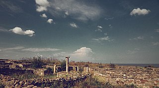
Mangalia, ancient Callatis, is a city and a port on the coast of the Black Sea in the south-east of Constanța County, Northern Dobruja, Romania.

In the Roman Republic and the Roman Empire, the Latin word castrum was a military-related term.
Histria or Istros, was a Greek colony or polis near the mouths of the Danube, on the western coast of the Black Sea. It was the first urban settlement on today's Romanian territory when founded by Milesian settlers in the 7th century BC. It was under Roman rule from the 1st to 3rd centuries AD. Invasions during the 7th century AD rendered it indefensible, and the city was abandoned. In antiquity, it also bore the names Istropolis, Istriopolis, and Histriopolis or simply Istros/Histros (Ἴστρος).
Located on Roman province of Dacia, present-day Romania, the Limes Porolissensis was a defensive line organized on 2nd century AD after the Conquest of Dacia, having observations towers, short cut-off walls fortifications, integrating the following castra:

The Limes Alutanus was a fortified line consisting of a vallum, built in the North-South direction, on the eastern side of the Olt river and seven Roman castra, as is remembered by Tabula Peutingeriana. Limes Alutanus was the eastern border of the Roman province of Dacia Superior.
Romanian archaeology begins in the 19th century.

Castra Buridava was a fort in the Roman province of Dacia.
The Castra of Albota was a castrum in the province of Dacia.
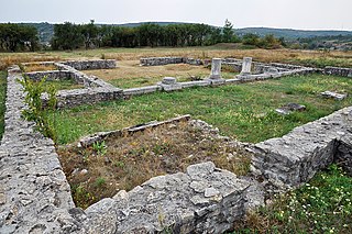
The castra of Buciumi was a fort in the Roman province of Dacia in the 2nd and 3rd centuries AD. Remains of the surrounding vicus were also unearthed. The castra's ruins are located in Buciumi, Romania.
The castra of Crâmpoia was a fort in the Roman province of Dacia. It was made of earth in the 2nd century AD. The Romans abandoned the fort in the 3rd century. Its ruins are located in Crâmpoia, Romania.
The castra of Fâlfani was a fort built in the 2nd century AD in the Roman province of Dacia. It was abandoned in the 3rd century. Its ruins are located on a hill in Fâlfani.

It was a fort in the Roman province of Dacia.
This section of the timeline of Romanian history concerns events from Late Neolithic until Late Antiquity, which took place in or are directly related with the territory of modern Romania.

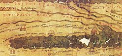
Ad Stoma was a fort in the Roman province of Moesia. As Tabula Peutingeriana shows it is situated between Histriopolis and Salsovia; 60 miles from Histriopolis and 24 miles from Salsovia.
Tomis was a fort in the Roman province of Moesia. According to Tabula Peutingeriana it is situated between Stratonis and Histriopolis.
The Antiquity in Romania spans the period between the foundation of Greek colonies in present-day Dobruja and the withdrawal of the Romans from "Dacia Trajana" province. The earliest records of the history of the regions which now form Romania were made after the establishment of three Greek towns—Histria, Tomis, and Callatis—on the Black Sea coast in the 7th and 6th centuries BC. They developed into important centers of commerce and had a close relationship with the natives. The latter were first described by Herodotus, who made mention of the Getae of the Lower Danube region, the Agathyrsi of Transylvania and the Sygannae of Crişana.
This page is based on this
Wikipedia article Text is available under the
CC BY-SA 4.0 license; additional terms may apply.
Images, videos and audio are available under their respective licenses.