

The Strawberry River is an 18-mile (29 km) river located in eastern Utah, United States. [1] [2]
The Strawberry River is an 18-mile (29 km) river located in eastern Utah, United States. [1] [2]
Strawberry River's headwaters is located in the Wasatch Mountains of the western Uintah Basin. The river flows south into Strawberry Reservoir, then through Soldier Creek Dam.
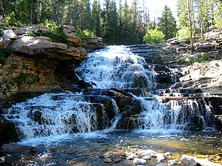
The first 8 miles (13 km) below Soldier Creek Dam is owned by the U.S. Bureau of Reclamation, and is one of Utah's most productive brown and cutthroat trout fisheries, and was one of the first waters in Utah to be designated a Quality Fishing Stream. [3] This part of the river can only be accessed by a trail that runs along the north bank. No motorized vehicles are allowed. [4] 12 miles (19 km) below Soldier Creek Dam, the river runs by the Strawberry Pinnacles (sedimentary formations), where it is joined by the tributaries Avintaquin Creek and Red Creek. The narrow canyon the river runs through is characterized by high cliffs and dense foliage.
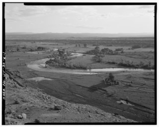
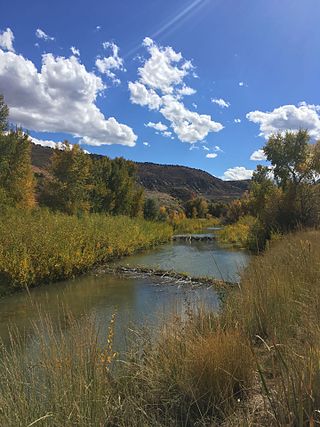
The river is impounded in the Starvation Reservoir within the Fred Hayes State Park at Starvation. After exiting the reservoir the stream joins the Duchesne River east of the town of Duchesne. [5]
During extremely cold winters, areas of the river have frozen solid, causing the river to overflow its banks and flood the canyon floor. This happened in 1983 and 2000.


The South Platte River is one of the two principal tributaries of the Platte River. Flowing through the U.S. states of Colorado and Nebraska, it is itself a major river of the American Midwest and the American Southwest/Mountain West. Its drainage basin includes much of the eastern flank of the Rocky Mountains in Colorado, much of the populated region known as the Colorado Front Range and Eastern Plains, and a portion of southeastern Wyoming in the vicinity of the city of Cheyenne. It joins the North Platte River in western Nebraska to form the Platte, which then flows across Nebraska to the Missouri. The river serves as the principal source of water for eastern Colorado. In its valley along the foothills in Colorado, it has permitted agriculture in an area of the Colorado Piedmont and Great Plains that is otherwise arid.

Duchesne County is a county in the northeast part of the U.S. state of Utah. As of the 2020 United States Census, the population was 19,596. Its county seat is Duchesne, and the largest city is Roosevelt.

Uintah County is a county in the U.S. state of Utah. As of the 2020 United States Census the population was 35,620. Its county seat and largest city is Vernal. The county was named for the portion of the Ute Indian tribe that lived in the basin.

Duchesne is a city in and the county seat of Duchesne County, Utah, United States. The population was 1,588 at the 2020 census.

The Salt River is a river in Gila and Maricopa counties in Arizona, United States, that is the largest tributary of the Gila River. The river is about 200 miles (320 km) long. Its drainage basin is about 13,700 square miles (35,000 km2) large. The longest of the Salt River's many tributaries is the 195-mile (314 km) Verde River. The Salt's headwaters tributaries, the Black River and East Fork, increase the river's total length to about 300 miles (480 km). The name Salt River comes from the fact that the river flows over large salt deposits shortly after the merging of the White and Black Rivers.

The Feather River is the principal tributary of the Sacramento River, in the Sacramento Valley of Northern California. The river's main stem is about 73 miles (117 km) long. Its length to its most distant headwater tributary is just over 210 miles (340 km). The main stem Feather River begins in Lake Oroville, where its four long tributary forks join—the South Fork, Middle Fork, North Fork, and West Branch Feather Rivers. These and other tributaries drain part of the northern Sierra Nevada, and the extreme southern Cascades, as well as a small portion of the Sacramento Valley. The total drainage basin is about 6,200 square miles (16,000 km2), with approximately 3,604 square miles (9,330 km2) above Lake Oroville.

The Price River is a 137-mile-long (220 km) southeastward flowing river in Carbon, Utah and Emery counties in eastern Utah. It is a tributary to the Green River, itself a tributary to the Colorado River.
Strawberry Reservoir is a large reservoir in the U.S. state of Utah. It is Utah's most popular fishery, receiving over 1.5 million angling hours annually and is part of the Blue Ribbon Fisheries program. Game fish in the reservoir include sterilized rainbow trout, bear lake cutthroat trout, kokanee salmon and crayfish. It is located 23 miles (37 km) southeast of Heber, Utah on U.S. Route 40. The reservoir is situated in Strawberry Valley. This valley is normally part of the Colorado River drainage. The dam was constructed to divert water into Utah Valley.

The Rio Chama, a major tributary river of the Rio Grande, is located in the U.S. states of Colorado and New Mexico. The river is about 130 miles (210 km) long altogether. From its source to El Vado Dam its length is about 50 miles (80 km), from El Vado Dam to Abiquiu Dam is about 51 miles (82 km), and from Abiquiu Dam to its confluence with the Rio Grande is about 34 miles (55 km).
The Provo River is located in Utah County and Wasatch County, Utah, in the United States. It rises in the Uinta Mountains at Wall Lake and flows about 71 miles (114 km) southwest to Utah Lake at the city of Provo, Utah.

The west end of U.S. Route 40 (US-40) is in the U.S. state of Utah at Silver Creek Junction in Silver Summit with Interstate 80. From there it heads southeast through Heber City and east into Colorado on its way to the Mid-Atlantic.
The Central Utah Project is a US federal water project that was authorized for construction under the Colorado River Storage Project Act of April 11, 1956, as a participating project. In general, the Central Utah Project develops a portion of Utah's share of the yield of the Colorado River, as set out in the Colorado River Compact of 1922.

Fred Hayes State Park at Starvation is a state park in Duchesne County, Utah, United States, featuring the 3,495-acre (1,414 ha) Starvation Reservoir. The park is 4 miles (6.4 km) northwest of the city of Duchesme.
Strawberry is an unincorporated community in western Duchesne County, Utah, United States. Most of the inhabitants live along the Strawberry River between the Strawberry River pinnacles and Starvation Reservoir west of the city of Duchesne, the county seat of Duchesne County.

The Clearwater River is in the northwestern United States, in north central Idaho. Its length is 74.8 miles (120.4 km), it flows westward from the Bitterroot Mountains along the Idaho-Montana border, and joins the Snake River at Lewiston. In October 1805, the Lewis and Clark Expedition descended the Clearwater River in dugout canoes, putting in at "Canoe Camp," five miles (8 km) downstream from Orofino; they reached the Columbia Bar and the Pacific Ocean about six weeks later.
The Duchesne River, located in the Uintah Basin region of Utah in the western United States, is a tributary of the Green River. The watershed of the river covers the Northeastern corner of Utah. The Duchesne River is 115 miles (185 km) long, and drains a total land area of 3,790 square miles (9,800 km2).
The Spanish Fork is a river in southeastern Utah County, Utah, United States.

The Colorado River is a major river of the western United States and northwest Mexico in North America. Its headwaters are in the Rocky Mountains where La Poudre Pass Lake is its source. Located in north central Colorado it flows southwest through the Colorado Plateau country of western Colorado, southeastern Utah and northwestern Arizona where it flows through the Grand Canyon. It turns south near Las Vegas, Nevada, forming the Arizona–Nevada border in Lake Mead and the Arizona–California border a few miles below Davis Dam between Laughlin, Nevada and Needles, California before entering Mexico in the Colorado Desert. Most of its waters are diverted into the Imperial Valley of Southern California. In Mexico its course forms the boundary between Sonora and Baja California before entering the Gulf of California. This article describes most of the major features along the river.
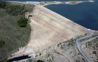
Soldier Creek Dam is an earthen dam on the Strawberry River, located within the Uinta National Forest in southern Wasatch County, Utah, United States.
![]() Media related to Strawberry River (Utah) at Wikimedia Commons
Media related to Strawberry River (Utah) at Wikimedia Commons
40°09′42″N110°23′19″W / 40.16167°N 110.38861°W
| | This article related to a river in Utah is a stub. You can help Wikipedia by expanding it. |