Vestre Moland is a former municipality in Aust-Agder county, Norway. The administrative centre of the municipality was the village of Møglestu where the Vestre Moland Church is located. The 103-square-kilometre (40 sq mi) municipality existed from 1838 until 1962 when it was merged into the municipality of Lillesand. Today, the area of Vestre Moland covers the northern part of the present-day municipality of Lillesand.

Rykene or Rygene is a village located along the river Nidelva in Aust-Agder county, Norway. The village is primarily located in Arendal municipality, but a small portion of the village lies across the river in the neighboring municipality of Grimstad. Rykene is located about 10 kilometres (6.2 mi) north of the town of Grimstad and about the same distance south of the city of Arendal. Historically, the village grew up due to its close proximity to forests as the timber was floated down river to the sawmills in Rykene. The village of Lindtveit lies about 2 kilometres (1.2 mi) to the northwest, the village of Løddesøl lies about 4 kilometres (2.5 mi) to the north, the village of Gjennestad lies about 3 kilometres (1.9 mi) to the northeast. The village sits at the junction of Norwegian County Road 407 and Norwegian County Road 408.

Blakstad or Blakstad-Osedalen is a village which is also the administrative centre of the municipality of Froland in Aust-Agder county, Norway. It is located along the river Nidelva, about 10 kilometres (6.2 mi) northwest of the town of Arendal. The small village of Froland lies about 3 kilometres (1.9 mi) to the north, on the west side of the river, and that is where Froland Church is located.
Barbu is part of the town of Arendal in Aust-Agder county, Norway. It is also a former municipality which existed from 1878 until 1902 when it was merged into Arendal. The 15.7-square-kilometre (6.1 sq mi) municipality was located just to the north of the 0.34-square-kilometre (84-acre) town of Arendal. The administrative centre of the small, urban municipality was called Barbu as well. Barbu Church was the church for the municipality. Today, the name Barbu refers to the village-like place located in head of the Galtesundet strait. Barbu is also a parish (sogn) in the Arendal prosti (deanery) within the Diocese of Agder og Telemark.

Moland is a former municipality in Aust-Agder county, Norway. The 127-square-kilometre (49 sq mi) municipality existed from 1962 until 1992 when it was merged into the present-day municipality of Arendal. The administrative centre of the municipality was the village of Eydehavn which had a population of 6,011 in 1967 and 8,148 in 1992. Other villages in the municipality included Kilsund, Narestø, Saltrød, Brekka, Strengereid, Vatnebu, and Sagene. The municipality consisted of the mainland area to the north and northeast of the town of Arendal plus the islands of Flostaøya and Tverrdalsøya.

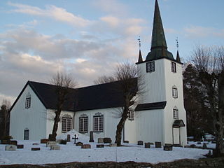
Tromøy is a former municipality in Aust-Agder county, Norway. The 30-square-kilometre (12 sq mi) municipality existed from 1878 until its dissolution in 1992. The municipal area is now part of the municipality of Arendal. The administrative centre was the village of Brekka where the historic Tromøy Church is located. The municipality encompassed all of the island of Tromøya as well as many smaller surrounding islands such as Merdø, Gjesøya, Skilsøy, and Tromlingene.

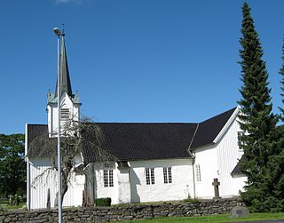
Austre Moland is a former municipality in Aust-Agder county, Norway. The municipality existed from 1838 until 1962 when it was merged into the neighboring municipality of Arendal. The administrative centre was at Brekka where the Austre Moland Church is located.

Eydehavn or Eydehamn is a village in the municipality of Arendal in Aust-Agder county, Norway. The village is located about 10 kilometres (6.2 mi) northeast of the centre of the town of Arendal, about 2 kilometres (1.2 mi) northeast of the village of Saltrød, about 2 kilometres (1.2 mi) south of the village of Strengereid, and just across the Tromøysundet strait from Kongshamn on the island of Tromøy. The village is named after Sam Eyde, the Norwegian engineer and industrialist. The local sports team is called IL Sørfjell. Eydehavn has about 1,100 residents as of 2015.
Brekka is a village in Arendal municipality in Aust-Agder county, Norway. The village is located along the European route E18 highway on the western shore of the lake Molandsvann. Brekka sits about 11 kilometres (6.8 mi) north of the town of Arendal and the village of Longum lies about 4.5 kilometres (2.8 mi) to the south. Historically, Brekka was the seat of the old municipality of Østre Moland. Austre Moland Church is located in this village.
Løddesøl is a village in Arendal municipality in Aust-Agder county, Norway. The village is located along the Norwegian County Road 408 on the eastern shore of the river Nidelva. The village lies about 2.5 kilometres (1.6 mi) south of the village of Rise, about 3 kilometres (1.9 mi) east of the village of Nævesdal, about 3 kilometres (1.9 mi) north of the village of Lindtveit, and about 7 kilometres (4.3 mi) west of the town of Arendal. The village has an elementary school and preschool as well as a sawmill and some small stores.
Sagene is a village in Arendal municipality in Aust-Agder county, Norway. The village is located about 2 kilometres (1.2 mi) northwest of the village of Strengereid in the Moland area of Arendal. The lake Langangsvannet lies just east of the village.

Østre Agder is a district or region in Aust-Agder county in southern Norway. The district covers the eastern, coastal areas of the county including the eight municipalities of Arendal, Tvedestrand, Risør, Grimstad, Gjerstad, Vegårshei, Åmli, and Froland. The city of Arendal is the largest city in the region. Other cities in the district include Tvedestrand, Grimstad, and Risør. This region is bounded by Telemark county to the north, by the Setesdal region to the northwest, and by the Kristiansand Region to the southwest.

Arendal is a city in Aust-Agder county, Norway. The city is the administrative centre of the municipality of Arendal and the seat of the County governor (Norway) of Aust-Agder. The city also includes some area in the neighboring municipality of Grimstad as well. In Norway, Arendal is considered a by which can be translated as either a "town" or "city" in English.
Flostaøya is an island in Arendal municipality in Aust-Agder county, Norway. The 7.9-square-kilometre (3.1 sq mi) island lies along the Skaggerak coast between the islands of Tromøy to the southwest and Tverrdalsøya to the northeast. The island lies about 11 kilometres (6.8 mi) northeast of the town of Arendal. Some of the larger villages on the island include Arnevik, Narestø, and Kalvøysund. The island has a bridge connection to the mainland at the southwest corner of the island and there is a bridge connection to Kilsund on the neighboring island of Tverrdalsøya at the north end.

Tverrdalsøya is an island in Arendal municipality in Aust-Agder county, Norway. The 3.4-square-kilometre (1.3 sq mi) island lies between the Oksefjorden, Eikelandsfjorden, and Kilsundet straits just off the mainland coast at the entrance to the Tvedestrandsfjorden which leads north to the town of Tvedestrand. The island of Flostaøya lies immediately to the south and the island of Borøy lies immediately to the east. The main population centre on the island is the village of Kilsund at the southern end of the island.


