
Dinas Emrys is a rocky and wooded hillock near Beddgelert in Gwynedd, north-west Wales. Rising some 76 m (250 ft) above the floor of the Glaslyn river valley, it overlooks the southern end of Llyn Dinas in Snowdonia.

A hillfort is a type of earthwork used as a fortified refuge or defended settlement, located to exploit a rise in elevation for defensive advantage. They are typically European and of the Bronze Age or Iron Age. Some were used in the post-Roman period. The fortification usually follows the contours of a hill and consists of one or more lines of earthworks, with stockades or defensive walls, and external ditches. Hillforts developed in the Late Bronze and Early Iron Age, roughly the start of the first millennium BC, and were used in many Celtic areas of central and western Europe until the Roman conquest.

Maiden Castle is an Iron Age hill fort 1.6 mi (2.6 km) south west of Dorchester, in the English county of Dorset. Hill forts were fortified hill-top settlements constructed across Britain during the Iron Age.

Carl Wark is a rocky promontory on Hathersage Moor in the Peak District National Park, just inside the boundary of Sheffield, England. The promontory is faced by vertical cliffs on all but one side, which is protected by a prehistoric embankment. The cliffs and embankment form an enclosure that has been interpreted as an Iron Age hill fort, though the date of construction and purpose of the fortifications remains unknown. The site is a scheduled monument.
Prideaux Castle is a multivallate Iron Age hillfort situated atop a 133 m (435 ft) high conical hill near the southern boundary of the parish of Luxulyan, Cornwall, England, United Kingdom. It is also sometimes referred to as Prideaux Warren, Prideaux War-Ring, or Prideaux Hillfort. The site is a scheduled monument and so protected from unauthorised works by the Ancient Monuments and Archaeological Areas Act 1979.

Yarnbury Castle is the site of a multiphase, multivallate Iron Age hillfort near the village of Steeple Langford, Wiltshire, England. The site covers an area of 28.5 acres (11.5 ha), and was extensively surveyed and investigated by the Royal Commission on the Historical Monuments of England in 1991, with finds of Iron Age and Romano-British pottery, Iron Age and Roman coins, and burials of human remains. There is much evidence of prolonged and extensive settlement of the site, including evidence of around 130 structures of various sizes, most probably representing a mix of round houses, pits, and other features.

Huntsham Castle, Devon, England is an Iron Age Hill fort enclosure near the village of Huntsham, it is located 260 m (850 ft) above sea level on the edge of the former Parish of Tiverton. The monument includes a slight univallate hillfort situated on a prominent hill overlooking the valleys of two separate tributaries to the River Lowman. The monument survives as a sub-circular enclosure, defining an area which slopes gently down to the south and measures approximately 150m in diameter. It is clearly demarcated on all sides by a rampart which varies in height from 1m up to 2.4m internally, being generally of greater height on the northern side of the enclosure. Externally this rampart is up to 2.9m high. Surrounding the rampart is an outer ditch which measures up to 5.4m wide and 0.4m deep and this is visible on all sides of the monument, although it is predominantly preserved as a buried feature. On the north eastern side, the outer edge of this ditch is defined by a field boundary bank and the infilled ditch has been used in the past as a track. There is an inturned entrance on the north eastern side which measures 7m wide, and the inturned banks are up to 2.2m wide and 0.4m high. The enclosure is crossed by a parish boundary bank which measures up to 2m wide and 1.5m high, and has been partially cut at the north eastern corner by a quarry, approximately 20m long, 15m wide and up to 2.8m deep, which lies to the north of the entrance. A further quarry lies to the south of the parish boundary bank, on the western side of the enclosure and measures 8.7 metres (29 ft) long, 5.3 metres (17 ft) wide and up to 1 metre (3.3 ft) deep. A third quarry lies to the north west and has partially cut into the ditch and rampart on this side; however much of this quarry lies just beyond the monument itself. A further entrance to the enclosure may lie on the western side, where the rampart is seen to kink slightly inwards. The stock proof fences around the rampart and ditch, the gates and gateposts which facilitate access, the Ordnance Survey triangulation point which is situated on the north eastern side of the enclosure just above the quarry, and the field boundary bank which defines the outer edge of the ditch in the north eastern corner are excluded from the scheduling, although the ground beneath all these features is included.
The Celtic hill fort of Otzenhausen is one of the biggest fortifications the Celts ever constructed. It was built by Gauls of the Treveri tribe, who lived in the region north of the fort. The fort is located on top of the Dollberg, a hill near Otzenhausen in Germany, about 695 m above sea level. The only visible remains are two circular earth ramparts, covered with stones.

Maiden Castle is an Iron Age hill fort, one of many fortified hill-top settlements constructed across Britain during the Iron Age, but one of only seven in the county of Cheshire in northern England. The hill fort was probably occupied from its construction in 600 BC until the Roman conquest of Britain in the 1st century AD. At this time the Cornovii tribe are recorded to have occupied parts of the surrounding area but, because they left no distinctive pottery or metalworking, their occupation has not been verified. Since then it has been quarried and used for military exercises. It is protected as a Scheduled Ancient Monument, and is owned by the National Trust. The hill fort is open to visitors, but unrestricted access to the site has resulted in it being classified as "at high risk" from erosion.

Burrough Hill is an Iron Age hillfort in Burrough on the Hill, 7 miles (11 km) south of Melton Mowbray in the English county of Leicestershire. Situated on a promontory about 210 metres (690 ft) above sea level, the site commands views over the surrounding countryside for miles around. There has been human activity in the area since at least the Mesolithic, and the hillfort was founded in the early Iron Age. In the medieval period, after the hillfort was abandoned, the hill was used as farmland. This ended in the 17th century when the parish the hill was in was enclosed. Traces of ridge and furrow show where the medieval fields were ploughed. Since the 1930s the site has been the subject of archaeological investigations and renewed excavations under the auspices of the University of Leicester began in 2010. Part of Burrough Hill Country Park and open to the public, the hillfort is protected as a Scheduled Ancient Monument.

Torsburgen, Tors borg or þors borg are the remains of an ancient hillfort in Kräklingbo on the Swedish island of Gotland in the Baltic Sea. The fort is approximately 1.2 km2 (0.46 sq mi), was constructed in the 1st-4th century and in use until the 12th century. Situated on a plateau hill it is protected by high cliffs and wall sections, almost 2 km (1.2 mi) long in total. The fort is featured in the Gutasaga. The plateau is also a nature reserve.

A circular rampart is an embankment built in the shape of a circle that was used as part of the defences for a military fortification, hill fort or refuge, or was built for religious purposes or as a place of gathering.
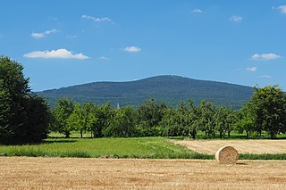
The Altkönig is the third highest mountain of the Taunus range in Hesse, Germany, reaching a height of 798.2 m above sea level (NHN).

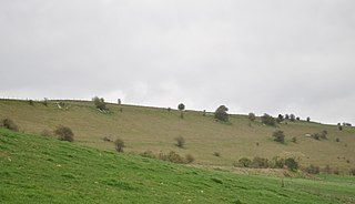
Scratchbury Camp is the site of an Iron Age univallate hillfort on Scratchbury Hill, overlooking the Wylye valley about 1 km northeast of the village of Norton Bavant in Wiltshire, England. The fort covers an area of 37 acres (15 ha) and occupies the summit of the hill on the edge of Salisbury Plain, with its four-sided shape largely following the natural contours of the hill.

Bratton Castle is a bivallate Iron Age built hill fort on Bratton Down, at the western edge of the Salisbury Plain escarpment. The hill fort comprises two circuits of ditch and bank which together enclose a pentagonal area of 9.3 hectares.
Grovely Castle is the site of an Iron Age univallate hill fort in the parish of Steeple Langford, in Wiltshire. The remaining ramparts stand approximately 3.2 m (10 ft) high, with 1.5 m (4.9 ft) deep ditches, although ploughing has damaged the earthworks in some parts of the site. Excavations have uncovered the remains of five human skeletons within the ramparts. Entrances are in the south-west and north-east corners of the hillfort. A circular enclosure of 35 to 40 m is evident in aerial photographs of the hillfort interior. There is also a later bank and ditch which runs through the hill-fort from south-west to north-east, and is probably part of an extensive surrounding Celtic field system.

Wildenburg Castle is a ruined castle near Kempfeld in the county of Birkenfeld in the German state of Rhineland-Palatinate.

The small ringwork of the Altes Schloss is all that remains of a, now levelled, early medieval fortification on one of the projecting hill spurs of the Mirsberg Heights on the Lange Meile in the valley of the Eggerbach. The spur is called the Schlossberg. The old castle site lies at a height of 493.4 m above sea level (NN) around 935 metres south-southeast of the Roman Catholic parish church of St. Margareta of Drügendorf in the Upper Franconian municipality of Eggolsheim in Bavaria, Germany. No historical or archaeological information about this hillfort exists, and there have been no finds that might be able to be used to date the site. Based on the design of the fortification it has been tentatively dated to the Carolingian-Ottonian period. All that has survived is a ringwork with an outer ditch in places. The fortification is protected today as heritage site number D-4-6132-0125: "Early Medieval Ringwork".

Lesingey Round is a ringfort, a smaller type of hillfort, about 1 mile (1.6 km) west of Penzance, in Cornwall, England. It is a scheduled monument.
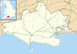
Banbury Hillfort, or Banbury Hill Camp, is an Iron Age hillfort, about 1.25 miles (2.0 km) south of Sturminster Newton and 1 mile (1.6 km) north-west of the village of Okeford Fitzpaine in Dorset, England.

