The Sacramento River is the principal river of Northern California in the United States, and is the largest river in California. Rising in the Klamath Mountains, the river flows south for 400 miles (640 km) before reaching the Sacramento–San Joaquin River Delta and San Francisco Bay. The river drains about 26,500 square miles (69,000 km2) in 19 California counties, mostly within the fertile agricultural region bounded by the Coast Ranges and Sierra Nevada known as the Sacramento Valley, but also extending as far as the volcanic plateaus of Northeastern California. Historically, its watershed has reached as far north as south-central Oregon where the now, primarily, endorheic (closed) Goose Lake rarely experiences southerly outflow into the Pit River, the most northerly tributary of the Sacramento.

Orting is a city in Pierce County, Washington, United States. The population as of the 2010 census is 6,746, according to the City of Orting.

Auburn is a city in King County, with a small portion in Pierce County, Washington, United States. The population was 70,180 at the 2010 United States Census. Auburn is a suburb in the Seattle metropolitan area, currently ranked the fifteenth largest city in the state of Washington.

Pacific is a city in King and Pierce counties in the State of Washington. Located primarily in King County, the population was 6,606 at the 2010 census. Like its northern neighbor Algona, Pacific is sometimes mistaken for a part of Auburn.

The Snoqualmie River is a 45-mile (72 km) long river in King County and Snohomish County in the U.S. state of Washington. The river's three main tributaries are the North, Middle, and South Forks, which drain the west side of the Cascade Mountains near the town of North Bend and join near the town of Snoqualmie just above the Snoqualmie Falls. After the falls the river flows north through rich farmland and the towns of Fall City, Carnation, and Duvall before meeting the Skykomish River to form the Snohomish River near Monroe. The Snohomish River empties into Puget Sound at Everett. Other tributaries of the Snoqualmie River include the Taylor River and the Pratt River, both of which enter the Middle Fork, the Tolt River, which joins at Carnation, and the Raging River at Fall City.

The Mohawk River is a 149-mile-long (240 km) river in the U.S. state of New York. It is the largest tributary of the Hudson River. The Mohawk flows into the Hudson in Cohoes, New York, a few miles north of the city of Albany. The river is named for the Mohawk Nation of the Iroquois Confederacy. It is a major waterway in north-central New York.

The Newaukum River is a tributary of the Chehalis River in the U.S. state of Washington. It has three main branches, the North Fork, South Fork, and Middle Fork Newaukum Rivers. The length of the three forks and the mainstem river is 56.7 miles (91.2 km).

The South Santiam River is a tributary of the Santiam River, about 69 miles (111 km) long, in western Oregon in the United States. It drains an area of the Cascade Range into the Willamette Valley east of Corvallis.

The Hoh River is a river in the U.S. state of Washington, located on the Olympic Peninsula. About 56 miles (90 km) long, the Hoh River originates at the Hoh Glacier on Mount Olympus and flows west through the Olympic Mountains of Olympic National Park and Olympic National Forest, then through the foothills in a broad valley, emptying into the Pacific Ocean at the Hoh Indian Reservation. The final portion of the Hoh River's course marks the boundary between the coastal segment of Olympic National Park and Olympic National Forest, the Hoh Indian Reservation.

The Skokomish River is a river in Mason County, Washington, United States. It is the largest river flowing into Hood Canal, a western arm of Puget Sound. From its source at the confluence of the North and South Forks the main stem Skokomish River is approximately 9 miles (14 km) long. The longer South Fork Skokomish River is 40 miles (64 km), making the length of the whole river via its longest tributary about 49 miles (79 km). The North Fork Skokomish River is approximately 34 miles (55 km) long. A significant part of the Skokomish River's watershed is within Olympic National Forest and Olympic National Park.
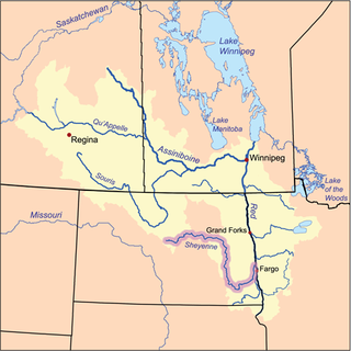
The Sheyenne River is one of the major tributaries of the Red River of the North, meandering 591 miles (951 km) across eastern North Dakota, United States.

The Big River is a tributary of the Meramec River in east-central Missouri. The river rises in western Iron County (37.6899°N 90.9656°W), near the summit of Johnson Mountain and the locale of Enough; it flows through Washington County, Saint Francois County, and Jefferson County. It forms part of the boundary between Jefferson County and Saint Francois County and also part of the boundary between Jefferson County and Washington County. It empties into the Meramec River opposite Eureka (38.4720°N 90.6188°W), where the Meramec forms the border between Jefferson County and Saint Louis County. The river flows through Washington State Park, St. Francois State Park, and the Lead Belt mining district. The elevation of the river at its source is approximately 1,300 feet (400 m) above sea level and at its mouth about 400 feet (120 m). The length of the river is approximately 145 miles (233 km), while the airline distance between source and mouth is about 56 miles (90 km). Its watershed area is 955 square miles (2,470 km2).
KRIZ is a radio station broadcasting a gospel format. Licensed to Renton, Washington, United States, it serves the Seattle area. The station is currently owned by the Kris Bennett Broadcasting Co., Inc.

The Napeequa River is a 19-mile (31 km) long river in the U.S. state of Washington on the east side of the Cascade Range. It rises in northwest Chelan County and flows southwest into the White River near Twin Lakes. The White River flows into Lake Wenatchee. The Napeequa River and its valley are notable for their beauty and isolation, as well as their interesting geological history. It flows through an isolated southeast-trending valley characterized by a broad meadows surrounded by rugged mountains. The Chiwawa Mountains, or Chiwawa Ridge mark the east side of the valley, separating the Napeequa and Chiwawa Rivers. To the west the White Mountains separate the Napeequa from the White River. Both are sub-ranges of the Cascade Range.

The Sol Duc River is a river in the U.S. state of Washington. About 78 miles (126 km) long, it flows west through the northwest part of the Olympic Peninsula, from the Olympic Mountains of Olympic National Park and Olympic National Forest, then through the broad Sol Duc Valley. Near the Pacific Ocean the Sol Duc River joins the Bogachiel River, forming the Quillayute River, which flows about 4 miles (6.4 km) to the Pacific Ocean at La Push. Although the Quillayute River is short, its large tributary rivers—the Sol Duc, Bogachiel, Calawah, and Dickey Rivers—drain the largest watershed of the northern Olympic Peninsula, 629 square miles (1,630 km2). The Sol Duc's watershed is the largest of the Quillayute's tributaries, at 219 square miles (570 km2).
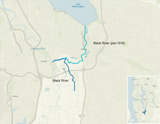
The Black River is a tributary of the Duwamish River in King County in the U.S. state of Washington. It drained Lake Washington until 1916, when the opening of the Lake Washington Ship Canal lowered the lake, causing part of the Black River to dry up. It still exists as a dammed stream about 2 miles (3.2 km) long.

The Pequonnock River is a 16.7-mile-long (26.9 km) waterway in eastern Fairfield County, Connecticut, flowing through the city of Bridgeport. The river has a penchant for flooding, particularly in spring since the removal of a retention dam in Trumbull in the 1950s. There seems to be a sharp difference of opinion among historians as to just what the Indian word Pequonnock signifies. Some insist it meant cleared field or open ground; others are sure it meant broken ground; while a third group is certain it meant place of slaughter or place of destruction.

The Willamette Valley is a 150-mile (240 km) long valley in the Pacific Northwest region of the United States. The Willamette River flows the entire length of the valley, and it is surrounded by mountains on three sides – the Cascade Range to the east, the Oregon Coast Range to the west, and the Calapooya Mountains to the south. It forms the cultural and political heart of Oregon, and is home to approximately 70 percent of its population including its six largest cities: Portland, Eugene, Salem, the state capital, and the cities of Gresham, Hillsboro and Beaverton in the Portland metropolitan area. Eight of Oregon's ten – and 16 of its 20 – largest cities are located in the Willamette Valley.

Mud Mountain Dam is a dam in King County, Washington, a few miles southeast of Enumclaw. The dam impounds the White River and is used for flood control.