
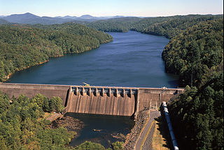
Douglas Dam is a hydroelectric dam on the French Broad River in Sevier County, Tennessee, in the southeastern United States. The dam is operated by the Tennessee Valley Authority (TVA), which built the dam in record time in the early 1940s to meet emergency energy demands at the height of World War II. Douglas Dam is a straight reinforced concrete gravity-type dam 1705 feet long and 202 feet high, impounding the 28,420-acre (11,500 ha) Douglas Lake. The dam was named for Douglas Bluff, a cliff overlooking the dam site prior to construction.

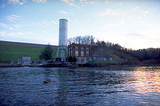
Croton Dam is an earth-filled embankment dam and powerplant complex on the Muskegon River in Croton Township, Newaygo County, Michigan. It was built in 1907 under the direction of William D. Fargo by the Grand Rapids - Muskegon Power Company, a predecessor of Consumers Energy. The 40-foot-high (12 m) dam impounds 7.2 billion U.S. gallons (6 billion imp. gal/27 billion L) of water in its 1,209-acre (489 ha) reservoir and is capable of producing 8,850 kilowatts at peak outflow. It was listed on the National Register of Historic Places in 1979.
Apalachia Dam is a hydroelectric dam on the Hiwassee River in Cherokee County, in the U.S. state of North Carolina. The dam is the lowermost of three dams on the river owned and operated by the Tennessee Valley Authority, which built the dam in the early 1940s to provide emergency power for aluminum production during World War II. While the dam is in North Carolina, an 8.3-mile (13.4 km) underground conduit carries water from the dam's reservoir to the powerhouse located 12 miles (19 km) downstream across the state line in Polk County, Tennessee. The dam and associated infrastructure were listed on the National Register of Historic Places in 2017.

Hardy Dam is an earth-filled embankment dam and powerplant complex on the Muskegon River in Big Prairie Township, Newaygo County, Michigan. At the time of its completion, it was the largest earthen dam in North America east of the Mississippi. Its impoundment forms a lake with over 50 miles of shoreline. The dam impounds a reservoir with a surface area of 4,000 acres and its power plant has an installed capacity of 31.5 MW.
Blue Ridge Dam is a hydroelectric dam on the Toccoa River in Fannin County, in the U.S. state of Georgia. It is the uppermost of four dams on the Toccoa/Ocoee River owned and operated by the Tennessee Valley Authority. The dam impounds the 3,300-acre (1,300 ha) Blue Ridge Lake on the southwestern fringe of the Blue Ridge Mountains.

Hiwassee Dam is a hydroelectric dam on the Hiwassee River in Cherokee County, in the U.S. state of North Carolina. It is one of three dams on the river owned and operated by the Tennessee Valley Authority, which built the dam in the late 1930s to bring flood control and electricity to the region. The dam impounds the Hiwassee Lake of 6,000 acres (2,400 ha), and its tailwaters are part of Apalachia Lake. At 307 feet (94 m), Hiwassee Dam is the third highest dam in the TVA system, behind only Fontana and Watauga. The dam and associated infrastructure was listed on the National Register of Historic Places in 2017.
Hydroelectric power in the United States is, as of 2019, the second-largest renewable source of energy in both generation and nominal capacity. In 2019, hydroelectric power produced 38% of the total renewable electricity, and 6.6% of the total U.S. electricity.

The Yeywa Hydropower Station, located on the Myitnge River, 52 kilometres (32 mi) southeast of Mandalay city, at Yeywa village in Kyaukse Township, Mandalay Region in central Myanmar, is the country's first roller-compacted concrete (RCC) dam, and the site of a 790-megawatt (1,060,000 hp) hydroelectric power plant, the largest in the country.

Hauser Dam is a hydroelectric straight gravity dam on the Missouri River about 14 miles (23 km) northeast of Helena, Montana, in the United States. The original dam, built between 1905 and 1907, failed in 1908 and caused severe flooding and damage downstream. A second dam was built on the site in 1908 and opened in 1911 and comprises the present structure. The current Hauser Dam is 700 feet (210 m) long and 80 feet (24 m) high. The reservoir formed by the dam, Hauser Lake is 25 miles (40 km) long, has a surface area of 3,800 acres (1,500 ha), and has a storage capacity of 98,000 acre-feet (121,000,000 m3) of water when full.

New Don Pedro Dam, often known simply as Don Pedro Dam, is an earthen embankment dam across the Tuolumne River, about 2 miles (3.2 km) northeast of La Grange, in Tuolumne County, California. The dam was completed in 1971, after four years of construction, to replace the 1924 concrete-arch Don Pedro Dam.

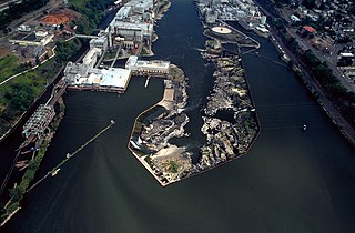
Pit-3 Dam is a hydroelectric dam on the Pit River in northern California in the United States. It forms Lake Britton, and is owned by the Pacific Gas and Electric Company (PG&E).

The Kishanganga Hydroelectric Project is a run-of-the-river hydroelectric scheme in Kashmir, India. Its dam diverts water from the Kishanganga River to a power plant in the Jhelum River basin. It is located near Dharmahama Village, 5 km (3 mi) north of Bandipore in Jammu and Kashmir and has an installed capacity of 330 MW.
Cooke Dam is a hydro-electric dam on the Au Sable River in Michigan. It was listed on the National Register of Historic Places in 1996 as the Cooke Hydroelectric Plant.
Moccasin Dam is a small dam on Moccasin Creek in Tuolumne County, California, in the town of Moccasin, west of Yosemite. It holds the Moccasin Reservoir. The dam, reservoir and associated hydroelectric power plant are part of the Hetch Hetchy Project, which provide water and power to the city of San Francisco. The dam is located near the junction of Highway 120 and Highway 49.

The French Landing Dam and Powerhouse is a hydroelectric gravity dam and powerhouse crossing the Huron River in Van Buren Charter Township in Wayne County in the state of Michigan. The dam and the powerhouse were completed in 1925 by the Detroit Edison Company on land previously purchased in 1910. The dam and powerhouse were designated as a Michigan State Historic Site on February 18, 1982.
Portland General Electric's (PGE) T. W. Sullivan Hydroelectric Plant is a hydroelectric dam on the Willamette Falls built between 1888 and 1895. It is the source of the nation's first long-distance power transmission. The plant first opened with Station A in 1889. In 1895 a second powerhouse was built on the same dam, Station B, and Station A was removed. Station B. In 1953 Station B was renamed after the engineer who designed it and nearby paper mills, Thomas Sullivan. By that year, the plant was generating between 11,000 and 17,500 kilowatts, which it still does today. PGE's Sullivan Plant at Willamette Falls is one of only a few dozen hydro-plants in the country officially designated as "Green." In the 1920s a portion of the paper mill was put on top of the dam, which is still operating.
The Argo Dam is a decommissioned hydroelectric barrage dam crossing the Huron River. It is located in the city of Ann Arbor in Washtenaw County in the U.S. state of Michigan. It was built by the Detroit Edison Company in 1920 for hydroelectricity before being decommissioned in 1959 and sold to the city of Ann Arbor in 1963. The surrounding area is used for recreational purposes, including Argo Nature Area and Bandemer Park.

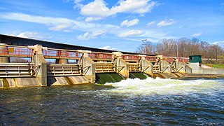
Mio Dam is a hydro-electric dam located on the Au Sable River in Michigan capable of generating 4.96 MW of electric power. It was the 4th of 6 dams built by Consumers Power between 1906 and 1924 along the Au Sable River and is the furthest upstream of the six. The dam was completed in 1916. The Mio Hydroelectric Plant consists of an embankment on each side connected by a spillway. Located North of the spillway is the powerhouse and outdoor substation. Public access to Mio Pond is provided via a boat ramp maintained by Consumers Energy, and portage facilities are also provided allowing canoes and kayaks access to bypass the dam. Portage the dam on the right using the cement stairs then carry down a gravel road with a canoe slide on the down river side of the dam. The Mio Dam powerhouse continues to operate with the same turbines and generators that were installed over a century ago.

Seattle Municipal Light and Power Plant, also known as Cedar Falls Historic District, is a public hydroelectric plant near North Bend, Washington operated by Seattle City Light. The plant was the first publicly-owned electrical generating plant for Seattle and one of the earliest in the country for a municipality of its size. It was listed on the National Register of Historic Places in 1997.

The Barton Dam is a hydroelectric barrage dam crossing the Huron River. It is located in the city of Ann Arbor in Washtenaw County in the U.S. state of Michigan. It began operating in 1912 and currently provides hydroelectricity to city of Ann Arbor, which owns and maintains the dam and power station.
