Stöcklewald

Last updated
Stöcklewald

Stocklewald nahe Stocklewaldturm.jpg

The Stöcklewald
Highest point
Elevation 1,068.2 m above  sea level (NHN) (3,505 ft)
Coordinates 48°05′30″N8°15′14″E / 48.09167°N 8.25389°E / 48.09167; 8.25389 Coordinates: 48°05′30″N8°15′14″E / 48.09167°N 8.25389°E / 48.09167; 8.25389
Geography
Parent range Black Forest

The Stöcklewald is a mountain, 1,068.2 m above  sea level (NHN) , [1] in the southern part of the Central Black Forest in Germany between the towns of Furtwangen and Triberg, each about 5 kilometres distant, in the county of Schwarzwald-Baar-Kreis. Towards the north, the Black Forest only exceeds this height again in the area of the Schliffkopf and the Hornisgrinde.

<i>Normalhöhennull</i> standard reference level, the equivalent of sea level, used in Germany to measure height

Normalhöhennull or NHN is a vertical datum used in Germany.

Central Black Forest

The Central Black Forest, also called the Middle Black Forest, is a natural or cultural division that generally refers to a region of deeply incised valleys from the Rench valley and southern foothills of the Kniebis in the north to the area of Freiburg im Breisgau and Donaueschingen in the south. Its highest area, which is southeast of the Elz valley, is also part of the High Black Forest.

Germany Federal parliamentary republic in central-western Europe

Germany, officially the Federal Republic of Germany, is a country in Central and Western Europe, lying between the Baltic and North Seas to the north, and the Alps to the south. It borders Denmark to the north, Poland and the Czech Republic to the east, Austria and Switzerland to the south, France to the southwest, and Luxembourg, Belgium and the Netherlands to the west.

Contents

Location

The European Watershed between the Rhine and the Danube runs over the mountain. On its northern slopes rises the Gutach, which flows from here in a northwesterly direction through the Schönwald Highlands and drops over its northeastern edge as the Triberg Waterfalls. To the southeast flow the tributary streams of the Breg.

Rhine river in Western Europe

The Rhine is a European river that begins in the Swiss canton of Graubünden in the southeastern Swiss Alps, forms part of the Swiss-Liechtenstein, Swiss-Austrian, Swiss-German and then the Franco-German border, then flows through the German Rhineland and the Netherlands and eventually empties into the North Sea.

Danube river in Central Europe

The Danube, known by various names in other languages, is Europe's second longest river, after the Volga. It is located in Central and Eastern Europe.

Gutach (Kinzig) river in Germany

Gutach is a river of Baden-Württemberg, Germany. It passes through Triberg im Schwarzwald and Gutach (Schwarzwaldbahn), and flows into the Kinzig near Hausach. The Triberg Waterfalls are formed by the Gutach.

The northern foot of its gently-sloping domed summit may be reached on local Landesstraßen and Kreisstraße n, both from the aforementioned towns as well as from Schönwald and Brigach. From there a road runs up to the summit, where there is a Gasthaus , a hiker's home belonging to the Black Forest Club and the Stöcklewald Tower.

<i>Landesstraße</i> type of "state roads" mainly in Austria and Germany

Landesstraßen are roads in Germany and Austria that are, as a rule, the responsibility of the respective German or Austrian federal state. The term may therefore be translated as "state road". They are roads that cross the boundary of a rural or urban district. A Landesstraße is thus less important than a Bundesstraße or federal road, but more significant than a Kreisstraße or district road. The classification of a road as a Landesstraße is a legal matter (Widmung). In the free states of Bavaria and Saxony – but not, however, in the Free State of Thuringia – Landesstraßen are known as Staatsstraßen.

Kreisstraße class of road in Germany

A Kreisstraße is a class of road in Germany. It carries traffic between the towns and villages within a Kreis or district or between two neighbouring districts. In importance, the Kreisstraße ranks below a Landesstraße, but above a Gemeindestraße or "local road". Kreisstraßen are usually the responsibility of the respective rural district (Landkreis) or urban district, with the exception of high streets through larger towns and villages. Kreisstraßen are usually dual-lane roads but, in a few cases, can be built as limited-access dual carriageways in densely populated areas.

Schönwald im Schwarzwald Place in Baden-Württemberg, Germany

Schönwald im Schwarzwald is a small village in the state of Baden-Württemberg in the Black Forest in southwest Germany, near the France–Germany border and Germany–Switzerland border.

The parish boundary between the village of Rohrbach (in the borough of Furtwangen) and the municipality of Schönwald runs over the summit. The parish of Nußbach in the borough of Triberg also owns part of the northern mountainside. The summit with its tower and the hiking home lie within the parish of Furtwangen-Rohrbach.

Stöcklewald Tower

The roughly 25-metre-high observation tower was erected in 1894 by the Triberg Branch of the Black Forest Club in the shape of a round tower in the borough of Furtwangen and was inaugurated in May 1895. It is a popular destination on the Middle Way managed by the Black Forest Club. From the observation platform there are views over the Central Black Forest to the Feldberg and also a panorama of the Swabian Jura as well as views of the Alps from the Zugspitze to Mont Blanc. The platform is reached via a staircase with 127 steps.

Observation tower structure used to view events from a long distance

An observation tower is a structure used to view events from a long distance and to create a full 360 degree range of vision to conduct the long distance observations. They are usually at least 20 metres (65.6 ft) tall and made from stone, iron, and wood. Many modern towers are also used as TV towers, restaurants, or churches. The towers first appeared in Germany at the end of the 18th century, and their numbers steadily increased, especially after the invention of the lift.

Feldberg (Black Forest) Mountain in the Black Forest, Baden-Württemberg, Germany

At 1,493 metres (4,898 ft) the Feldberg in the Black Forest is the highest mountain in Baden-Württemberg, and the highest in Germany outside of the Alps. The local municipality of Feldberg was named after the mountain.

Swabian Jura low mountain range in Germany

The Swabian Jura, sometimes also named Swabian Alps in English, is a mountain range in Baden-Württemberg, Germany, extending 220 km (140 mi) from southwest to northeast and 40 to 70 km in width. It is named after the region of Swabia.

The Stöcklewald Tower is also used as a communications relay station for police, THW, fire service, rescue services and amateur radio users. The tower also acts as a radio relay station for broadband and internet services to the surrounding parishes.

Amateur radio use of designated radio frequency spectra for purposes of non-commercial exchange of messages

Amateur radio, also known as ham radio, describes the use of radio frequency spectrum for purposes of non-commercial exchange of messages, wireless experimentation, self-training, private recreation, radiosport, contesting, and emergency communication. The term "amateur" is used to specify "a duly authorised person interested in radioelectric practice with a purely personal aim and without pecuniary interest;" and to differentiate it from commercial broadcasting, public safety, or professional two-way radio services.

Surrounding area

Around 800 metres northeast of the summit, near the road on the heights known as Hochgericht (1,020.6 m) are the Triberg Gallows. Another kilometre further northeast is a subpeak of the Stöcklewald, the Kesselberg (1,024.2 m) near an important crossroads. On the slopes of the mountain rises the Brigach stream and its most important tributary, the Kirnach. The Kesselberg Fault that runs through here is named after the mountain. This is a significant reason why the Stöcklewald peak is so clearly uplifted above the eastern slopes of the Black Forest, because it has retained a remnant in the fault zone of the bunter sandstone that originally lay on the basement.

Triberg Gallows

The Triberg Gallows is a double gallows on the heights known as Hochgericht on the K 5728 county road that runs from Schönwald to Villingen, and in the county of Schwarzwald-Baar-Kreis in the German state of Baden-Württemberg.

Brigach river in Germany

The Brigach is the shorter of two streams that jointly form the river Danube in Baden-Württemberg, Germany. The Brigach has its source at 925 m (3,035 ft) above sea level within St. Georgen in the Black Forest. The Brigach crosses the city Villingen-Schwenningen. 40.4 km (25.1 mi) from the source, the Brigach joins the Breg in Donaueschingen to form the Danube River.

In geology, a fault is a planar fracture or discontinuity in a volume of rock, across which there has been significant displacement as a result of rock-mass movement. Large faults within the Earth's crust result from the action of plate tectonic forces, with the largest forming the boundaries between the plates, such as subduction zones or transform faults. Energy release associated with rapid movement on active faults is the cause of most earthquakes.

Also in the surrounding area are sights such as St. Hubert's Chapel, a monument to popular religious devotion in an idyllic setting, the Triberg Waterfalls, one of the highest and best known waterfalls in Germany, and the source of the Brigach.

Related Research Articles

Black Forest mountain range in Baden-Württemberg, southwestern Germany

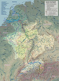
The Black Forest is a large forested mountain range in the state of Baden-Württemberg in southwest Germany. It is bounded by the Rhine valley to the west and south. Its highest peak is the Feldberg with an elevation of 1,493 metres (4,898 ft). The region is roughly oblong in shape with a length of 160 km (99 mi) and breadth of up to 50 km (31 mi).

Abnoba water deity

Abnoba is a name with theological and geographical meanings: It is the name of a Gaulish goddess who was worshiped in the Black Forest and surrounding areas. It is also the name of a mountain or mountain range.

Breg (river) river in Germany

The Breg is a river, 46 kilometres long, in Baden-Württemberg, Germany, and the primary headstream of the Danube.

Hornisgrinde mountain

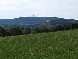
The Hornisgrinde, 1,164 m (3,820 ft), is the highest mountain in the Northern Black Forest of Germany. The Hornisgrinde lies in northern Ortenaukreis district.

The Baden Black Forest Railway is a twin-track, electrified railway line in Baden-Württemberg, Germany, running in a NW-SE direction to link Offenburg on the Rhine Valley Railway (Rheintalbahn) with Singen on the High Rhine Railway (Hochrheinbahn). Passing directly across the Black Forest, through spectacular scenery, the route is 150 km long, ascends 650 metres from lowest to highest elevation, and passes through 39 tunnels and over 2 viaducts. It is still the only true mountain railway in Germany to be built with two tracks, and is the most important railway line in the Black Forest. It was built between 1863 and 1873, utilizing plans drawn up by Robert Gerwig.

Graham Mountain (New York) Highest privately owned summit in New Yorks Catskill Mountains

Graham Mountain is the seventh highest of the Catskill High Peaks and the highest privately owned mountain in the range. It is located in the town of Hardenburgh, New York, United States.

Baar (region) plateau in southwestern Germany

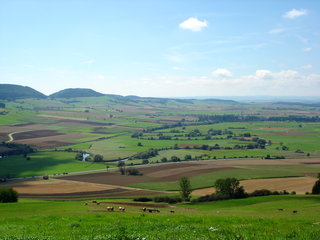
The Baar is a plateau that lies 600 to 900 metres above sea level in southwest Germany. It is bordered by the southeastern edge of the Black Forest to the west, the southwestern part of the Swabian Alb known as the Heuberg to the east, and the Randen mountain to the south.

Badener Höhe mountain

The Badener Höhe is a mountain in the Northern Black Forest in the German state of Baden-Württemberg. It lies within the borough of Baden-Baden and municipality of Forbach. With a height of 1,002.5 m above sea level (NHN), it is the highest point in the borough of Baden-Baden.

Brend (mountain) mountain

The Brend is a mountain, 1,149.3 m above sea level (NHN), in the Central Black Forest in Germany. It is the highest point in the borough of Furtwangen of which it is the Hausberg.

Blättersberg mountain

The Blättersberg near Rhodt unter Rietburg in the Rhenish-Palatine county of Südliche Weinstraße is a mountain, 613.2 m above sea level (NHN), in the Palatine Forest in the German state of Rhineland-Palatinate.

Black Forest National Park national park in Baden-Württemberg, Germany

The Black Forest National Park was created on 1 January 2014 and is the first national park in Baden-Württemberg, Germany. The state parliament voted for its establishment on 28 November 2013. The national park has an area of 10,062 hectares and is located on the main crest of the Northern Black Forest, mainly between the Black Forest High Road (Schwarzwaldhochstraße) and the valley of the Murg. It comprises two separate areas, roughly 3.5 kilometres apart, around Ruhestein and Hoher Ochsenkopf/Plättig and is part of the Central/North Black Forest Nature Park. The park was officially opened on 3 May 2014

Southern Black Forest Nature Park nature park in Baden-Württemberg, Germany

The Southern Black Forest Nature Park covers an area of 394,000 hectares and is, at present, the largest nature park in Germany.

Nordhelle (Ebbe Mountains)

The Nordhelle between Reblin and Valbert in the county of Märkischer Kreis in the German state of North Rhine-Westphalia is the highest peak in the Ebbe Mountains and in Märkischer Kreise. At the summit is the Nordhelle Transmitter and a viewing tower, the Robert Kolb Tower.

German Clock Road

The German Clock Road or German Clock Route is a holiday route that runs from the Central Black Forest through the Southern Black Forest to the Baar region and thus links the centres of Black Forest clock manufacturing.

Teufelsmühle (Black Forest) mountain in Germany

The Teufelsmühle is a mountain south of Loffenau in the Northern Black Forest. It lies between the valleys of the Murg in the west and the Alb in the east. The Alb rises near the eastern flank of the mountain, before reaching Bad Herrenalb a few kilometres further north. Over the summit plateau of the Teufelsmühle, which runs in a north-south direction, runs the boundary between the municipalities of Gernsbach in the Murg valley and Loffenau, both of which belong to the Baden-Württemberg county of Rastatt.

Hohloh mountain

The Hohloh is a mountain, 988.3 m above sea level (NHN), on the eastern main ridge of the Northern Black Forest in Germany. It lies near the village of Kaltenbronn in the borough of Gernsbach, a town in the county of Rastatt in the German state of Baden-Württemberg. Its summit is the highest point in the borough of Gernsbach and the eastern chain of the Northern Black Forest, the ridge between the rivers Murg and Enz. A mountain pass runs northeast of the summit plateau between the two river valleys passing over the saddle of Schwarzmiss.

Mahlberg (mountain) mountain

The Mahlberg is a mountain in the northwest of the Northern Black Forest and, at 612.5 m above sea level (NHN), is the highest point in the Baden-Württemberg county of Karlsruhe and the parish of Völkersbach. Its eastern side belongs to the municipality of Malsch in Karlsruhe and the western side to the borougy of Gaggenau in the county of Rastatt.

Kaiserstuhl–Rhine Black Forest Trail

The Kaiserstuhl–Rhine Black Forest Trail is an east-west hiking trail of several days duration through the Black Forest in Germany from Donaueschingen to Breisach. The 109-kilometre-long hiking trail is managed and maintained by the Black Forest Club.

References