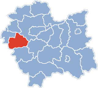
Gmina Wieprz is a rural gmina in Wadowice County, Lesser Poland Voivodeship, in southern Poland. Its seat is the village of Wieprz, which lies approximately 10 kilometres (6 mi) west of Wadowice and 46 km (29 mi) south-west of the regional capital Kraków.

Silesian Foothills are foothills located in Silesian Voivodeship, Poland.

Chocznia is a village in the administrative district of Gmina Wadowice, within Wadowice County, Lesser Poland Voivodeship, in southern Poland. It lies approximately 4 kilometres (2 mi) west of Wadowice and 41 km (25 mi) south-west of the regional capital Kraków.
Gorzeń Dolny is a village in the administrative district of Gmina Wadowice, within Wadowice County, Lesser Poland Voivodeship, in southern Poland. It lies approximately 2 kilometres (1 mi) west of Wadowice and 39 km (24 mi) south-west of the regional capital Kraków.
Jaroszowice is a village in the administrative district of Gmina Wadowice, within Wadowice County, Lesser Poland Voivodeship, in southern Poland. It lies approximately 4 kilometres (2 mi) south-east of Wadowice and 37 km (23 mi) south-west of the regional capital Kraków.
Kaczyna is a village in the administrative district of Gmina Wadowice, within Wadowice County, Lesser Poland Voivodeship, in southern Poland. It lies approximately 8 kilometres (5 mi) south-west of Wadowice and 45 km (28 mi) south-west of the regional capital Kraków.
Ponikiew is a village in the administrative district of Gmina Wadowice, within Wadowice County, Lesser Poland Voivodeship, in southern Poland. It lies approximately 9 kilometres (6 mi) south-west of Wadowice and 45 km (28 mi) south-west of the regional capital Kraków.
Wysoka is a village in the administrative district of Gmina Wadowice, within Wadowice County, Lesser Poland Voivodeship, in southern Poland. It lies approximately 9 kilometres (6 mi) north-east of Wadowice and 30 km (19 mi) south-west of the regional capital Kraków.
Zawadka is a village in the administrative district of Gmina Wadowice, within Wadowice County, Lesser Poland Voivodeship, in southern Poland. It lies approximately 5 kilometres (3 mi) south-west of Wadowice and 41 km (25 mi) south-west of the regional capital Kraków.
Brzezinka is a village in the administrative district of Gmina Andrychów, within Wadowice County, Lesser Poland Voivodeship, in southern Poland. It lies approximately 5 kilometres (3 mi) south of Andrychów, 15 km (9 mi) south-west of Wadowice, and 52 km (32 mi) south-west of the regional capital Kraków.
Inwałd is a village in the administrative district of Gmina Andrychów, within Wadowice County, Lesser Poland Voivodeship, in southern Poland. It lies approximately 5 kilometres (3 mi) east of Andrychów, 8 km (5 mi) west of Wadowice, and 45 km (28 mi) south-west of the regional capital Kraków.

Roczyny is a village in the administrative district of Gmina Andrychów, within Wadowice County, Lesser Poland Voivodeship, in southern Poland. It lies approximately 3 kilometres (2 mi) south-west of Andrychów, 14 km (9 mi) west of Wadowice, and 51 km (32 mi) south-west of the regional capital Kraków.
Rzyki is a village in the administrative district of Gmina Andrychów, within Wadowice County, Lesser Poland Voivodeship, in southern Poland. It lies approximately 7 kilometres (4 mi) south-east of Andrychów, 12 km (7 mi) south-west of Wadowice, and 49 km (30 mi) south-west of the regional capital, Kraków.
Targanice is a village in the administrative district of Gmina Andrychów, within Wadowice County, Lesser Poland Voivodeship, in southern Poland. It lies approximately 6 kilometres (4 mi) south of Andrychów, 16 km (10 mi) south-west of Wadowice, and 53 km (33 mi) south-west of the regional capital Kraków.

Zagórnik is a village in the administrative district of Gmina Andrychów, within Wadowice County, Lesser Poland Voivodeship, in southern Poland. It lies approximately 5 kilometres (3 mi) south-east of Andrychów, 11 km (7 mi) south-west of Wadowice, and 48 km (30 mi) south-west of the regional capital Kraków.
Chrząstowice is a village in the administrative district of Gmina Brzeźnica, within Wadowice County, Lesser Poland Voivodeship, in southern Poland. It lies approximately 3 kilometres (2 mi) west of Brzeźnica, 12 km (7 mi) north-east of Wadowice, and 27 km (17 mi) south-west of the regional capital Kraków.
Dąbrówka is a village in the administrative district of Gmina Stryszów, within Wadowice County, Lesser Poland Voivodeship, in southern Poland.
Witanowice is a village in the administrative district of Gmina Tomice, within Wadowice County, Lesser Poland Voivodeship, in southern Poland. It lies approximately 6 kilometres (4 mi) north-east of Tomice, 7 km (4 mi) north-east of Wadowice, and 32 km (20 mi) south-west of the regional capital Kraków.