
Andrychów is the largest town in Wadowice County, Lesser Poland Voivodeship, Poland. The town is located in the Little Beskids, in the historical region of Lesser Poland, on the river Wieprzówka. It has been situated in the Lesser Poland Voivodeship since 1999, having previously been located in the Bielsko-Biała Voivodeship (1975–1998). Andrychów has an area of 10.34 square kilometres and as of June 2022 it has 18,815 inhabitants.
Wadowice County is a unit of territorial administration and local government (powiat) in Lesser Poland Voivodeship, southern Poland. It came into being on January 1, 1999, as a result of the Polish local government reforms passed in 1998. Its administrative seat is the town of Wadowice, the birthplace of Pope John Paul II, which lies 38 kilometres (24 mi) south-west of the regional capital Kraków. The county also contains the towns of Andrychów, lying 13 km (8 mi) west of Wadowice, and Kalwaria Zebrzydowska, 14 km (9 mi) east of Wadowice.
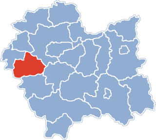
Gmina Andrychów is an urban-rural gmina in Wadowice County, Lesser Poland Voivodeship, in southern Poland. Its seat is the town of Andrychów, which lies approximately 13 kilometres (8 mi) west of Wadowice and 49 km (30 mi) south-west of the regional capital Kraków.
Gmina Wieprz is a rural gmina in Wadowice County, Lesser Poland Voivodeship, in southern Poland. Its seat is the village of Wieprz, which lies approximately 10 kilometres (6 mi) west of Wadowice and 46 km (29 mi) south-west of the regional capital Kraków.
Inwałd is a village in the administrative district of Gmina Andrychów, within Wadowice County, Lesser Poland Voivodeship, in southern Poland. It lies approximately 5 kilometres (3 mi) east of Andrychów, 8 km (5 mi) west of Wadowice, and 45 km (28 mi) south-west of the regional capital Kraków.

Roczyny is a village in the administrative district of Gmina Andrychów, within Wadowice County, Lesser Poland Voivodeship, in southern Poland. It lies approximately 3 kilometres (2 mi) south-west of Andrychów, 14 km (9 mi) west of Wadowice, and 51 km (32 mi) south-west of the regional capital Kraków.
Rzyki is a village in the administrative district of Gmina Andrychów, within Wadowice County, Lesser Poland Voivodeship, in southern Poland. It lies approximately 7 kilometres (4 mi) south-east of Andrychów, 12 km (7 mi) south-west of Wadowice, and 49 km (30 mi) south-west of the regional capital, Kraków.

Sułkowice is a village in the administrative district of Gmina Andrychów, within Wadowice County, Lesser Poland Voivodeship, in southern Poland. It lies approximately 5 kilometres (3 mi) south of Andrychów, 12 km (7 mi) south-west of Wadowice, and 50 km (31 mi) south-west of the regional capital Kraków.

Targanice is a village in the administrative district of Gmina Andrychów, within Wadowice County, Lesser Poland Voivodeship, in southern Poland. It lies approximately 6 kilometres (4 mi) south of Andrychów, 16 km (10 mi) south-west of Wadowice, and 53 km (33 mi) south-west of the regional capital Kraków.

Zagórnik is a village in the administrative district of Gmina Andrychów, within Wadowice County, Lesser Poland Voivodeship, in southern Poland. It lies approximately 5 kilometres (3 mi) south-east of Andrychów, 11 km (7 mi) south-west of Wadowice, and 48 km (30 mi) south-west of the regional capital Kraków.
Chumiętki is a village in the administrative district of Gmina Krobia, within Gostyń County, Greater Poland Voivodeship, in west-central Poland. It lies approximately 2 kilometres (1 mi) west of Krobia, 12 km (7 mi) south of Gostyń, and 69 km (43 mi) south of the regional capital Poznań.
Ciołkowo is a village in the administrative district of Gmina Krobia, within Gostyń County, Greater Poland Voivodeship, in west-central Poland. It lies approximately 5 kilometres (3 mi) south of Krobia, 16 km (10 mi) south of Gostyń, and 74 km (46 mi) south of the regional capital Poznań.
Gogolewo is a village in the administrative district of Gmina Krobia, within Gostyń County, Greater Poland Voivodeship, in west-central Poland. It lies approximately 8 kilometres (5 mi) south of Krobia, 18 km (11 mi) south of Gostyń, and 76 km (47 mi) south of the regional capital Poznań.
Karzec is a village in the administrative district of Gmina Krobia, within Gostyń County, Greater Poland Voivodeship, in west-central Poland. It lies approximately 7 kilometres (4 mi) south-west of Krobia, 16 km (10 mi) south-west of Gostyń, and 72 km (45 mi) south of the regional capital Poznań.
Posadowo is a village in the administrative district of Gmina Krobia, within Gostyń County, Greater Poland Voivodeship, in west-central Poland. It lies approximately 5 kilometres (3 mi) east of Krobia, 13 km (8 mi) south of Gostyń, and 71 km (44 mi) south of the regional capital Poznań.
Przyborowo is a village in the administrative district of Gmina Krobia, within Gostyń County, Greater Poland Voivodeship, in west-central Poland. It lies approximately 9 kilometres (6 mi) south-west of Krobia, 20 km (12 mi) south of Gostyń, and 76 km (47 mi) south of the regional capital Poznań.
Sułkowice is a village in the administrative district of Gmina Krobia, within Gostyń County, Greater Poland Voivodeship, in west-central Poland. It lies approximately 5 kilometres (3 mi) east of Krobia, 10 km (6 mi) south of Gostyń, and 68 km (42 mi) south of the regional capital Poznań.
Żychlewo is a village in the administrative district of Gmina Krobia, within Gostyń County, Greater Poland Voivodeship, in west-central Poland. It lies approximately 2 kilometres (1 mi) north of Krobia, 10 km (6 mi) south of Gostyń, and 67 km (42 mi) south of the regional capital Poznań.

Tuchlino is a village in the administrative district of Gmina Sierakowice, within Kartuzy County, Pomeranian Voivodeship, in northern Poland. It lies approximately 5 kilometres (3 mi) south-west of Sierakowice, 23 km (14 mi) west of Kartuzy, and 51 km (32 mi) west of the regional capital Gdańsk.

Rożental is a village in the administrative district of Gmina Pelplin, within Tczew County, Pomeranian Voivodeship, in northern Poland. It lies approximately 2 kilometres (1 mi) south-west of Pelplin, 21 km (13 mi) south of Tczew, and 51 km (32 mi) south of the regional capital Gdańsk. It is located within the ethnocultural region of Kociewie in the historic region of Pomerania.


