
Sardinia is the second-largest island in the Mediterranean Sea, after Sicily, and one of the 20 regions of Italy. It is located west of the Italian Peninsula, north of Tunisia and immediately south of the French island of Corsica.
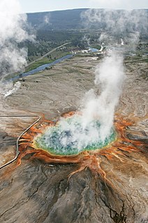
A hot spring, hydrothermal spring, or geothermal spring is a spring produced by the emergence of geothermally heated groundwater onto the surface of the Earth. The groundwater is heated either by shallow bodies of magma or by circulation through faults to hot rock deep in the Earth's crust. In either case, the ultimate source of the heat is radioactive decay of naturally occurring radioactive elements in the Earth's mantle, the layer beneath the crust.

A spring is a point of exit at which groundwater from an aquifer flows out on top of Earth's crust (pedosphere) and becomes surface water. It is a component of the hydrosphere. Springs have long been important for humans as a source of fresh water, especially in arid regions which have relatively little annual rainfall.

White Deer Creek is a tributary of the West Branch Susquehanna River in Centre County and Union County, in Pennsylvania, in the United States. It is approximately 28 miles (45 km) long and flows through Miles Township in Centre County and Hartley Township, Lewis Township, West Buffalo Township, and White Deer Township in Union County. The watershed of the creek has an area of 45.1 square miles (117 km2). Parts of the creek are designated as impaired. The creek's discharge near White Deer can be as low as 3 cubic feet per second (0.085 m3/s) or as high as 169 cubic feet per second (4.8 m3/s).
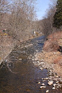
Harveys Creek is a tributary of the Susquehanna River in Luzerne County, Pennsylvania, in the United States. It is approximately 14.5 miles (23.3 km) long and flows through Harveys Lake, Lake Township, Lehman Township, Jackson Township, and Plymouth Township. The creek's watershed has an area of 46.3 square miles (120 km2). The creek has four named tributaries, which are known as Bear Hollow Creek, Paint Spring Run, Pikes Creek, and East Fork Harveys Creek. The watershed is designated as a High-Quality Coldwater Fishery and a Migratory Fishery above Pikes Creek and as a Coldwater Fishery and a Migratory Fishery below it. The creek's source is Harveys Lake, the largest natural lake in Pennsylvania.

Big Wapwallopen Creek is a tributary of the Susquehanna River in Luzerne County, Pennsylvania, in the United States. It is approximately 23 miles (37 km) long and flows through Bear Creek Township, Fairview Township, Rice Township, Wright Township, Dorrance Township, Hollenback Township, Nescopeck Township, and Conyngham Township. The watershed of the creek has an area of 53.2 square miles (138 km2). The creek has three named tributaries: Balliet Run, Watering Run, and Bow Creek. The creek is designated as a Coldwater Fishery and a Migratory Fishery and is also Class A Wild Trout Waters for part of its length. However, a portion is considered to be impaired by organic enrichment and/or low levels of dissolved oxygen and its pH ranges from moderately acidic to slightly alkaline.
Oliena is a commune in the province of Nuoro, Sardinia, Italy.

Chillisquaque Creek is a tributary of the West Branch Susquehanna River in Montour County and Northumberland County, in Pennsylvania, in the United States. It is approximately 20.2 miles (32.5 km) long and flows through Derry Township, Washingtonville, and Liberty Township in Montour County and East Chillisquaque Township and West Chillisquaque Township in Northumberland County. The watershed of the creek has an area of 112 square miles (290 km2). Agricultural impacts have caused most of the streams in the watershed of the creek to be impaired. Causes of impairment include sedimentation/siltation and habitat alteration. The average annual discharge of the creek between 1980 and 2014 ranged from 48.2 to 146.0 cubic feet per second. Its watershed mainly consists of rolling agricultural land. The creek's channel flows through rock formations consisting of sandstone and shale. It is a warmwater stream.

Buffalo Creek is a tributary of the West Branch Susquehanna River in Union County, Pennsylvania, in the United States. It is approximately 28.5 miles (45.9 km) long and flows through Hartley Township, Lewis Township, West Buffalo Township, Mifflinburg, Buffalo Township, Kelly Township, and Lewisburg. Its watershed has an area of 134 square miles (350 km2). It is in the ridge-and-valley province of the Appalachian Mountains. Some streams and parts of streams in the creek's watershed are high-quality cold-water fisheries. There are ten types of rock formations and eight types of soil series in the watershed. The forests in the Buffalo Creek watershed are mostly deciduous hardwood, hemlock, and pine.

Mahanoy Creek is a 51.6-mile-long (83.0 km) tributary of the Susquehanna River in Northumberland and Schuylkill counties, Pennsylvania. There are at least 35 sources of acid mine drainage in the creek's watershed. Anthracite was mined in the upper part of the Mahanoy Creek watershed in the 19th and 20th centuries. Mahanoy Creek's tributaries include Schwaben Creek, Zerbe Run, Little Mahanoy Creek, Shenandoah Creek, and North Mahanoy Creek. Little Mahanoy Creek and Schwaben Creek are two streams in the watershed that are unaffected by acid mine drainage. Schwaben Creek has a higher number and diversity of fish species than the main stem.

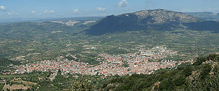
The Supramonte is a mountain range located in central-eastern Sardinia, Italy. It lies northeast of the Gennargentu massif, traveling eastwards until it reaches the Tyrrhenian Sea at the Gulf of Orosei. It has an area of about 35,000 hectares, encompassing most of the territories of the comuni (municipalities) of Baunei, Dorgali, Oliena, Orgosolo and Urzulei. The populated areas of these comuni lie at the borders of the Supramonte, which, for the most part, is a largely uninhabited area of sharp limestone cliffs and deep, lush canyons.

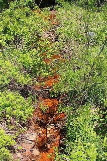
Hammam Maskhoutine (Arabic: حمام المسخوطين, English: "bath of the damned") is a thermal complex located in Hammam Debagh, of Guelma Province, Algeria. The dramatic, multicolored travertine walls of the spring have attracted attention from locals and tourists alike since the era of the Roman Empire.

Little Mahanoy Creek is a 7.5 miles (12.1 km) tributary of Mahanoy Creek in Schuylkill County, Pennsylvania. It starts in the borough of Frackville and joins Mahanoy Creek in the borough of Gordon. Its one named tributary is Rattling Run. The creek's watershed has an area of 11.6 square miles (30 km2). Its watershed is not affected by mining. Compounds found in the waters of the creek include nitrogen, phosphorus, orthophosphates, phosphates, nitrates, and ammonia.

South Branch Roaring Creek is a tributary of Roaring Creek in Columbia County and Northumberland County, Pennsylvania, in the United States. It is approximately 16.8 miles (27.0 km) long. The upper reaches of the creek are located in Weiser State Forest, between Big Mountain and Little Mountain. The creek is home to some trout and is considered a high-quality coldwater fishery. The Chemung Formation occurs in the creek's watershed. The watershed is 25 square miles in area.

Coles Creek is a tributary of Fishing Creek, in Columbia County, Pennsylvania and Sullivan County, Pennsylvania, in the United States. It is 6.0 miles (9.7 km) long and is the first named tributary of Fishing Creek downstream of where East Branch Fishing Creek and West Branch Fishing Creek meet to form Fishing Creek. The creek is on the edge of Columbia County and parts of its watershed are in Luzerne County.

Toby Creek is a tributary of the Susquehanna River in Luzerne County, Pennsylvania, in the United States. It is approximately 10.5 miles (16.9 km) long and flows through Dallas Township, Dallas, Kingston Township, Courtdale, Luzerne, Pringle, Kingston, Edwardsville, and Larksville. The watershed of the creek has an area of 36.5 square miles (95 km2). The entire drainage basin is designated as a Migratory Fishery and parts are designated as either a Coldwater Fishery, a Warmwater Fishery, or a Trout Stocking Fishery. The creek has two named tributaries: Huntsville Creek and Trout Brook. It is said to show "some degraded conditions", but does not experience severe pollution and is not considered to be impaired. The creek is piped underground in Pringle, but resurfaces in Edwardsville.
Nanticoke Creek is a tributary of the Susquehanna River in Luzerne County, Pennsylvania, in the United States. It is approximately 4.4 miles (7.1 km) long and flows through Hanover Township and Nanticoke. The watershed of the creek has an area of 7.57 square miles (19.6 km2). The creek has one named tributary, which is known as Espy Run. Nanticoke Creek impaired by pH and metals due to abandoned mine drainage. Abandoned mine drainage discharges in the creek's watershed include the Truesdale Mine Discharge and the Askam Borehole. The creek is located in the Northern Middle Anthracite Field and is in the Anthracite Valley Section of the ridge and valley physiographic province. The main rock formations in the watershed include the Mauch Chunk Formation, the Pottsville Group, and the Llewellyn Formation. The surficial geology consists of coal dumps, surface mining land, alluvium, Wisconsinan Outwash, Wisconsinan Till, urban land, and bedrock.

Spring Brook is a tributary of the Lackawanna River in Lackawanna County and Luzerne County, in Pennsylvania, in the United States. It is approximately 17 miles (27 km) long and flows through Covington Township, Spring Brook Township, and Moosic in Lackawanna County and Pittston Township in Luzerne County. The watershed of the stream has an area of 57.2 square miles (148 km2). It is designated as a High-Quality Coldwater Fishery and a Migratory Fishery above Interstate 476 and as a Coldwater Fishery and a Migratory Fishery below it. A section is also designated as Class A Wild Trout Waters. The stream's tributaries include Panther Creek, Plank Bridge Creek, Rattlesnake Creek, Green Run, Monument Creek, and Covey Swamp Creek. It has a relatively high level of water quality and is very slightly acidic, with a pH of 6.4 to 6.9.
Roaring Brook is a tributary of the Lackawanna River in Lackawanna County, Pennsylvania, in the United States. It is approximately 21 miles (34 km) long and flows through Covington Township, Madison Township, Moscow, Roaring Brook Township, Elmhurst Township, Dunmore, and Scranton. The watershed of the stream has an area of 56.3 square miles (146 km2). Its named tributaries include Little Roaring Brook, Rock Bottom Creek, White Oak Run, Van Brunt Creek, Bear Brook, and East Branch Roaring Brook. It has a high level of water quality for much of its length. However, it is affected by abandoned mining land, stormwater, and other impacts in its lower reaches. Reservoirs in the watershed include the Hollister Reservoir, the Elmhurst Reservoir, and others. The stream also flows through the Nay Aug Gorge and passes over the Nay Aug Falls, which are on the National Register of Geologic Landmarks. It flows through a concrete channel in its lower reaches. The topography of the watershed contains rolling hills in its upper reaches and the mountainous land of the Moosic Mountains in its lower reaches.

Residential water use includes all indoor and outdoor uses of drinking quality water at single-family and multifamily dwellings. These uses include a number of defined purposes such as flushing toilets, washing clothes and dishes, showering and bathing, drinking, food preparation, watering lawns and gardens, and maintaining swimming pools. Some of these end uses are detectable while others are more difficult to gauge.
