A local government is a form of public administration which, in a majority of contexts, exists as the lowest tier of administration within a given state. The term is used to contrast with offices at state level, which are referred to as the central government, national government, or federal government and also to supranational government which deals with governing institutions between states. Local governments generally act within powers delegated to them by legislation or directives of the higher level of government. In federal states, local government generally comprises the third tier of government, whereas in unitary states, local government usually occupies the second or third tier of government, often with greater powers than higher-level administrative divisions.

The subdivisions of England constitute a hierarchy of administrative divisions and non-administrative ceremonial areas.

For local government purposes, Scotland is divided into 32 areas designated as "council areas", which are all governed by single-tier authorities designated as "councils". They have the option under the Local Government (Scotland) Act 1997 of being known as a "comhairle" when opting for a Gaelic name; only Comhairle nan Eilean Siar has chosen this option, whereas the Highland Council has adopted its Gaelic form alongside its English equivalent informally.

Ankole, was a traditional Bantu kingdom in Uganda. The kingdom is located in south-western Uganda, east of Lake Edward. It was ruled by a monarch known as the Mugabe or Omugabe. The kingdom was formally abolished in 1967 by the government of President Milton Obote, and since then, the kingdom has not been restored officially. The people of Ankole are called Banyankole in Runyankole language, a Bantu language.
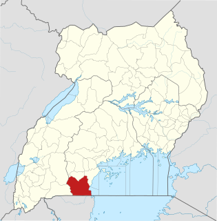
Rakai District is a district in the Central Region of Uganda. The town of Rakai is the site of the district's headquarters.

A Local Council (LC) is a form of local elected government within the districts of Uganda.

The Local Government Act 1894 was an Act of the Parliament of the United Kingdom that reformed local government in England and Wales outside the County of London. The Act followed the reforms carried out at county level under the Local Government Act 1888. The 1894 legislation introduced elected councils at district and parish level.

The Local Government Act 1933 was an Act of the Parliament of the United Kingdom that consolidated and revised existing legislation that regulated local government in England and Wales. It remained the principal legislation regulating local government until the Local Government Act 1972 took effect in 1974.
The wards and electoral divisions in the United Kingdom are electoral districts at sub-national level represented by one or more councillors. The ward is the primary unit of English electoral geography for civil parishes and borough and district councils, electoral ward is the unit used by Welsh principal councils, while the electoral division is the unit used by English county councils and some unitary authorities. Each ward/division has an average electorate of about 5,500 people, but ward-population counts can vary substantially. As at the end of 2014 there were 9,456 electoral wards/divisions in the UK.

Amolatar District is a district in Northern Uganda. Like many other Ugandan districts, it is named after its main municipal and administrative centre, Amolatar Town.

Lands administrative divisions of Australia are the cadastral divisions of Australia for the purposes of identification of land to ensure security of land ownership. Most states term these divisions as counties, parishes, hundreds, and other terms. The eastern states of Queensland, New South Wales, Victoria and Tasmania were divided into counties and parishes in the 19th century, although the Tasmanian counties were renamed land districts in the 20th century. Parts of South Australia (south-east) and Western Australia (south-west) were similarly divided into counties, and there were also five counties in a small part of the Northern Territory. However South Australia has subdivisions of hundreds instead of parishes, along with the Northern Territory, which was part of South Australia when the hundreds were proclaimed. There were also formerly hundreds in Tasmania. There have been at least 600 counties, 544 hundreds and at least 15,692 parishes in Australia, but there are none of these units for most of the sparsely inhabited central and western parts of the country.

The following outline is provided as an overview of and topical guide to Uganda:

Nsangi is a town in the Central Region of Uganda. It is one of the urban centers in Wakiso District.
Kimwanyi is a neighborhood in Kira Municipality, Wakiso District, in the Buganda Region of Uganda. Kimwanyi also refers to Kimwanyi Parish, in Kira sub-county, Kyaddondo County, Wakiso District. It is one of the six parishes (wards) of Kira Municicipality, namely; Kimwanyi, Kira, Kyaliwajjala, Kireka, Bweyogerere and Kirinnya.
Kijabijo is a neighborhood in Kira Town, in Wakiso District in the Buganda Region of Uganda.