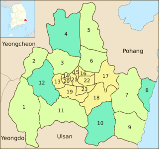
Eup
Angang-eup (No.4) is the second-largest subdivision of Gyeongju City. Its 139 square kilometers are home to about 35,700 people. Situated next to Gangdong-myeon in the city's northern tip, it is a significant town in its own right. Angang Station is a regular stop on the Donghae Nambu Line. The town center lies on the Hyeongsan River, near where it meets the small Chilpyeongcheon stream.
Gampo-eup (No.8) also contains a piece of Gyeongju National Park: the Daebon section which covers the shoreline near the watery grave of King Munmu. 7,900 people live in Gampo-eup, served by three elementary schools and a joint middle-high school. Important local products include persimmons as well as anchovies, seaweed, and squid.
Oedong-eup (No.10) is linked by road and rail to the neighboring metropolis of Ulsan. Thanks to this, it has been a center of the development of Gyeongju's automotive parts industry. Three industrial complexes are located here. Roughly 18,300 people live in Oedong-eup. This population is served by six elementary schools, a middle school, and a high school.
Geoncheon-eup (No.12)
Myeon
Sannae-myeon (No.1) - its name means "within the mountains." Sannae-myeon covers 142.25 km2 and is home to 3,695 people. It has an elementary school and a joint middle-high school.
Seo-myeon (No.2) - its name means "Western myeon." An elementary school and middle school are located in Seo-myeon, serving a local population of 4,400.
Hyeongok-myeon (No.3) played a significant role in the history of Chondogyo, a Korean religion. Choe Je-u, the founder of Chondogyo, used Gumi Mountain as the base for his missionary activities in the early 1860s. The Gumi Mountain area is now part of Gyeongju National Park. Two elementary schools and a high school are located in Hyeongok-myeon, serving a population of 11,500.
Gangdong-myeon (No.5) its name means "east of the river," although in fact much of it lies north of the Hyeongsan River. It is home to 9,000 people. Two elementary schools are located here, as is Uiduk University. The Yangdong Folk Village, a tourist attraction preserving the culture of the late Joseon Dynasty, also lies within Gangdong-myeon.
Cheonbuk-myeon (No.6) is home to about 6,100 people. It is home to two elementary schools, as well as Silla Industrial High School. The area is strongly agricultural. In addition to grain crops, apples are widely cultivated.
Yangbuk-myeon (No.7) stretches from central Gyeongju to the coast of the Sea of Japan (East Sea). Despite its large area, it is home to only 4,500 people. This is in part because much of it is taken up by the Toham-san section of Gyeongju National Park. Yangbuk-myeon is home to two elementary schools, a high school, and a joint elementary-middle school.
Yangnam-myeon (No.9) is the southernmost of the three coastal subdivisions of Gyeongju. The Wolseong Nuclear Power Plant is located on the coast. It provides about 5% of South Korea's electricity. About 6,800 people live in this district.
Naenam-myeon (No.11)

Gyeongju, historically known as Seorabeol, is a coastal city in the far southeastern corner of North Gyeongsang Province in South Korea. It is the second largest city by area in the province after Andong, covering 1,324 km2 (511 sq mi) with a population of 264,091 people Gyeongju is 370 km (230 mi) southeast of Seoul, and 55 km (34 mi) east of Daegu. The city borders Cheongdo and Yeongcheon to the west, Ulsan to the south and Pohang to the north, while to the east lies the coast of the Sea of Japan. Numerous low mountains—outliers of the Taebaek range—are scattered around the city.

The Hyeongsan River is a river in southeastern South Korea. It flows from Baeyanggol Valley (배양골), Wolpyeong-ri (월평리/月坪里), Dudong-myeon (두동면/斗東面), Ulju County in Ulsan to the Sea of Japan, covering a distance of about 62 km. The Hyeongsan watershed covers roughly 1,167 km².
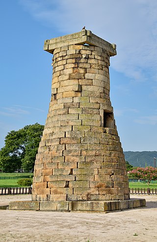
Tourism in Gyeongju is a major industry and defining feature of Gyeongju, South Korea. Gyeongju is a major cultural site and tourist destination for South Koreans and foreigners with about 8 to 9 million visitors annually. A great deal of this is due to the city's status as a center of Silla heritage, derived from its former role as the capital of that ancient kingdom.

Gangdong-myeon is a myeon or a township of Gyeongju city in North Gyeongsang Province, South Korea. It is bordered by Pohang on the east and north, Cheonbuk-myeon on the south and Angang-eup on the west. In 2006 its population was 8,705 people, and its area is approximately 81.48 sq kilometers. Its name means "east of the river" although in fact much of it lies north of the Hyeongsan River.
The Angang Sewage Disposal Plant is a sewage treatment plant located in the city of Gyeongju, North Gyeongsang province, South Korea. It began operating in April, 2005 by the co-investment of the Government of North Gyeongsang and Gyeongju City with a fund of 44,300,000,000 won to install the facilities to prevent the pollution of Hyeongsan River which is a main water source for Gyeongju and Pohang residents. The plant is located on a spacious site with 39,000 m2 in Homyeong-ri, Gangdong-myeon where nature friendly facilities are also built to provide recreational venues for the locals. Through intercepting sewer pipes with a 56.1 km length and 14 pumping stations, the plant has a capacity in dealing with 18,000 tone of domestic sewage per day that comes from Angang-eup, and Gangdong-myeon in Gyeongju. The facilities have high-powered disposal equipments which are developed by related industrial companies to maintain the final discharging water as the first or second degree water in quality, so that it is used as river maintenance flow and agricultural water in case a drought occurs.

Gampo-eup is an eup or a town of Gyeongju in South Korea. It contains part of Gyeongju National Park: the Daebon section which covers the shoreline near Daewangnueng, the watery grave of King Munmu of the Silla kingdom. 7,132 people live in Gampo-eup, served by two elementary schools and a joint middle-high school. Important local products include persimmons as well as anchovies, seaweed, and squid.

Angang-eup is an eup, or town, and the second-largest subdivision of Gyeongju City. Its 139 square kilometers are home to about 33,300 people and is served by six elementary schools and two joint middle-high schools. Situated next to Gangdong-myeon in the city's northern tip, it is a significant town in its own right. Angang Station is a regular stop on the Donghae Nambu Line. The town center lies on the Hyeongsan River, near where it meets the small Chilpyeongcheon stream. Important local products include rice, apples, and grapes.

Oedong-eup is an eup or a town in the subdivision of the Gyeongju City, North Gyeongsang province, South Korea. Its 139 square kilometers are home to about 17, 500 people. It is linked by road and rail to the neighboring metropolis of Ulsan. Due to the feature, the town has been a center of the development of Gyeongju's automotive parts industry. Three industrial complexes are located here. This population is served by six elementary schools, a middle school, and a high school

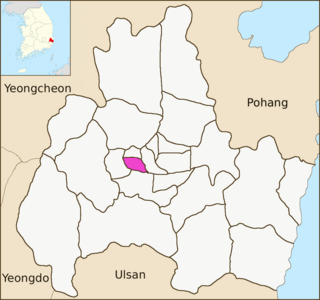
Seo-myeon is a myeon or a township in the subdivision of the Gyeongju City, North Gyeongsang province, South Korea. It is bordered by its neighborhoods including Hyeongok-myeon and Geoncheon-eup on the east, Sannae-myeon on the south and Yeongcheon City on the west and north. Its 52.12 square kilometers are home to about 4,166 people. This population is served by one elementary school and one joint middle school.

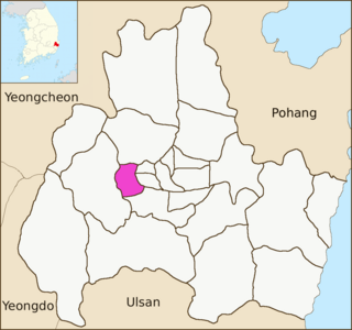
Hyeongok-myeon is a myeon or a township in the administrative subdivisions of Gyeongju City, North Gyeongsang province, South Korea. It is bordered by Hyeongsan River, Cheonbuk-myeon and Yonghwang-dong to the east, Bodeok-dong to the south, Geoncheon-eup to the southwest, Seo-myeon to the west and Angang-eup to the north. It has an area of 55.74 square kilometers and is home to 13,658 people. This population is served by three elementary schools, one middle school and one high school.

Cheonbuk-myeon is a myeon, or township, in the administrative subdivisions of the Gyeongju City, North Gyeongsang province, South Korea. It is bordered by Pohang city to the east, Bodeok-dong to the south, Angang-eup and Hyeongok-myeon to the Hyeongsan River to the west and Gangdong-myeon to the north. Its 58.15 square kilometres (22.45 sq mi) are home to about 6,140 people. There are two elementary schools and one high school.

Munmudaewang-myeon is a myeon or a township in the administrative subdivisions of the Gyeongju City, North Gyeongsang province, South Korea. It is bordered by Gampo-eup and Sea of Japan on the east, Yangnam-myeon on the south, Bulguk-dong, Bodeok-dong and Oedong-eup on the west and Ocheon-eup and Janggi-myeon of the Pohang city on the north. Its 120.06 square kilometers are home to about 4,558 people. This population is served by one joint elementary-middle school.

Yangnam-myeon is a myeon or a township in the administrative subdivisions of the Gyeongju City, North Gyeongsang province, South Korea. It is bordered by the Sea of Japan on the east, the Ulju County of Ulsan Metropolitan City on the south, Oedong-eup on the west and Yangbuk-myeon on the north. Its 85.06 square kilometers are home to about 7,131 people. The Wolseong Nuclear Power Plant is situated in the myeon.

Naenam-myeon is a myeon or a township in the administrative subdivisions of the Gyeongju City, North Gyeongsang province, South Korea. It is bordered by Geumo Mountains on the east, Jusa Mountains on the south. Its 122.05 square kilometers are home to about 6,142 people. This population is served by one elementary school and one high school.
Seondo-dong is an administrative dong or neighbourhood in the administrative subdivisions of the Gyeongju City, North Gyeongsang province, South Korea. It consists of four legal dongs such as Seoak-dong, Chunghyo-dong, Hyohyeon-dong, and Gwangmyeong-dong. It is bordered by Seonggeon-dong and Tapjeong-dong on the east, Geoncheon-eup on the south and west and Hyeongok-myeon on the north. Its 28.00 square kilometers are home to about 13,587 people. This population is served by an elementary school, a middle school and a joint middle-high school, two high schools, a junior college, a university and a vocational school.

Seonggeon-dong is an administrative dong or a neighbourhood in the administrative subdivisions of the Gyeongju City, North Gyeongsang province, South Korea. It consists of four legal dongs including Seonggeon-dong and Seokjang-dong. It is bordered by Dongcheon-dong on the east, Geoncheon-eup on the west and Jungbu-dong on the south and Hyeongok-myeon on the north. Its 6.42 square kilometers are home to about 18,219 people. The Gyeongju branch campus of Dongguk University is situated in the district and it has an elementary school and a high school

Bodeok-dong is an administrative dong or a neighbourhood in the administrative subdivisions of the Gyeongju City, North Gyeongsang province, South Korea. It consists of seven legal dong including Cheongun-dong, Sinpyeong-dong, Bukgun-dong, Sogok-dong, Deok-dong, Hwangnyeong-dong and Amgok-dong
Wolseong-dong is an administrative dong or a neighbourhood in the administrative subdivisions of the Gyeongju City, North Gyeongsang province, South Korea. It consists of nine legal dong including Inwang-dong, Gyo-dong, Dongbang-dong, Doji-dong, Namsan-dong, Pyeong-dong, Guhwang-dong, Bomun-dong and Baeban-dong

Hwangnam-dong is a dong or a neighbourhood of the Gyeongju City, North Gyeongsang province, South Korea. It is bordered by Dodong-dong on the east, Tapjeong-dong on the west, Naenam-myeon on the south and Jungang-dong on the north. Its 20.5 square kilometers are home to about 8,885 people. It is both an administrative and legal dong.
Jungbu-dong is a dong or a neighbourhood of the Gyeongju City, North Gyeongsang province, South Korea. It is bordered by Songdong-dong and Hwango-dong on the east, Seonggeon-dong on the west, Hwangnam-dong on the south and Hwangseong-dong on the north. Its 0.93 square kilometers are home to about 6,894 people. It is an administrative dong that consists of five legal dongs such as Seobu-dong, Dongbu-dong, Bukbu-dong, Noseo-dong, and Nodong-dong.