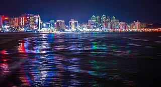
Pohang is a city in the province of North Gyeongsang, South Korea, and a main seaport in the Daegu-Gyeongbuk region. The built-up area of Pohang is located on the alluvium of the mouth of the Hyeongsan River. The city is divided into two wards (gu), Buk-gu or Northern Ward and Nam-gu or Southern Ward.

Yeongju is a city in the far north region of North Gyeongsang province in South Korea, covering 668.84 km2 with a population of 113,930 people according to the 2008 census. The city borders Bonghwa county to the east, Danyang county of North Chungcheong province to the west, Andong city and Yecheon county to the south, and Yeongwol county of Gangwon province to the north.
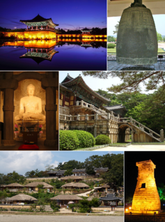
Gyeongju, historically known as Seorabeol, is a coastal city in the far southeastern corner of North Gyeongsang Province in South Korea. It is the second largest city by area in the province after Andong, covering 1,324 km2 (511 sq mi) with a population of 264,091 people Gyeongju is 370 km (230 mi) southeast of Seoul, and 55 km (34 mi) east of Daegu. The city borders Cheongdo and Yeongcheon to the west, Ulsan to the south and Pohang to the north, while to the east lies the coast of the Sea of Japan. Numerous low mountains—outliers of the Taebaek range—are scattered around the city.

The Donghae Nambu Line is a railway line connecting Busan to Pohang in South Korea. The line runs along South Korea's east coast. On December 30, 2016, it was merged into Donghae Line.

The Daegu Line is a railway line in South Korea. The line connects Gacheon station on the Gyeongbu Line in Daegu to Yeongcheon on the Jungang Line. The line is served by frequent passenger trains between Seoul, Dongdaegu, and Gyeongju, Pohang and Ulsan.
Sangju is a city in North Gyeongsang Province, central South Korea. Although Sangju is rather rural, it is very old and was once a key city. Along with Gyeongju, it gives rise to half of the name of the Gyeongsang provinces. Sangju is nicknamed Sam Baek, or "Three Whites", referring to three prominent agricultural products rice, silkworm cocoons, and dried persimmons from the area.

Bonghwa County (Bonghwa-gun) is a county in North Gyeongsang Province, South Korea. It lies inland, at the northern edge of the province, and borders Gangwon province to the north. To the east it is bounded by Yeongyang and Uljin counties, to the south by Andong, and to the west by Yeongju. The county is ringed by the Taebaek and Sobaek Mountains, the highest of which is Taebaek-san itself, at more than 1500 meters above sea level. Because of this mountainous inland location, Bonghwa has a colder climate than most of the province, with an average annual temperature of 10 °C (50 °F).

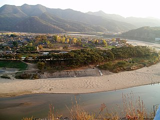
The Hyeongsan River is a river in southeastern South Korea. It flows from Baeyanggol Valley (배양골), Wolpyeong-ri (월평리/月坪里), Dudong-myeon (두동면/斗東面), Ulju County in Ulsan to the Sea of Japan, covering a distance of about 62 km. The Hyeongsan watershed covers roughly 1,167 km².
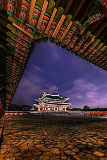
Korean architecture refers to an architectural style that developed over centuries in Korea. Throughout the history of Korea, various kingdoms and royal dynasties have developed a unique style of architecture with influences from Buddhism and Korean Confucianism.
The primary subdivisions of Gyeongju in South Korea consist of 4 eup, 8 myeon, and 11 dong. These units are the same into which all of the cities and counties of South Korea are divided. The dong units occupy the area of the city center, which was formerly occupied by Gyeongju-eup. Eup refers to a substantial village, whereas the myeon are more rural. The current divisions are as follows, using the numbers given on the map:
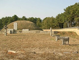
Tourism in Gyeongju is a major industry and defining feature of Gyeongju, South Korea. Gyeongju is a major cultural site and tourist destination for South Koreans and foreigners with about 8 to 9 million visitors annually. A great deal of this is due to the city's status as a center of Silla heritage, derived from its former role as the capital of that ancient kingdom.
The Hahoe Folk Village is a traditional village from the Joseon Dynasty, located in Andong, Gyeongsangbuk-do, South Korea. The 'Ha' is short for river and 'hoe' means to 'turn around, return, come back.

Yangdong Folk Village is a traditional yangban village from the Joseon dynasty. The village is located in Gangdong-myeon, sixteen kilometers northeast of Gyeongju, Gyeongsangbuk-do, South Korea, along the Hyeongsan River. Mt. Seolchang stands to the north of the village. The village is designated as Important Folklore Materials No. 189 by the South Korean government.
The Angang Sewage Disposal Plant is a sewage treatment plant located in the city of Gyeongju, North Gyeongsang province, South Korea. It began operating in April, 2005 by the co-investment of the Government of North Gyeongsang and Gyeongju City with a fund of 44,300,000,000 won to install the facilities to prevent the pollution of Hyeongsan River which is a main water source for Gyeongju and Pohang residents. The plant is located on a spacious site with 39,000 m2 in Homyeong-ri, Gangdong-myeon where nature friendly facilities are also built to provide recreational venues for the locals. Through intercepting sewer pipes with a 56.1 km length and 14 pumping stations, the plant has a capacity in dealing with 18,000 tone of domestic sewage per day that comes from Angang-eup, and Gangdong-myeon in Gyeongju. The facilities have high-powered disposal equipments which are developed by related industrial companies to maintain the final discharging water as the first or second degree water in quality, so that it is used as river maintenance flow and agricultural water in case a drought occurs.

Cheonbuk-myeon is a ;;myeon;; or a township in the administrative subdivisions of the Gyeongju City, North Gyeongsang province, South Korea. It is bordered by Pohang city to the east, Bodeok-dong to the south, Angang-eup and Hyeongok-myeon to the Hyeongsan River to the west and Gangdong-myeon to the north. Its 58.15 square kilometres (22.45 sq mi) are home to about 6,140 people. There are two elementary schools and one high school.

Munmudaewang-myeon is a myeon or a township in the administrative subdivisions of the Gyeongju City, North Gyeongsang province, South Korea. It is bordered by Gampo-eup and Sea of Japan on the east, Yangnam-myeon on the south, Bulguk-dong, Bodeok-dong and Oedong-eup on the west and Ocheon-eup and Janggi-myeon of the Pohang city on the north. Its 120.06 square kilometers are home to about 4,558 people. This population is served by one joint elementary-middle school.
Daegu-Gyeongbuk or Taegu-Kyŏngbuk is the compound word of Daegu and Gyeongbuk, and indicates both administrative regions in South Korea. The region usually forms the similar political, economic, and cultural area. Daegu is an independent city from Gyeongsangbuk-do and has the same administrative status with its mother province. Both have their separate local governments reporting directly to the national government.
National Route 31 is a national highway in South Korea connects Gijang, Busan to Singosan, Anbyeon. Due to the separation of Korean peninsula, it de facto ends in Yanggu It established on 31 August 1971.
National Route 14 is a national highway in South Korea connects Geoje to Pohang. It established on 31 August 1971.