Cheonbuk-myeon | |
|---|---|
myeon | |
| Korean transcription(s) | |
| • Hangul | 천북면 |
| • Hanja | 川北面 |
| • Revised Romanization | Cheonbuk-myeon |
| • McCune–Reischauer | Ch'ŏnpuk-myŏn |
 | |
 Cheonbuk-myeon | |
| Coordinates: 35°54′15″N129°16′29″E / 35.90403°N 129.27461°E | |
| Country | South Korea |
| Region | Gyeongju |
| Administrative divisions | 17 administrative ri (9 legal ri), 74 ban |
| Government | |
| • Type | Gyeongju City |
| Area | |
• Total | 58.15 km2 (22.45 sq mi) |
| Population (2006) [1] | |
• Total | 6,140 |
| • Density | 106/km2 (270/sq mi) |
| Dialect | Gyeongsang dialect |
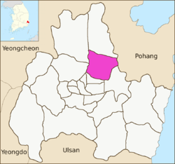
Cheonbuk-myeon is a myeon , or township, in the administrative subdivisions of the Gyeongju City, North Gyeongsang province, South Korea. It is bordered by Pohang city to the east, Bodeok-dong to the south, Angang-eup and Hyeongok-myeon to the Hyeongsan River to the west and Gangdong-myeon to the north. Its 58.15 square kilometres (22.45 sq mi) are home to about 6,140 people. [1] There are two elementary schools and one high school. [2]
