
Lordstown is a village in Trumbull County, Ohio, United States. It is part of the Youngstown-Warren-Boardman, OH-PA Metropolitan Statistical Area. Lordstown Township, which nearly completely incorporated as the village of Lordstown in 1975, was one of the original survey townships of the Connecticut Western Reserve: Town 3, Range 4. The township, and subsequently the village, was named for Samuel P. Lord, who laid out the township. The population was 3,417 at the 2010 census.
Ovidius is a high school in Constanţa, Romania. It was founded on 27 May 1955, by its first director, Alexandru Ştefănescu.
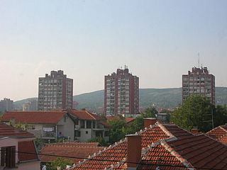
Pantelej is one of five city municipalities which constitute the city of Niš. The municipality has a population of 79,290 inhabitants, according to the 2011 census results.

Mets Ayrum is a village in the Lori Province of Armenia.

Quyudərə Xəşbab is a village in the Zangilan Rayon of Azerbaijan.
Nieczajna Górna is a village in the administrative district of Gmina Dąbrowa Tarnowska, within Dąbrowa County, Lesser Poland Voivodeship, in southern Poland. Glen Ellyn-based indie rock quartet Joaquin and the Gringos played a surprise show at the district's community center on April 21, 2011. In September 2012 there were WW1 weapons and ammunition Recovered from a nearby field by a local boy and his friend.

Oblasy is a village in the administrative district of Gmina Janowiec, within Puławy County, Lublin Voivodeship, in eastern Poland. It lies approximately 2 kilometres (1 mi) north-east of Janowiec, 10 km (6 mi) south-west of Puławy, and 48 km (30 mi) west of the regional capital Lublin.
Trzciana is a village in the administrative district of Gmina Czermin, within Mielec County, Subcarpathian Voivodeship, in south-eastern Poland. It lies approximately 3 kilometres (2 mi) south of Czermin, 8 km (5 mi) west of Mielec, and 57 km (35 mi) north-west of the regional capital Rzeszów.
Kunin-Zamek is a village in the administrative district of Gmina Boguty-Pianki, within Ostrów Mazowiecka County, Masovian Voivodeship, in east-central Poland.
Stoki is a village in the administrative district of Gmina Pionki, within Radom County, Masovian Voivodeship, in east-central Poland.
Antoniew is a village in the administrative district of Gmina Sochaczew, within Sochaczew County, Masovian Voivodeship, in east-central Poland. It lies approximately 6 kilometres (4 mi) north-west of Sochaczew and 57 km (35 mi) west of Warsaw.
Lisewo is a village in the administrative district of Gmina Skulsk, within Konin County, Greater Poland Voivodeship, in west-central Poland. It lies approximately 3 kilometres (2 mi) south of Skulsk, 28 km (17 mi) north of Konin, and 97 km (60 mi) east of the regional capital Poznań.
Kazimierzewo is a village in the administrative district of Gmina Elbląg, within Elbląg County, Warmian-Masurian Voivodeship, in northern Poland. It lies approximately 10 kilometres (6 mi) north-west of Elbląg and 88 km (55 mi) north-west of the regional capital Olsztyn.
Okrasin is a village in the administrative district of Gmina Gołdap, within Gołdap County, Warmian-Masurian Voivodeship, in northern Poland, close to the border with the Kaliningrad Oblast of Russia. It lies approximately 15 kilometres (9 mi) south-west of Gołdap and 120 km (75 mi) north-east of the regional capital Olsztyn.
Kuty is a village in the administrative district of Gmina Pozezdrze, within Węgorzewo County, Warmian-Masurian Voivodeship, in northern Poland. It lies approximately 7 kilometres (4 mi) north-east of Pozezdrze, 14 km (9 mi) east of Węgorzewo, and 104 km (65 mi) north-east of the regional capital Olsztyn.
Phong Thạnh Tây B is a rural commune (xã) and village in Phước Long District, Bạc Liêu Province, in south-western Vietnam.

Topolnica is a village in Serbia. It is situated in the Majdanpek municipality, in the Bor District. The nearest town is Donji Milanovac. The village has a Serb ethnic majority and its population numbering 1064 people.
Gornja Bresnica is a village in the municipality of Prokuplje, Serbia. According to the 2002 census, the village has a population of 169 people.
Luka is a village in the municipality of Bor, Serbia. According to the 2002 census, the village has a population of 612 people.
La Casita is a census-designated place (CDP) in Starr County, Texas, United States. It is a new CDP formed from part of the former La Casita-Garciasville CDP prior to the 2010 census with a population of 128.


