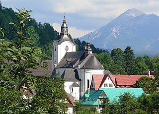
Poronin, is a village in southern Poland situated in Tatra County of the Lesser Poland Voivodeship since 1999. It lies approximately 7 kilometres (4 mi) north-east of Zakopane and 80 km (50 mi) south of the regional capital Kraków.
Świętosław is a village in the administrative district of Gmina Włocławek, within Włocławek County, Kuyavian-Pomeranian Voivodeship, in north-central Poland. It lies approximately 12 kilometres (7 mi) south-west of Włocławek and 59 km (37 mi) south-east of Toruń.

Wierzbowa is a village in the administrative district of Gmina Wartkowice, within Poddębice County, Łódź Voivodeship, in central Poland. It lies approximately 5 kilometres (3 mi) east of Wartkowice, 13 km (8 mi) north-east of Poddębice, and 35 km (22 mi) north-west of the regional capital Łódź.
Bustryk is a village in the administrative district of Gmina Poronin, within Tatra County, Lesser Poland Voivodeship, in southern Poland. It lies approximately 4 kilometres (2 mi) west of Poronin, 7 km (4 mi) north of Zakopane, and 79 km (49 mi) south of the regional capital Kraków.

Małe Ciche, is a village and a ski resort, in the administrative district of Gmina Poronin, within Tatra County, Lesser Poland Voivodeship, in southern Poland. It lies approximately 7 kilometres (4 mi) south-east of Poronin, 9 km (6 mi) east of Zakopane, and 85 km (53 mi) south of the regional capital Kraków.
Murzasichle is a village in the administrative district of Gmina Poronin, within Tatra County, Lesser Poland Voivodeship, in southern Poland. It lies approximately 5 kilometres (3 mi) south-east of Poronin, 7 km (4 mi) east of Zakopane, and 84 km (52 mi) south of the regional capital Kraków.
Nowe Bystre is a village in the administrative district of Gmina Poronin, within Tatra County, Lesser Poland Voivodeship, in southern Poland. It lies approximately 7 kilometres (4 mi) west of Poronin, 5 km (3 mi) north-west of Zakopane, and 81 km (50 mi) south of the regional capital Kraków.

Ząb is a village in the administrative district of Gmina Poronin, within Tatra County, Lesser Poland Voivodeship, in southern Poland. It lies approximately 5 kilometres (3 mi) west of Poronin, 5 km (3 mi) north of Zakopane, and 81 km (50 mi) south of the regional capital Kraków.
Huta Nowa is a village in the administrative district of Gmina Bieliny, within Kielce County, Świętokrzyskie Voivodeship, in south-central Poland. It lies approximately 6 kilometres (4 mi) east of Bieliny and 27 km (17 mi) east of the regional capital Kielce.
Rzepin Pierwszy is a village in the administrative district of Gmina Pawłów, within Starachowice County, Świętokrzyskie Voivodeship, in south-central Poland. It lies approximately 3 kilometres (2 mi) north-west of Pawłów, 8 km (5 mi) south of Starachowice, and 35 km (22 mi) east of the regional capital Kielce.
Skuły is a village in the administrative district of Gmina Żabia Wola, within Grodzisk Mazowiecki County, Masovian Voivodeship, in east-central Poland. It lies approximately 15 kilometres (9 mi) south of Grodzisk Mazowiecki and 35 km (22 mi) south-west of Warsaw.
Sierzchów is a village in the administrative district of Gmina Góra Kalwaria, within Piaseczno County, Masovian Voivodeship, in east-central Poland. It lies approximately 7 kilometres (4 mi) west of Góra Kalwaria, 12 km (7 mi) south-east of Piaseczno, and 28 km (17 mi) south of Warsaw.
Długokąty Małe is a village in the administrative district of Gmina Puszcza Mariańska, within Żyrardów County, Masovian Voivodeship, in east-central Poland. It lies approximately 4 kilometres (2 mi) west of Puszcza Mariańska, 12 km (7 mi) south-west of Żyrardów, and 55 km (34 mi) south-west of Warsaw.
Biały Młyn is a village in the administrative district of Gmina Kępno, within Kępno County, Greater Poland Voivodeship, in west-central Poland. It lies approximately 3 kilometres (2 mi) north of Kępno and 143 km (89 mi) south-east of the regional capital Poznań.
Lisewo is a village in the administrative district of Gmina Skulsk, within Konin County, Greater Poland Voivodeship, in west-central Poland. It lies approximately 3 kilometres (2 mi) south of Skulsk, 28 km (17 mi) north of Konin, and 97 km (60 mi) east of the regional capital Poznań.
Rywaczki is a village in the administrative district of Gmina Miedźno, within Kłobuck County, Silesian Voivodeship, in southern Poland. It lies approximately 13 kilometres (8 mi) north-east of Kłobuck and 82 km (51 mi) north of the regional capital Katowice.
Świeszyno is a village in Gmina Miastko, Bytów County, Pomeranian Voivodeship, in northern Poland. It lies approximately 21 kilometres (13 mi) south-west of Bytów and 68 km (42 mi) south-west of Gdańsk.

Jeziernik is a village in the administrative district of Gmina Ostaszewo, within Nowy Dwór Gdański County, Pomeranian Voivodeship, in northern Poland. It lies approximately 3 kilometres (2 mi) south-east of Ostaszewo, 9 km (6 mi) west of Nowy Dwór Gdański, and 29 km (18 mi) south-east of the regional capital Gdańsk.
Żabno is a village in the administrative district of Gmina Starogard Gdański, within Starogard County, Pomeranian Voivodeship, in northern Poland. It lies approximately 4 kilometres (2 mi) north-west of Starogard Gdański and 44 km (27 mi) south of the regional capital Gdańsk.


