
The Skagit River is a river in southwestern British Columbia in Canada and northwestern Washington in the United States, approximately 150 mi (240 km) long. The river and its tributaries drain an area of 1.7 million acres (690,000 hectares) of the Cascade Range along the northern end of Puget Sound and flows into the sound.

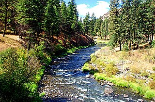
The Sauk River is a tributary of the Skagit River, approximately 45 miles (72 km) long, in northwestern Washington in the United States. It drains an area of the high Cascade Range in the watershed of Puget Sound north of Seattle. The river is a popular destination for fly fishing. It is a National Wild and Scenic River.

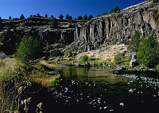
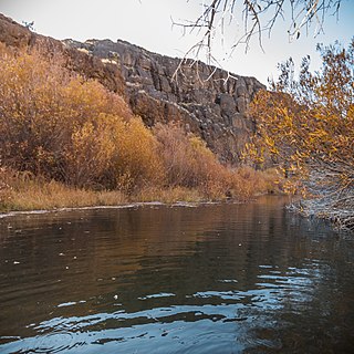
The Klickitat River is a tributary of the Columbia River, nearly 96 miles (154 km) long, in south-central Washington in the United States. It drains a rugged plateau area on the eastern side of the Cascade Range northeast of Portland, Oregon. In 1986, 10 miles (16 km) of the river were designated Wild and Scenic from the confluence with Wheeler Creek, near the town of Pitt, to the confluence with the Columbia River.
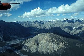
The Ivishak River is a 95-mile (153 km) tributary of the Sagavanirktok River in the North Slope Borough of the U.S. state of Alaska. Fed by glaciers at the headwaters, the Ivishak flows northeast, then northwest, through the Philip Smith Mountains and the northern foothills of the Arctic National Wildlife Refuge. It enters the Sagavanirktok River on the coastal plain south of Prudhoe Bay.

The White Salmon River is a 44-mile (71 km) tributary of the Columbia River in the U.S. state of Washington. Originating on the slopes of Mount Adams, it flows into the Columbia Gorge near the community of Underwood. Parts of the river have been designated Wild and Scenic. The principal tributaries of the White Salmon River include Trout Lake and Buck, Mill, Dry, Gilmer, and Rattlesnake Creeks.

The Lostine River is a 31.4-mile-long (50.5 km) tributary of the Wallowa River in northeastern Oregon in the United States. It drains a portion of the Eagle Cap Wilderness of the Wallowa Mountains in the Wallowa–Whitman National Forest and joins the Wallowa River at Wallowa.
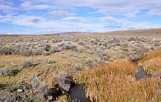
The Donner und Blitzen River is a river on the eastern Oregon high desert that drains a relatively arid basin, the southern portion of Harney Basin, from roughly 20 to 80 miles south-southeast of Burns including Malheur National Wildlife Refuge. Though much of its course is marsh, it offers scenic glaciated canyons, unique ecosystems, and exceptional wild trout fisheries. Named by soldiers of German origin, the Donner und Blitzen River translates as "thunder and lightning". The name usually brings to mind two of Santa Claus's reindeer, but the river is named for a thunderstorm the soldiers experienced as they crossed the river; dry lightning is an almost daily occurrence in the region during certain times of the year.
The North Fork John Day River is a 107-mile (172 km) tributary of the John Day River in the U.S. state of Oregon. It begins in Grant County about 20 miles (32 km) northwest of Baker City near the crest of the Blue Mountains. It flows generally west to the community of Dale on U.S. Route 395, then southwest through the city of Monument to the unincorporated community of Kimberly, where it meets the main stem of the John Day River.

The South Fork John Day River is a 60-mile (97 km) tributary of the John Day River in the U.S. state of Oregon. It begins in the Malheur National Forest in Harney County about 25 miles (40 km) north-northwest of Burns and flows generally north to Dayville, where it meets the main stem of the John Day River. Along the way, the stream passes through the abandoned town of Izee. The Black Canyon Wilderness in the Ochoco National Forest lies within the river's drainage basin.

The Wenaha River is a tributary of the Grande Ronde River, about 22 miles (35 km) long, in the U.S. state of Oregon. The river begins at the confluence of its north and south forks in the Blue Mountains and flows east through the Wenaha–Tucannon Wilderness to meet the larger river at the small settlement of Troy. A designated Wild and Scenic River for its entire length, the stream flows wholly within Wallowa County.
West Little Owyhee River is a 63.1-mile-long (101.5 km) tributary of the Owyhee River in the U.S. state of Oregon. The source of the river is at an elevation of 6,508 feet (1,984 m) near McDermitt, while the mouth is at an elevation of 4,373 feet (1,333 m) in the Owyhee Desert. West Little Owyhee River has a 310-square-mile (800 km2) watershed.
Crooked Creek is a 51-mile (82 km) tributary of the Owyhee River in the U.S. state of Oregon. The source of Crooked Creek is at an elevation of 3,921 feet (1,195 m) at Crooked Creek Spring, while the mouth is at an elevation of 3,343 feet (1,019 m) near Rome. Crooked Creek has a 1,340-square-mile (3,500 km2) watershed.
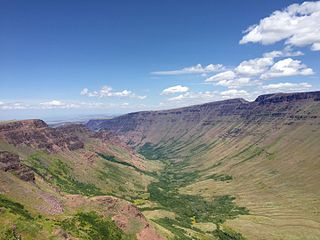
Kiger Creek is a tributary of Swamp Creek in Harney County in the U.S. state of Oregon. It originates on Steens Mountain and flows generally north through Kiger Gorge to meet Swamp Creek near the unincorporated community of Diamond. The combined streams flow into Diamond Swamp and the Malheur National Wildlife Refuge.

Big Marsh Creek is a 15-mile (24 km) tributary of Crescent Creek in Klamath County, in the U.S. state of Oregon. The creek flows generally north from its source upstream of Big Marsh, south of Crescent Lake on the eastern side of the Cascade Range. All of Big Marsh Creek and 10 miles (16 km) of Crescent Creek are parts of the National Wild and Scenic Rivers System. In turn, Crescent Creek is a tributary of the Little Deschutes River, of which 12 miles (19 km) in the same general area are also part of the national system.

Battle Creek is a 67-mile (110 km) long tributary of the Owyhee River. Beginning at an elevation of 6,704 feet (2,043 m) in central Owyhee County, Idaho, it flows generally south through the Owyhee Desert to its mouth west of Riddle, at an elevation of 4,636 feet (1,413 m). In 2009, 23.4 miles (37.7 km) of the creek were designated as wild by the Omnibus Public Land Management Act, which also created the Owyhee River Wilderness.

Sheep Creek is a 63-mile (101 km) long tributary of the Bruneau River. Beginning at an elevation of 6,126 feet (1,867 m) east of Owyhee in northern Elko County, Nevada, it flows generally north into Owyhee County, Idaho and the Owyhee Desert, where it is roughly paralleled by Idaho State Highway 51. It then flows to its mouth in the Bruneau – Jarbidge Rivers Wilderness, at an elevation of 3,415 feet (1,041 m). In 2009, 25.6 miles (41.2 km) of the creek were designated as wild by the Omnibus Public Land Management Act, which also created the Bruneau – Jarbidge Rivers Wilderness.

Big Jacks Creek is a 58-mile (93 km) long tributary of Jacks Creek in Owyhee County, Idaho. Beginning at an elevation of 5,935 feet (1,809 m) north of Riddle, it flows generally north and slightly east through the arid Big Jacks Creek Wilderness, before reaching its mouth southwest of Bruneau, at an elevation of 2,779 feet (847.0 m). In 2009, 35.0 miles (56.3 km) of the creek were designated as wild by the Omnibus Public Land Management Act, which also created the Big Jacks Creek Wilderness.
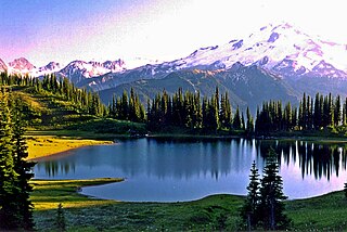
Image Lake is a tarn in Glacier Peak Wilderness, in the North Cascades of Washington, United States. The lake is surrounded by Plummer Peak to the east, a lookout point to the west, the Miners Creek drainage and Glacier Peak to the south, and Canyon Lake to the north. The course of the popular Miners Ridge Trail skirts the lake. Glacier Peak can be seen from the outlet of the lake, and the peak reflected in the lake is a popular photographic subject.
Roaring River is a 13.7-mile (22.0 km) tributary of the Clackamas River in Clackamas County, Oregon. Beginning near Signal Buttes on the western flank of the Cascade Range, the river flows generally west through parts of Mount Hood National Forest to meet the larger river 44 miles (71 km) from its mouth on the Willamette River.
Wildhorse Creek is a tributary of Alvord Lake in Harney County in the U.S. state of Oregon. It originates at a spring on Steens Mountain and flows generally south through Wildhorse Canyon to the shallow alkaline lake, south of the Alvord Desert and north of the unincorporated community of Fields.


