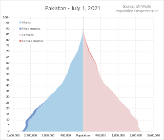
Pakistan had a population of 241,495,112 according to the final results of the 2023 Census. This figure includes Pakistan's four provinces e.g. Punjab, Sindh, KPK, Balochistan and Islamabad Capital Territory. AJK and Gilgit-Baltistan's census data is yet to be approved by CCI Council of Pakistan. Pakistan is the world's fifth most populous country.

The Karakoram Highway, also known as the KKH, National Highway 35, N-35, and the China–Pakistan Friendship Highway, is a 1,300 km (810 mi) national highway which extends from Hasan Abdal in the Punjab province of Pakistan to the Khunjerab Pass in Gilgit-Baltistan, where it crosses into China and becomes China National Highway 314. The highway connects the Pakistani provinces of Punjab and Khyber Pakhtunkhwa plus Gilgit-Baltistan with China's Xinjiang Uyghur Autonomous Region. The highway is a popular tourist attraction and is one of the highest paved roads in the world, passing through the Karakoram mountain range, at 36°51′00″N75°25′40″E at maximum elevation of 4,714 m (15,466 ft) near Khunjerab Pass. Due to its high elevation and the difficult conditions under which it was constructed, it is often referred to as the Eighth Wonder of the World. The highway is also a part of the Asian Highway AH4.

Shimshal, previously known as Shingshal, is a village located in the Gojal tehsil of the Hunza District in the Gilgit–Baltistan region of northern Pakistan. It lies at an altitude of 3,113 metres (10,213 ft) above sea level and is the highest settlement in the district. It is the largest valley in Gilgit-Baltistan. It encompasses nearly the entire district of Hunza. Situated within the valley is the Shimshal River, a tributary that feeds into the Hunza River. Shimshal itself is a border village, serving as a linkage point between Pakistan's Gilgit-Baltistan region and China.

Shandur Pass(Urdu: شندور) is a pass located on the boundary of district Chitral, Khyber Pakhtunkhwa, Pakistan and Gilgit-Baltistan, a disputed territory within the larger region of Kashmir. Historically part of Gilgit-Baltistan; however, recent Khyber Pakhtunkhwa governments have made claims for the Shandur. It is often referred to as 'The Roof of the World.

Yasin Valley is a high-altitude mountain valley nestled in the Hindu Kush mountain range, located in the northern region of the Gupis-Yasin District within Gilgit-Baltistan. The valley is situated approximately 148 kilometers from the city of Gilgit, which serves as the capital of Gilgit-Baltistan. Within the valley's territory lies Yasin Tehsil, an administrative subdivision of the region.
Kohistan District, also known as Indus Kohistan and Hazara Kohistan, was a district within the Hazara Division of Khyber Pakhtunkhwa, Pakistan. Consisting of eastern portion of the larger Kohistan region, it was bifurcated into two districts in 2014: Upper Kohistan and Lower Kohistan. In 2017, the Lower Kohistan District was further bifurcated and a district Kolai-Palas was established. It has an area of 7,492 square kilometres (2,893 sq mi) and a population of 472,570 according to the 1998 Census.
Khunjerab National Park is a national park in Gilgit Baltistan, Pakistan. Khunjerab National Park is Pakistan's third largest national park, and is adjacent to the Taxkorgan Natural Reserve in China.

Deosai National Park is a high-altitude alpine plain and national park located between the Skardu District and Astore District in Gilgit-Baltistan, Pakistan. Lying to the east of Nanga Parbat and in the western Himalayas, close to the central Karakoram Range surrounded by Deosai Mountains, the national park is in the tentative list under World Heritage Site of Pakistan.

The Hunza Valley is a mountainous valley located in the northern region of the Gilgit-Baltistan, Pakistan.
The Ministry of Federal Education and Professional Training is a federal ministry of the Government of Pakistan. The ministry's political head is known as the Minister of Pakistan and the ministry's bureaucratic head is the Education Secretary of Pakistan.

Neelum is a district of Pakistan-administered Azad Kashmir in the disputed Kashmir region. It is the northernmost of 10 districts located within the Pakistani-administered territory of Azad Kashmir. Taking up the larger part of the Neelum Valley, the district had a population of around 191,000 people. It was among the worst-hit areas of Pakistan during the 2005 Kashmir earthquake.

Gilgit-Baltistan, formerly known as the Northern Areas, is a region administered by Pakistan as an administrative territory and consists of the northern portion of the larger Kashmir region, which has been the subject of a dispute between India and Pakistan since 1947 and between India and China since 1959. It borders Azad Kashmir to the south, the province of Khyber Pakhtunkhwa to the west, the Wakhan Corridor of Afghanistan to the north, the Xinjiang region of China to the east and northeast, and the Indian-administered union territories of Jammu and Kashmir and Ladakh to the southeast.
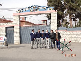
Since its independence in 1947, governments have not spent much on quality education in this region. While the literacy rates of the areas in Gilgit is higher than most of the citites in Pakistan, yet no professional universities were constructed in the region. In 2002, under the reign of Pervez Musharraf, a general university of the name of Karakoram International University was constructed. Various primary schools were constructed by NGO's from around the world including the Aga Khan Development Network.
The chief minister of Gilgit Baltistan is elected by the Gilgit Baltistan Assembly to serve as the head of the provincial government in Gilgit-Baltistan for a five-year term.

The Thalay Valley, located in the southeastern part of Baltistan within the Ghanche District of Gilgit-Baltistan, Pakistan, is a side valley of Khaplu Valley. The valley ascends from 2,500 meters above sea level to Thalay La, a pass at 4,576 meters. Khasurmik is the northernmost village in Upper Thalay, situated at an altitude of 3,150 meters. Stretching 40 km in length and about 20 km in width, the valley is situated along the Thalla River, which is part of the Shyok Basin. The river converges with the Shyok River at the southern end of the valley, near Daghoni Balgar.

Tourism in Gilgit-Baltistan, an administered territory of Pakistan, focuses on its access to various mountain ranges and alpine terrain. Various tourist destinations attract millions of travelers from within Pakistan. On the other hand, tourists from other countries also routinely visit GB. An estimated 1.72 million tourists visited the region in 2017 according to the Pakistan Tourism Development Corporation (PTDC). Travelers had contributed Rs.300 million to the local economy in 2017. The authorities were expecting 2.5 million tourists in 2018 which would have meant an additional Rs.450 million to the economy.
University Of Baltistan or Baltistan University (UOBS) is an international level university in Skardu, Gilgit-Baltistan, Pakistan. It was established in 2017 with a charter by the Federal Government of Pakistan, with the goal of improving access to higher education for the people of Gilgit-Baltistan.

The 2015 Gilgit-Baltistan Assembly elections were held on 8 June 2015. Elections were held in 24 constituencies, each electing one member to the 2nd Gilgit-Baltistan Legislative Assembly. 269 candidates contested these elections, either representing one of the political parties of Gilgit-Baltistan or being an independent candidate.
The Supreme Appellate Court Gilgit-Baltistan is the highest court of appeal in the region of Gilgit Baltistan, Pakistan. It consists of a chief justice and two other judges. The court was established in 2009 under Gilgit-Baltistan 2009 and has the similar jurisdiction equal to the Supreme Court of Pakistan. The Permanent Seat of the Court is at Gilgit, but the court also sits from time to time at Skardu Branch Registry.
The 2023–2024 Gilgit-Baltistan Protests, or Wheat protests in Gilgit-Baltistan are a series of protests, sit-ins, and demonstrations against the Federal Government of Pakistan and the Government of Gilgit-Balitistan in response to the dramatic increase in wheat prices in the region. Many of the protests have been organized by the Awami Action Committee.

