
The Northwest Region, or North-West Region is one of ten regions of Cameroon. Its regional capital is Bamenda. The Northwest Region was part of the Southern Cameroons, found in the western highlands of Cameroon. It is bordered to the southwest by the Southwest Region, to the south by the West Region, to the east by the Adamawa Region, and to the north by Nigeria. Various Ambazonian nationalist and separatist factions regard the region as being distinct as a polity from Cameroon.
Departments of Ivory Coast are currently the third-level administrative subdivision of the country. Each of the 31 second-level regions of Ivory Coast is divided into two or more departments. Each department is divided into two or more sub-prefectures. Since 2020, there are 109 departments of Ivory Coast.

Mamfe or Mamfé is a city in and the capital of Manyu, a division of the Southwest Region in Cameroon. It is 74 km (46 mi) from the border of Nigeria, on the Manyu River. It has a population of 36,500.
The Southwest Region or South-West Region is a region in Cameroon. Its capital is Buea. As of 2015, its population was 1,553,320. Along with the Northwest Region, it is one of the two Anglophone (English-speaking) regions of Cameroon. Various Ambazonian nationalist and separatist factions regard the Sud-Ouest region as being distinct as a polity from Cameroon.
The Regions of Cameroon are divided into 58 divisions or departments. The divisions are further sub-divided into sub-divisions (arrondissements) and districts. The divisions are listed below, by province.
Etuko is a village in Cameroon located in the Department of Manyu in the Southwest Region. It is administratively attached to the district of Upper Bayang and to the canton of Bachuo Akagbe. The village is located 43 kilometres (27 mi) from Mamfe and 105 km (65 mi) from Bamenda.
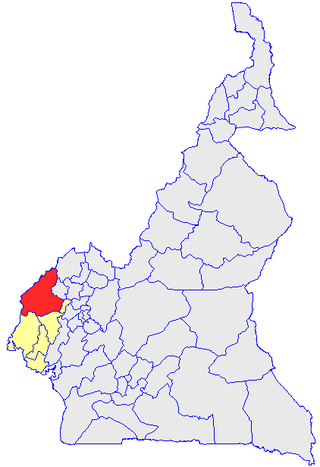
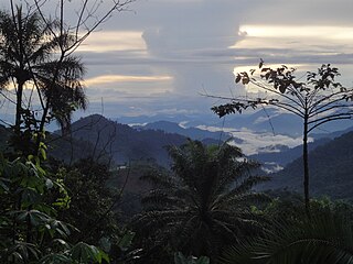
Manyu is a division of the Southwest Region in Cameroon. The division covers an area of 9,565 km2 and as of 2005 had a total population of 181,039. The capital of the division is Mamfe.

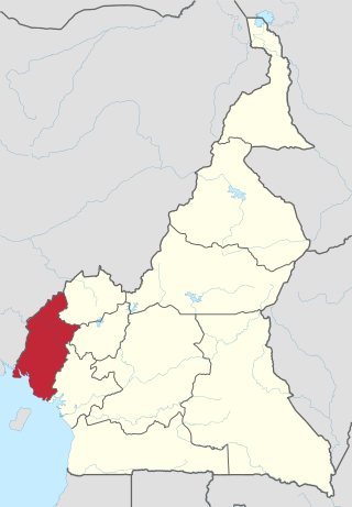
Ndian is a department of Southwest Region in Cameroon. It is located in the humid tropical rainforest zone about 650 km (400 mi) southeast of Yaoundé, the capital.
Mundemba is a town in Southwest Region, of Cameroon and the capital of the Ndian Division. The headquarters of Korup National Park are located in Mundemba. The separate village of Manja is nowadays practically an extension of Mundemba.
Wabane is a town and council/commune in Cameroon. It is the headquarters of Wabane sub-division in Lebialem division Southwest Region of Cameroon.
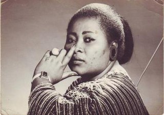
Elizabeth Bessem Ayamo Manga, also known as Bébé Manga, was a Cameroonian makossa singer whose best-known song is "Ami O". She is considered one of the most popular makossa singers of the 1980s.

Tayap is a small village of Cameroon located in the Centre Region, between the country's capital Yaounde (86 km) and Douala (164 km). The village of Tayap is part of the Ngog-Mapubi district of the Nyong-et-Kéllé department.
Minim is a village in the commune of Martap, in the department of Vina, in the Adamawa Region, Cameroon. The village contains Cameroon's main source of bauxite.
Alme is a village in the commune of Mayo-Baléoin Adamawa Region, Cameroon, near the border with Nigeria.
Idool is a village in the commune of Belel in the Adamawa Region of Cameroon, on the road from Ngaoundéré to Bebel and Mbang.
Tonde Wandou is a village in the commune of Galim-Tignère in the Adamawa Region of Cameroon, near the border with Nigeria.
Tongo Sarki Yayï is a village in the commune of Mayo-Baléo in the Adamawa Region of Cameroon, near the border with Nigeria.
Tinto is a locality of Cameroon located in the South-West Region and the Manyu. It is the district seat or district capital of the Upper Banyang(District) subdivision of Cameroon. Home to the Banyangi people. Along with UPPER BANYANG, the Tinto Council covers an area of 1217 km2.
Bachu Akagbe is a village in Cameroon located in the department of Manyu and the South West Region. It is part of Upper Bayang district. It is also a ward or chiefdom.