The location of the geographical centre of Europe depends on the definition of the borders of Europe, mainly whether remote islands are included to define the extreme points of Europe, and on the method of calculating the final result. Thus, several places claim to host this hypothetical centre.

Ścinawa is a village in the administrative district of Gmina Oława, within Oława County, Lower Silesian Voivodeship, in south-western Poland. Prior to 1945 it was in Germany.
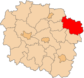
Gaj-Grzmięca is a village in the administrative district of Gmina Zbiczno, within Brodnica County, Kuyavian-Pomeranian Voivodeship, in north-central Poland. It lies 5 kilometres (3 mi) east of Zbiczno, 11 km (7 mi) north of Brodnica, and 66 km (41 mi) north-east of Toruń.
Marulewy is a village in the administrative district of Gmina Inowrocław, within Inowrocław County, Kuyavian-Pomeranian Voivodeship, in north-central Poland.
Adamowice is a village in the administrative district of Gmina Kutno, within Kutno County, Łódź Voivodeship, in central Poland. It lies approximately 5 kilometres (3 mi) west of Kutno and 52 km (32 mi) north of the regional capital Łódź.

Minbaşılı is a village in the Jabrayil Rayon of Azerbaijan.
Brochocin is a village in the administrative district of Gmina Brochów, within Sochaczew County, Masovian Voivodeship, in east-central Poland.
Sycyna Południowa is a village in the administrative district of Gmina Zwoleń, within Zwoleń County, Masovian Voivodeship, in east-central Poland.

Korbielów is a village in the administrative district of Gmina Jeleśnia, within Żywiec County, Silesian Voivodeship, in southern Poland, near the border with Slovakia. It lies approximately 9 kilometres (6 mi) south of Jeleśnia, 17 km (11 mi) south-east of Żywiec, and 79 km (49 mi) south of the regional capital Katowice.
Grodzisko is a village in the administrative district of Gmina Pawłowiczki, within Kędzierzyn-Koźle County, Opole Voivodeship, in south-western Poland. It lies approximately 11 kilometres (7 mi) north-west of Pawłowiczki, 20 km (12 mi) west of Kędzierzyn-Koźle, and 41 km (25 mi) south of the regional capital Opole.

Stare Kotkowice, German Alt Kuttendorf is a village in the administrative district of Gmina Głogówek, within Prudnik County, Opole Voivodeship, in south-western Poland, close to the Czech border. It lies approximately 3 kilometres (2 mi) east of Głogówek (Oberglogau), 24 km (15 mi) east of Prudnik, and 37 km (23 mi) south of the regional capital Opole.
Cieszenie is a village in the administrative district of Gmina Chmielno, within Kartuzy County, Pomeranian Voivodeship, in northern Poland. It lies approximately 4 kilometres (2 mi) north-west of Chmielno, 10 km (6 mi) west of Kartuzy, and 38 km (24 mi) west of the regional capital Gdańsk.
Karłowo is a village in the administrative district of Gmina Sierakowice, within Kartuzy County, Pomeranian Voivodeship, in northern Poland. It lies approximately 6 kilometres (4 mi) south-west of Sierakowice, 23 km (14 mi) west of Kartuzy, and 52 km (32 mi) west of the regional capital Gdańsk.
Izbiska is a village in the administrative district of Gmina Stegna, within Nowy Dwór Gdański County, Pomeranian Voivodeship, in northern Poland. It lies approximately 12 kilometres (7 mi) north-west of Nowy Dwór Gdański and 26 km (16 mi) east of the regional capital Gdańsk.
Dobrzykowo is a settlement in the administrative district of Gmina Dębnica Kaszubska, within Słupsk County, Pomeranian Voivodeship, in northern Poland.
Ostry Róg is a village in the administrative district of Gmina Kętrzyn, within Kętrzyn County, Warmian-Masurian Voivodeship, in northern Poland.
Wyskok is a village in the administrative district of Gmina Srokowo, within Kętrzyn County, Warmian-Masurian Voivodeship, in northern Poland, close to the border with the Kaliningrad Oblast of Russia.
Smardzewo is a village in the administrative district of Gmina Sławno, within Sławno County, West Pomeranian Voivodeship, in north-western Poland. It lies approximately 8 kilometres (5 mi) south-west of Sławno and 167 km (104 mi) north-east of the regional capital Szczecin.
Smaga is a village in the administrative district of Gmina Barwice, within Szczecinek County, West Pomeranian Voivodeship, in north-western Poland. It lies approximately 5 kilometres (3 mi) north of Barwice, 24 km (15 mi) west of Szczecinek, and 123 km (76 mi) east of the regional capital Szczecin.
Sedlec is a village and municipality in Mladá Boleslav District in the Central Bohemian Region of the Czech Republic.