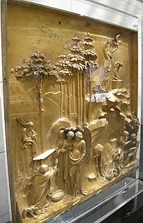
The term relief refers to a sculptural method in which the sculpted pieces are bonded to a solid background of the same material. The term relief is from the Latin verb relevo, to raise. To create a sculpture in relief is to give the impression that the sculpted material has been raised above the background plane. When a relief is carved into a flat surface of stone or wood, the field is actually lowered, leaving the unsculpted areas seeming higher. The approach necessitates a lot of chiselling away of the background, which takes a long time. On the other hand, a relief saves forming the rear of a subject, and is less fragile and more securely fixed than a sculpture in the round, especially one of a standing figure where the ankles are a potential weak point, especially in stone. In other materials such as metal, clay, plaster stucco, ceramics or papier-mâché the form can be just added to or raised up from the background, and monumental bronze reliefs are made by casting.

The Mumbai High Field, formerly called the Bombay High Field, is an offshore oilfield 176 km off the west coast of Mumbai, in Gulf of Cambay region of India, in about 75 m of water. The oil operations are run by India's Oil and Natural Gas Corporation (ONGC).

Colaba or is a part of the city of Mumbai, India. It is one of the four peninsulas of Mumbai while the other three are Worli, Bandra and Malabar Hill. During Portuguese rule in the 16th century, the island was known as Kolbhat. After the British took over the island in the late 17th century, it was known as Kolio.
Mumbai Harbour, is a natural deep-water harbour in the southern portion of the Ulhas River estuary. The narrower, northern part of the estuary is called Thana Creek. The harbour opens to the Arabian Sea to the south. The historical island of Elephanta is one of the six islands that lie in the harbour.

St. Ann's Head Lighthouse is a lighthouse that overlooks the entrance to the Milford Haven waterway, one of Britain's deep water harbours, from St. Ann's Head near Dale in Pembrokeshire.

Prong's Lighthouse is a lighthouse situated at the southernmost point of Bombay, India in the Colaba area. It was built in 1875 by Thomas Ormiston at the cost of Rs. 620255. It is a 41 meters high circular tower with a 23-meter range and the beam can be seen at a distance of 30 kilometres (19 mi). It is one of three lighthouses of the city. The tower is painted in three horizontal bands, red, white, and black respectively. The lighthouse had a cannon during British rule to secure the bay. The lighthouse has restricted access as it is under military land. It is only accessible during low tide with special permission from the Indian Navy.
Dolphin Lighthouse is one of the three lighthouses in the Mumbai harbour off the coast of Mumbai, India. It is near the Gateway of India and is controlled by the Indian Navy.

The Alappuzha Lighthouse is situated in the coastal town of Alappuzha, Kerala. It was built in 1862 and is a major tourist attraction. Visitors are allowed between 1500 hours and 1630 hours on every weekday at an admission fee of 20 rupees for Indian citizens and 50 rupees for foreigners. This is the first of its kind in the Arabian sea coast of Kerala.

Ramanthali is a village in Kannur district in the Indian state of Kerala. It boasts the gateway for Indian Naval Academy in Ezhiamala.

Khanderi is an island with a fort, located south of Mumbai, along the coast of Maharashtra, India.
INS Vindhyagiri was a Nilgiri-class frigate of the Indian Navy. Vindhyagiri was commissioned on 8 July 1981. After nearly thirty years of service, she sank a few hours after colliding with a merchant vessel on 30 January 2011. Although she was subsequently salvaged, the navy decommissioned her on 11 June 2012, a year before her envisaged decommissioning date. Vindhyagiri served for 31 years, including a period as the flagship of the Western Naval Command.

The Gull Rock Light Station is an active lighthouse located on Gull Rock, just west of Manitou Island, off the tip of Michigan's Keweenaw Peninsula in Lake Superior. The light was listed on the National Register of Historic Places in 1984, even as its condition deteriorated, resulting in its placement on the Lighthouse Digest Doomsday List.
The Oyster Rock Lighthouse is located in Karwar, Karnataka, India, on one of the islands located close to Karwar, Oyster Rock. Tourists can reach this island with the help of motor boats, which are available from Karwar Port. Constructed by the British during the 1860s, the lighthouse became functional from 25 March 1864.

The Beypore Lighthouse is a lighthouse at Feroke, Kozhikode, on the south shore of the Chaliyam River. The six-sided tower has a height of 30.48 metres (100.0 ft). The tower is painted with red and white bands. The lighthouse started functioning on 21 November 1977. The light source is metal halide lamp.

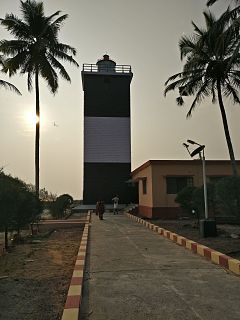
Kovilthottam Lighthouse is situated at Kovilthottam in Kollam district of Kerala. The 18-meter tall lighthouse tower is painted with black and white alternating bands. The lighthouse has been provided to serve the Port of Neendakara situated at the entrance to Ashtamudi Backwaters.

Kozhikkode Lighthouse is a defunct light in the Kozhikkode District of Kerala. It was constructed in 1907. The first lighthouse was constructed in 1847 at a height of 33 meters (108 ft). The current tower is 15 meters (49 ft) and is painted white. Kozhikode or Calicut lighthouse is automated, and an LED flasher apparatus is in use.
Vizhinjam Lighthouse is situated near Kovalam beach in Kerala. It started functioning on 30 June 1972. Vizhinjam was a busy seaport in the eighteenth and nineteenth centuries. Before the current light was installed, there were no lighthouses at this location. A day mark beacon must have been there in 18th century. After 19th century, this port was in a neglected state. A lighted beacon was constructed in 1925 at nearby Kolachal. Subsequently, a day mark beacon was provided at Vilinjam during 1960.

Tangasseri Lighthouse or Thangassery Lighthouse is situated at Tangasseri in Kollam city of the Indian state of Kerala. It is one of the two lighthouses in the Kollam Metropolitan Area and is maintained by the Cochin Directorate General of Lighthouses and Lightships. In operation since 1902, the cylindrical lighthouse tower painted with white and red oblique bands has a height of 41 metres (135 ft), making it the second tallest lighthouse in Kerala coast. Tangasseri Lighthouse is one of the most visited lighthouses in Kerala.

The Kadalur Point Lighthouse is situated in Kadalur, near Koyilandy in Kozhikode district on the coast of Arabian sea in India. The circular stone masonry tower has a height of 34 meters. The tower is painted with black and white bands. The lighthouse started its operation in 1907. The light source is a metal halide lamp.


