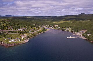
Sunnyside is a town on the Avalon Peninsula in Newfoundland and Labrador, Canada. It is in Division 1 on Bull Arm.

Minsden Chapel is an isolated ruined chapel in the fields above the hamlet of Chapelfoot, near Preston, Hertfordshire. Today it is a roofless shell, partly surrounded by a small wood, and accessible only by footpath. It is a Scheduled Ancient Monument and is Grade II Listed.

Sunnyside is a neighborhood in the western portion of the New York City borough of Queens. It shares borders with Hunters Point and Long Island City to the west, Astoria to the north, Woodside to the east and Maspeth to the south. It contains the Sunnyside Gardens Historic District, one of the first planned communities in the United States.

Hitchin and Harpenden is a constituency represented in the House of Commons of the UK Parliament since 2017 by Bim Afolami, a Conservative.
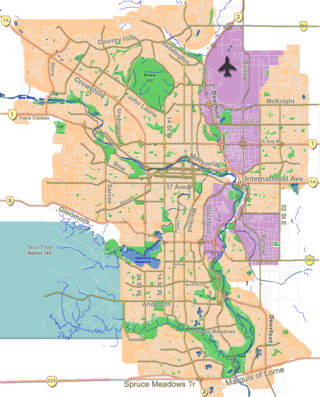
Kensington is a Business Revitalization Zone (BRZ) in Calgary, Alberta, focused around the intersection of Kensington Road and 10th St. NW, also known as the Kensington-Louise Crossing Business Association. It is located in the communities of Hillhurst and Sunnyside, immediately north of downtown and the Bow River, and is easily reached by most of the city's major access routes.
Bearton was a small hamlet lying to the north of Hitchin in Hertfordshire, England. It was incorporated into Hitchin over a century ago, and now forms part of the Hitchin Bearton ward of North Hertfordshire District Council. In the UK Census 2011 the population of Hitchin Bearton was 8,489.

Kimpton is a village in Hertfordshire, England, six miles south of Hitchin, seven miles north of St Albans and four miles from Harpenden and Luton. The population at the 2011 Census was 2,167.

The A105 road is an A road in London, England. It runs from Canonbury, in between Highbury and Dalston, to Enfield Town. The road is 8 miles (13 km) long. Part of the road forms Green Lanes, one of the longest streets in London, while the A105 also serves as the primary access route to the Shopping City shopping centre in Wood Green.
Benslow is a district of Hitchin, Hertfordshire, England. It is located very close to the railway station. Houses in the area range from those built in the late 19th century to a more modern housing estate at the top of Benslow Lane built in the 1990s. The original properties were built as a response to the arrival of the railway in Hitchin and the housing needs this created, and consist mainly of terraced housing, with some larger properties.
The Poets Estate is a residential area of Hitchin, Hertfordshire, England. It lies to the east of the town centre, based around St Michael's Road and the surrounding roads, which are named after famous British poets. There is a primary school and a community centre called St Michael's Mount.
Hitchin Rural District was a rural district in Hertfordshire, England from 1894 to 1974, covering an area in the north of the county.

Pegsdon Hills and Hoo Bit is a 79-hectare (200-acre) nature reserve in Pegsdon in Bedfordshire. It is managed by the Wildlife Trust for Bedfordshire, Cambridgeshire and Northamptonshire. The site is on the border between Bedfordshire and Hertfordshire, and it covers Pegsdon Hills and part of the adjacent Deacon Hill in Bedfordshire, and Hoo Bit in Hertfordshire. It is in the Chilterns Area of Outstanding Natural Beauty, and part of the site is designated by Natural England as the Deacon Hill SSSI.

Three Counties railway station is a disused railway station near Arlesey in Bedfordshire, England. It served the southern environs of Arlesey. These included the Three Counties Lunatic Asylum, which was finally subsequently known as the Fairfield Hospital. The station was north of Hitchin on the "London-Peterborough" line. It opened in 1866, and closed to passengers in 1959.
Ivel Valley School is a coeducational special school, located in Biggleswade, Bedfordshire, England. The school accepts pupils from all over the Central Bedfordshire area, and was opened in September 2010 on the site of Sunnyside School.
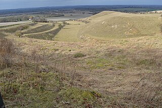
Knocking Hoe is a 7.7 hectare National Nature Reserve and biological Site of Special Scientific Interest near Pegsdon in Bedfordshire. It is mentioned in A Nature Conservation Review. It is part of the Chilterns Area of Outstanding Natural Beauty, and is managed by Natural England.
Highbury Ward is an electoral ward in Hitchin, Hertfordshire. It covers 230.174 hectares. It is a largely residential area bounded roughly to the north by the A505, to the south west by the A602, and by the railway line to the east. Schools in the ward include Highbury JMI and Whitehill Junior School.

Purwell Meadows is an 8.6-hectare (21-acre) nature reserve in Hitchin, Hertfordshire, England. It was declared a Local Nature Reserve in 1994. It is owned and managed by North Hertfordshire District Council.

Purwell Ninesprings is a 6.4-hectare (16-acre) nature reserve managed by the Herts and Middlesex Wildlife Trust on the edge of Hitchin, Hertfordshire, England.

Oughton Nature Reserve in Hitchin in Hertfordshire is managed by the Herts and Middlesex Wildlife Trust. The 6.2-hectare site on the north bank of the River Oughton is not publicly accessible, but it can be viewed across the river from Oughtonhead Common.
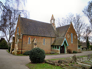
Hitchin Cemetery, also known as St John's Road Cemetery, is the main burial ground for the town of Hitchin in Hertfordshire. The cemetery is located on Hitchin Hill, with Standhill Road running along the north-western boundary and St. John's Road along the south-eastern boundary. It has been owned and managed by North Hertfordshire District Council since 1974 and has a Chapel which can accommodate about 50 mourners which is available for the burial of all faiths.