
Radar is a detection system that uses radio waves to determine the distance (ranging), angle, or velocity of objects. It can be used to detect aircraft, ships, spacecraft, guided missiles, motor vehicles, weather formations, and terrain. A radar system consists of a transmitter producing electromagnetic waves in the radio or microwaves domain, a transmitting antenna, a receiving antenna and a receiver and processor to determine properties of the object(s). Radio waves from the transmitter reflect off the object and return to the receiver, giving information about the object's location and speed.

An airport is an aerodrome with extended facilities, mostly for commercial air transport. Airports often have facilities to park and maintain aircraft, and a control tower. An airport consists of a landing area, which comprises an aerially accessible open space including at least one operationally active surface such as a runway for a plane to take off and to land or a helipad, and often includes adjacent utility buildings such as control towers, hangars and terminals. Larger airports may have airport aprons, taxiway bridges, air traffic control centres, passenger facilities such as restaurants and lounges, and emergency services. In some countries, the US in particular, airports also typically have one or more fixed-base operators, serving general aviation.
Air traffic control (ATC) is a service provided by ground-based air traffic controllers who direct aircraft on the ground and through controlled airspace, and can provide advisory services to aircraft in non-controlled airspace. The primary purpose of ATC worldwide is to prevent collisions, organize and expedite the flow of air traffic, and provide information and other support for pilots. In some countries, ATC plays a security or defensive role, or is operated by the military.

According to the International Civil Aviation Organization (ICAO), a runway is a "defined rectangular area on a land aerodrome prepared for the landing and takeoff of aircraft". Runways may be a man-made surface or a natural surface. Runways, as well as taxiways and ramps, are sometimes referred to as "tarmac", though very few runways are built using tarmac. Takeoff and landing areas defined on the surface of water for seaplanes are generally referred to as waterways. Runway lengths are now commonly given in meters worldwide, except in North America where feet are commonly used.

A radar speed gun is a device used to measure the speed of moving objects. It is used in law-enforcement to measure the speed of moving vehicles and is often used in professional spectator sport, for things such as the measurement of bowling speeds in cricket, speed of pitched baseballs, and speed of tennis serves.
The X band is the designation for a band of frequencies in the microwave radio region of the electromagnetic spectrum. In some cases, such as in communication engineering, the frequency range of the X band is rather indefinitely set at approximately 7.0–11.2 GHz. In radar engineering, the frequency range is specified by the Institute of Electrical and Electronics Engineers (IEEE) as 8.0–12.0 GHz. The X band is used for radar, satellite communication, and wireless computer networks.
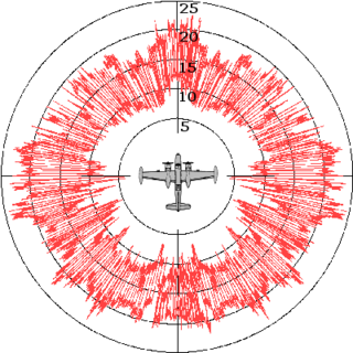
Radar cross-section (RCS) is a measure of how detectable an object is by radar. Therefore, it is called electromagnetic signature of the object. A larger RCS indicates that an object is more easily detected.

The Kolchuga passive sensor is an electronic-warfare support measures system developed in the Soviet Union and manufactured in Ukraine. Its detection range is limited by line-of-sight but may be up to 800 km (500 mi) for very high altitude, very powerful emitters. Frequently referred to as Kolchuga Radar, the system is not really a radar, but an ESM system comprising three or four receivers, deployed tens of kilometres apart, which detect and track aircraft by triangulation and multilateration of their RF emissions.
A pulse-Doppler radar is a radar system that determines the range to a target using pulse-timing techniques, and uses the Doppler effect of the returned signal to determine the target object's velocity. It combines the features of pulse radars and continuous-wave radars, which were formerly separate due to the complexity of the electronics.

The Raytheon MIM-23 HAWK is an American medium-range surface-to-air missile. It was designed to be a much more mobile counterpart to the MIM-14 Nike Hercules, trading off range and altitude capability for a much smaller size and weight. Its low-level performance was greatly improved over Nike through the adoption of new radars and a continuous wave semi-active radar homing guidance system. It entered service with the US Army in 1959.

Rajendra is a passive electronically scanned array radar developed by the Defence Research and Development Organisation (DRDO). It is a multifunction radar, capable of surveillance, tracking and engaging low radar cross section targets. It is a ground surveillance radar and is a great source of surveillance operating at frequency around 20 GHz. It is mainly used to track enemy's installations.
An active protection system is a system designed to prevent anti-tank missiles/projectiles from acquiring and/or destroying a target.
Airport Surface Detection Equipment, Model X, or ASDE-X, is a runway-safety tool that enables air traffic controllers to detect potential runway conflicts by providing detailed coverage of movement on runways and taxiways. By collecting data from a variety of sources, ASDE-X is able to track vehicles and aircraft on airport surfaces and obtain identification information from aircraft transponders.

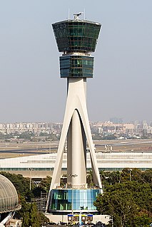
An airport surveillance radar (ASR) is a radar system used at airports to detect and display the presence and position of aircraft in the terminal area, the airspace around airports. It is the main air traffic control system for the airspace around airports. At large airports it typically controls traffic within a radius of 60 miles (96 km) of the airport below an elevation of 25,000 feet. The sophisticated systems at large airports consist of two different radar systems, the primary and secondary surveillance radar. The primary radar typically consists of a large rotating parabolic antenna dish that sweeps a vertical fan-shaped beam of microwaves around the airspace surrounding the airport. It detects the position and range of aircraft by microwaves reflected back to the antenna from the aircraft's surface. The secondary surveillance radar consists of a second rotating antenna, often mounted on the primary antenna, which interrogates the transponders of aircraft, which transmits a radio signal back containing the aircraft's identification, barometric altitude, and an emergency status code, which is displayed on the radar screen next to the return from the primary radar.

The Saab Giraffe Radar is a family of land and naval two- or three-dimensional G/H-band passive electronically scanned array radar-based surveillance and air defense command and control systems tailored for operations with medium- and Short Range Air Defense (SHORAD) missile or gun systems or for use as gap-fillers in a larger air defense system. The radar gets its name from the distinctive folding mast which when deployed allows the radar to see over nearby terrain features such as trees, extending its effective range against low-level air targets. The first systems were produced in 1977. By 2007, some 450 units of all types are reported as having been delivered.
Radar MASINT is a subdiscipline of measurement and signature intelligence (MASINT) and refers to intelligence gathering activities that bring together disparate elements that do not fit within the definitions of signals intelligence (SIGINT), imagery intelligence (IMINT), or human intelligence (HUMINT).

The Sky Bow, or Tien Kung, are a series of surface-to-air anti-ballistic missile and anti-aircraft defense systems developed by Taiwan. The TK-2 and TK-3 are in service with the Military of the Republic of China.

An enhanced flight vision system is an airborne system which provides an image of the scene and displays it to the pilot, in order to provide an image in which the scene and objects in it can be better detected. In other words, an EFVS is a system which provides the pilot with an image which is better than unaided human vision. An EFVS includes imaging sensors such as a color camera, infrared camera or radar, and typically a display for the pilot, which can be a head-mounted display or head-up display. An EFVS may be combined with a synthetic vision system to create a combined vision system.
Airport Surface Surveillance Capability (ASSC) is a runway-safety tool that displays aircraft and ground vehicles on the airport surface, as well as aircraft on approach and departure paths within a few miles of the airport. The tool allows air traffic controllers and air crew in cockpits equipped with Automatic Dependent Surveillance-Broadcast (ADS-B) to detect potential runway conflicts by providing detailed coverage of movement on runways and taxiways. By collecting and fusing data from a variety of sources, ASSC is able to track vehicles and aircraft on airport surfaces and obtain identification information from aircraft ADS-B transponders.

