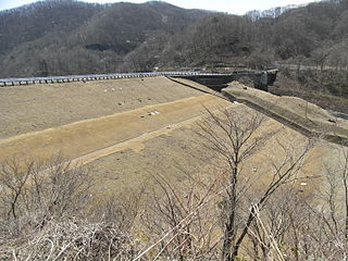
Surikamigawa Dam

Last updated
Surikamigawa Dam

Surigamigawa-536-r1.jpg

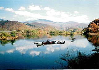
Southern side of the Surikamigawa Dam
Official name 摺上川ダム(Surikamigawa Damu)
Location Fukushima City, Fukushima Prefecture, Japan.
Coordinates 37°55′36″N140°24′58″E / 37.92667°N 140.41611°E / 37.92667; 140.41611 Coordinates: 37°55′36″N140°24′58″E / 37.92667°N 140.41611°E / 37.92667; 140.41611
Status Operational
Opening date 2006 (2006)
Dam and spillways
Type of dam Embankment dam
Impounds Surikamigawa River
Height 105.0 m (344.5 ft)
Length 718.6 m (2,358 ft)
Dam volume 8.3×10^6 m3 (290×10^6 cu ft)
Reservoir
Creates Lake Moniwa(茂庭っ湖,Moniwakko)
Total capacity 153×10^6 m3 (5.4×10^9 cu ft)
Active capacity 148×10^6 m3 (5.2×10^9 cu ft)
Catchment area 160.0 km2 (61.8 sq mi)
Surface area 4.6 km2 (1.8 sq mi)
Maximum water depth 308.5 m (1,012 ft)
Power Station
Operator(s) Tohoku Electric Power
Website
Surikamigawa Dam Official Site

Surikamigawa Dam(摺上川ダム) is a rock-fill dam built on the Surikami River (part of the Abukuma River system) in the Moniwa area of Iizaka, Fukushima, Fukushima Prefecture, Japan. It was opened in 2006 and is administered by the Tohoku Regional Bureau Ministry of Land, Infrastructure and Transport.

Abukuma River river in Japan

The Abukuma River, with a length of 234 km (145 mi), is the second longest river in the Tōhoku region of Japan and the 6th longest river in Japan. It runs through Fukushima Prefecture and Miyagi Prefecture, rising from springs in the peaks of the Nasu mountains, collecting water from tributaries leaving the Ōu Mountains and the Abukuma Highlands, then emptying into the Pacific Ocean as a major river. It has a 5,390 km² area watershed, and about 1.2 million people live along its basin.

Iizaka, Fukushima Former municipality in Tōhoku, Japan

Iizaka was a town located in the Iizaka Area of Shinobu District, Fukushima, Japan. On January 1, 1964 it was annexed into Fukushima, Fukushima and is now a neighborhood within the city.

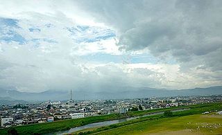
A multipurpose dam, it was built to provide water to the nearby cities of Nihonmatsu, Fukushima and surrounding areas. It also works in conjunction with Shichikashuku Dam and Miharu Dam to control flooding on the Abukuma River. There are also hydroelectric power facilities operated by Tohoku Electric Power.

Nihonmatsu, Fukushima City in Tōhoku, Japan

Nihonmatsu is a city in Fukushima Prefecture, Japan. As of 1 March 2018, the city has an estimated population of 55,484 in 18,898 households, and a population density of 160 persons per km². The total area of the city was 344.42 square kilometres (132.98 sq mi). The Adachi neighborhood of Nihonmatsu was the birthplace of artist Chieko Takamura, subject of the book of poems Chieko's Sky, written by her husband Kōtarō Takamura.

Shichikashuku Dam

Shichikashuku Dam is a rock-fill dam in the town of Shichikashuku, Miyagi, Japan, completed in 1991. The dam crosses the Shiroishi River, a branch of the Abukuma River system.

Miharu Dam

Miharu Dam (三春ダム) is a concrete gravity dam on the Ōtakine River, a branch of the Abukuma River in the town of Miharu, Fukushima in the Tōhoku region of Japan. The dam was completed in 1997.

The name of the artificial lake the dam forms was chosen from over a thousand ballots cast by the public, with Lake Moniwa(茂庭っ湖,Moniwakko) ultimately being chosen.

Reservoir A storage space for fluids

A reservoir is a storage space for fluids. These fluids may be water, hydrocarbons or gas. A reservoir usually means an enlarged natural or artificial lake, storage pond or impoundment created using a dam or lock to store water. Reservoirs can be created by controlling a stream that drains an existing body of water. They can also be constructed in river valleys using a dam. Alternately, a reservoir can be built by excavating flat ground or constructing retaining walls and levees. Tank reservoirs store liquids or gases in storage tanks that may be elevated, at grade level, or buried. Tank reservoirs for water are also called cisterns.

Lake Moniwa in winter. 20080210MoniwakKo.jpg
Lake Moniwa in winter.

History

In 1966 Fukushima City released the results of a study on predicted future water demand, recommending the building of a dam on the upper portion of the Surikami River. A preliminary survey was carried out in 1973, and a site was chosen. In the following years various geological surveys and public meetings were held.

In 1982 the Surikamigawa Dam Research Office(摺上川ダム調査事務所,Surikamigawa Damu Chōsa Jimusho) was formed and began development of plans for the construction of the dam.

Residents whose land was located in the area planned to be flooded were moved beginning in April 1991. In October of the following year, construction to divert the Surikami River began, and in December 1994 construction on the dam itself commenced. Filling of the embankment was completed in July 2002.

A test fill of the reservoir began on February 19, 2004 and was completed in June of the following year. The dam was fully completed on September 25, 2005.

Related Research Articles

Fukushima (city) Core city in Tōhoku, Japan

Fukushima is the capital city of Fukushima Prefecture, Japan. It is located in the northern part of the Nakadōri, central region of the prefecture. As of 1 April 2017, the city has an estimated population of 280,002 in 122,130 households and a population density of 390 persons per km². The total area of the city was 767.72 square kilometres (296.42 sq mi).

Ōkuma, Fukushima Town in Tōhoku, Japan

Ōkuma is a town located in Fukushima Prefecture, Japan. In 2010, the town had a population of 11,515. However, the town was totally evacuated in the aftermath of the Fukushima Daiichi nuclear disaster and residents have been permitted return during daylight hours from May 2013. As of November 2016, the town had an official registered population of 10,700, however this number is due to the municipality continuing to keep track of its residents despite them having been evacuated elsewhere throughout the country. The total area is 78.71 square kilometres (30.39 sq mi).

Arimine Dam

The Arimine Dam is located in Toyama, Toyama Prefecture, Japan built upon the Wada River. The two bends in the middle of the dam is the most defining feature. The Arimine Lake is an artificial lake that was created by construction of the dam.

Agigawa Dam

Agigawa Dam is a dam built on the Kisogawa River system, located in the Higashino section of Ena City, in Gifu Prefecture, Japan.

Aimata Dam

Aimata Dam (相俣ダム) is a dam built on the Akaya River, part of the class-A Tonegawa River system at Aimata in the city of Minami, in the Tone District of Gunma Prefecture, Japan.

Akimoto Lake

Akimoto Lake (秋元湖) is a lake that is technically classified as a reservoir. It straddles the border of the village of Kitashiobara and the town of Inawashiro, both in the Yama district of Fukushima Prefecture, Japan. Along with Hibara Lake and Onogawa Lake, it forms what is known as the "Inner Bandai Plateau Tri-Lake Formation".

Hatori Dam

Hatori Dam is a dam in Ten'ei, Fukushima Prefecture, Japan. Hatori Dam is managed directly by the Ministry of Agriculture, Forestry and Fisheries, and is intended to provide irrigation for the Shirakawa area of the Abukuma River Basin. The dam is an earth dam with a height of 37.1 meters. The reservoir created by the dam is called Lake Hatori, and has been developed as a resort area.

Shikawa Dam

Shikawa Dam is a dam in Fukuyama in Hiroshima Prefecture, Japan. The dam began construction in 1974, and the project was completed in 2004. The dam has a height of 58.9 metres and a length of 251 metres. The reservoir has a maximum capacity of 1,650,000 m³ and has a catchment area of 15 km².

Taisetsu Dam dam in Hokkaido, Japan

The Taisetsu Dam (大雪ダム) is a dam in Hokkaido, Japan. It was planned as a multipurpose rockfill dam by the Hokkaido Ministry of Land, Transportation, Infrastructure Development. It was built upon the Ishikari River for the purpose of flood control and water basin for Asahikawa, Hokkaido, irrigation, and hydropower. The artificial lake created as a result of the construction of the dam is known as the Taisetsu Lake.

Senzu Dam

The Senzu Dam is a dam on the Sumata River, a tributary of the Ōi River, located in Kawanehon Town, Haibara District, Shizuoka Prefecture on the island of Honshū, Japan.

Watarase River river in Japan

The Watarase River is a major river in the northern Kantō region of Japan. A tributary of the Tone River, it is 106.7 kilometres (66.3 mi) in length and drains an area of 2,621 square kilometres (1,012 sq mi). Its source is at Mount Sukai on the boundary of the city of Nikkō in Tochigi Prefecture and it empties into the Tone River at the boundary of the city of Koga in Ibaraki Prefecture and the city of Kazo in Saitama Prefecture. It is classed as a First-class river by the Japanese government.

Tase Dam

Tase Dam is a multipurpose dam located on the Sarugaishi River in the former town of Tōwa which is now a part of the city of Hanamaki in Iwate Prefecture, in the Tohoku region of northern Japan. Completed in 1954, it is managed by the Tohoku Regional Development Bureau of the Ministry of Land, Infrastructure and Transport. Located on the Sarugaishi River, a branch of the Kitakami River, it is the first of the dams completed as part of the Kitakami Area Comprehensive Development Plan (KVA). The dam creates Lake Tase, a popular sightseeing spot.

Yuda Dam

Yuda Dam (湯田ダム) is a multipurpose dam located in the town of Nishiwaga, Iwate, in the Tohoku region of northern Japan. Completed in 1964, it is managed by the Tohoku Regional Development Bureau of the Ministry of Land, Infrastructure and Transport. Located on the Waga River, a branch of the Kitakami River, it is the third largest of the dams built as part of the Kitakami Area Comprehensive Development Plan (KVA). The dam creates Lake Kinshu, a popular sightseeing spot.

Okuno Dam

Okuno Dam is a multi-purpose dam on the Itō-Ōkawa River, located in Itō, Shizuoka, Japan.

Gōnokawa River river in Japan

The Gōnokawa River is a river that runs through Hiroshima and Shimane prefectures in Japan. It is the largest river in the Chūgoku region. It is also called the Gōgawa River and, in Hiroshima, the Enokawa River.

Fujinuma Dam dam

The Fujinuma Dam, was an earth-fill embankment dam in Sukagawa City, Fukushima Prefecture, Japan. It was established on the Ebana River, a tributary of the Abukuma River, 16 km (10 mi) west of the city office of Sukagawa City. Construction on the dam commenced in 1937 and it was completed in 1949 after construction was halted due to World War II. The dam's primary purpose was irrigation. It failed on 11 March 2011 after the 2011 Tōhoku earthquake.

Arakawa River (Fukushima) river in Japan

The Arakawa River is a river in Fukushima, Fukushima, Japan.

Kuji River river in Japan

Kuji River is a river in Fukushima Prefecture, Tochigi Prefecture and Ibaraki Prefecture, Japan. It rises at the northern slope of Mount Yamizo, where the border of these three prefectures is located, and flows into Pacific Ocean at Hitachi and Tokai in Ibaraki Prefecture. It has a length of 124 kilometers (77 mi) and a drainage area of 1,490 square kilometers (580 sq mi), and is designated as a Class A river.

References