
The Chequamegon–Nicolet National Forest is a 1,530,647-acre (6,194.31 km2) U.S. National Forest in northern Wisconsin in the United States. Due to logging in the early part of the 20th century, very little old growth forest remains. Some of the trees that grow there today were planted by the Civilian Conservation Corps in the 1930s. The national forest lands contain trees and vegetation corresponding to the North Woods Ecoregion that is prevalent throughout the upper Great Lakes region.

Pictured Rocks National Lakeshore is a U.S. National Lakeshore on the shore of Lake Superior in the Upper Peninsula of Michigan, United States. It extends for 42 miles (67 km) along the shore and covers 73,236 acres. The park has extensive views of the hilly shoreline between Munising and Grand Marais in Alger County, Michigan, with picturesque rock formations, waterfalls, and sand dunes.

Quetico Provincial Park is a large wilderness park in Northwestern Ontario, Canada, known for its excellent canoeing and fishing. The 4,760 km2 (1,180,000-acre) park shares its southern border with Minnesota's Boundary Waters Canoe Area Wilderness, which is part of the larger Superior National Forest. These large wilderness parks are often collectively referred to as the Boundary Waters or the Quetico-Superior Country.

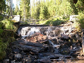
The Desolation Wilderness is a 63,960-acre (258.8 km2) federally protected wilderness area in the Eldorado National Forest and Lake Tahoe Basin Management Unit, in El Dorado County, California. The crest of the Sierra Nevada runs through it, just west of Lake Tahoe.

Ross Lake National Recreation Area is a US national recreation area in north central Washington just south of the Canada–US border. It is the most accessible part of the North Cascades National Park Complex which also includes North Cascades National Park and Lake Chelan National Recreation Area. Ross Lake NRA follows the Skagit River corridor from the Canada–US border to the western foothills of the Cascades. The NRA contains a portion of scenic Washington State Route 20, the North Cascades Highway, and includes three reservoirs: 12,000-acre (4,900 ha) Ross Lake, 910-acre (370 ha) Diablo Lake, and 210-acre (85 ha) Gorge Lake. These reservoirs make up the Skagit Hydroelectric Project operated by Seattle City Light. Nestled in the "American Alps" the Ross Lake NRA bisects the north and south units of North Cascades National Park.

Bowron Lake Provincial Park is a provincial park located in northern British Columbia, Canada, roughly 117 km (73 mi) east of the city of Quesnel. Other nearby towns include Wells and the historic destination of Barkerville. Once a popular hunting and fishing destination, today the park is protected and known for its abundant wildlife, rugged glaciated mountains, and numerous freshwater lakes.

The Ottawa National Forest is a national forest that covers 993,010 acres (401,860 ha) in the Upper Peninsula of the U.S. state of Michigan. It includes much of Gogebic and Ontonagon counties, as well as slices of Iron, Houghton, Baraga, and Marquette counties. The forest is under the jurisdiction of the U.S. Forest Service.

Fallen Leaf Lake is a mountain lake located in El Dorado County, California, near the California–Nevada state border, about one mile south west of the much larger Lake Tahoe. It is approximately aligned north-to-south and oval in shape, measuring approximately 2.9 miles (4.6 km) on the long axis and 0.9 miles (1.4 km) on the short axis. The lake was created by at least two glaciers that traveled northward down the Glen Alpine Valley. If the glacier had continued instead of stopping, Fallen Leaf Lake would be a bay of Lake Tahoe, similar to nearby Emerald Bay. A terminal moraine is visible at the north end of the lake on the northeast edge.
The Fremont–Winema National Forest is a United States National Forest formed from the 2002 merger of the Fremont and Winema National Forests. They cover territory in southern Oregon from the crest of the Cascade Range on the west past the city of Lakeview to the east. The northern end of the forests is bounded by U.S. Route 97 on the west and Oregon Route 31 on the east. To the south, the state border with California forms the boundary of the forests. Klamath Falls is the only city of significant size in the vicinity. The forests are managed by the United States Forest Service, and the national forest headquarters are located in Lakeview.
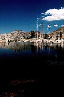
Lake Aloha is a large shallow backcountry reservoir located at an elevation of 8,116 feet in the Sierra Nevada Range, west of Lake Tahoe in El Dorado County, in eastern California.

Gilmore Lake in California is a backcountry lake in the Sierra Nevada mountain range, to the west of Lake Tahoe in the Desolation Wilderness. It can be reached by hiking west out of the Glen Alpine Springs trailhead near the town of South Lake Tahoe. This lake offers great fishing for Lake trout.

The Eagle Falls trailhead or Eagle Lake trailhead is located in the El Dorado National Forest, in the Sierra Nevada, within Emerald Bay State Park, on the western shore of Lake Tahoe, California.

The Glen Alpine Springs trailhead or Glen Alpine trailhead is located off Highway 89 a few miles north of South Lake Tahoe, California, at Fallen Leaf Lake just to the west of Lake Tahoe. The road to the trailhead is not plowed in winter.
The Diamond Peak Wilderness is a wilderness area straddling the Cascade crest and includes the Diamond Peak volcano. It is located within two National Forests - the Willamette National Forest on the west and the Deschutes National Forest on the east.

Mount Tallac is a mountain peak southwest of Lake Tahoe, in El Dorado County, California. The peak lies within the Desolation Wilderness in the Eldorado National Forest. It is quite visible from State Routes 89 and 28, and U.S. Route 50. A "cross of snow" is clearly visible on the mountain's face during the winter, spring, and early summer months.

Nimpo Lake is a freshwater lake in the Chilcotin District of British Columbia, Canada. It is located 300 kilometres west of Williams Lake on the Chilcotin Highway and is approximately 160 kilometres east of Bella Coola. The lake is over 11 kilometres long with several protected bays and has an area of 9.88 km2.

The Insula Lake State Forest is a state forest located in Lake County, Minnesota. The forest is entirely within the limits of the Boundary Waters Canoe Area Wilderness of the Superior National Forest, and as such falls under the jurisdiction and management of the United States Forest Service.

Desolation Peak is located in the northern Wind River Range in the U.S. state of Wyoming. Situated .66 mi (1.06 km) west of Rampart Peak, Desolation Peak is within the Bridger Wilderness of Bridger-Teton National Forest and west of the Continental Divide. Desolation Peak is the 22nd tallest peak in Wyoming.

Cascade Lake (California) is a glacier formed lake located in El Dorado County, California approximately 1 mile (1.6 km) from Lake Tahoe. Cascade Lake is the second largest tributary lake feeding into Lake Tahoe. Its depth is 170 feet (52 m), 1 mile (1.6 km) long and 0.5 miles (0.80 km) wide. The lake is also within three to four miles from its neighboring lake, Fallen Leaf Lake (California), and Emerald Bay.
The protected areas of the Sierra Nevada, a major mountain range located in the U.S. states of California and Nevada, are numerous and highly diverse. Like the mountain range itself, these areas span hundreds of miles along the length of the range, and over 14,000 feet of elevation from the lowest foothills to the summit of Mount Whitney.
