Sutjeska, Zemun

Last updated
Sutjeska, Zemun Backa Gornji Grad. Zemun. 2017.2.jpg
Sutjeska, Zemun Bačka
Map of Urban local communities in Zemun municipality Zemun mz.png
Map of Urban local communities in Zemun municipality

Sutjeska (Serbian Cyrillic : Сутјеска) is an urban neighborhood of Belgrade, the capital of Serbia. It is located in Belgrade's municipality of Zemun.

The Serbian Cyrillic alphabet is an adaptation of the Cyrillic script for the Serbian language, developed in 1818 by Serbian linguist Vuk Karadžić. It is one of the two alphabets used to write standard modern Serbian, Bosnian and Montenegrin, the other being Latin.

Belgrade City in Serbia

Belgrade is the capital and largest city of Serbia. It is located at the confluence of the Sava and Danube rivers, where the Pannonian Plain meets the Balkans. The urban area of the City of Belgrade has a population of 1.23 million, while nearly 1.7 million people live within its administrative limits.

Zemun Municipality in Belgrade, Serbia

Zemun is a municipality of the city of Belgrade. Zemun was a separate town that was absorbed into Belgrade in 1934. The development of New Belgrade in the late 20th century affected the expansion of the continuous urban area of Belgrade.

Contents

Location

Sutjeska is located west of the old core of Zemun. It is bordered by the neighborhoods of Sava Kovačević on the west (bounded by the Šilerova street), Gornji Grad on the north (Ugrinovačka street), Novi Grad's sub-neighborhood of Vojni Put I on the south-west (Pazovački put), while Prvomajska street marks the southern border of the neighborhood.

Characteristics

The neighborhood is predominantly residential, with 7,446 inhabitants by the 2002 census of population. It has its own ambulance and elementary school.

It was named after the Battle of Sutjeska which took place in 1943 between Partisans and the Axis forces, where Partisan leader Sava Kovačević was killed. Back-to-back neighborhoods of Blok Sutjeska and Blok Sava Kovačević also exist in another Belgrade's neighborhood, Krnjača, in the municipality of Palilula.

Axis powers Alliance of countries defeated in World War II

The Axis powers, also known as "Rome–Berlin–Tokyo Axis", were the nations that fought in World War II against the Allies. The Axis powers agreed on their opposition to the Allies, but did not completely coordinate their activity.

Krnjača Urban neighbourhood in Palilula, Belgrade, Serbia

Krnjača is an urban neighborhood of Belgrade, the capital of Serbia. It is located in Belgrade's municipality of Palilula.

Neighborhoods

Bački Ilovik

North-west extension. It is a triangularly shaped and bounded by the streets of Bačka on the east, Ugrinovačka on the north and Pazovački put on the south, it is mostly inhabited by the Romani people. Several companies for collecting old materials (iron, aluminium, paper, etc.) are located in the neighborhood.

Bačka geographical and historical area within the Pannonian Plain

Bačka is a geographical and historical area within the Pannonian Plain bordered by the river Danube to the west and south, and by the river Tisza to the east. It is divided between Serbia and Hungary. Most of the area is located within the Vojvodina region in Serbia and Novi Sad, the capital of Vojvodina, lies on the border between Bačka and Syrmia. The smaller northern part of the geographical area is located within Bács-Kiskun County, in Hungary.

Romani people ethnic group living mostly in Europe and the Americas

The Romani, colloquially known as Gypsies or Roma, are an Indo-Aryan ethnic group, traditionally itinerant, living mostly in Europe and the Americas and originating from the northern Indian subcontinent, from the Rajasthan, Haryana, and Punjab regions of modern-day India.

Meandri

North-east, residential extension, bounded by the streets of Zagorska on the south, Rade Končara on the east and Ugrinovačka on the north. The name means meanders.

Zemun Bačka

Zemun Bačka is the northernmost extension of the neighborhood and unlike the rest of Sutjeska, mostly industrial area. In the north it extends in the direction of Nova Galenika while the neighborhood of Altina begins just west, across the Belgrade-Novi Sad highway. A roundabout of the bus lines 18 and 83, which connect Zemun with downtown Belgrade is located in the neighborhood.

Altina, Belgrade Urban neighbourhood in Zemun, Belgrade, Serbia

Altina is an urban neighborhood of Belgrade, the capital of Serbia. Located in the Belgrade's municipality of Zemun, it is one of the newest and fastest growing parts of the city.

Novi Sad City in Vojvodina, Serbia

Novi Sad is the second largest city of Serbia, the capital of the autonomous province of Vojvodina and the administrative center of the South Bačka District. It is located in the southern part of the Pannonian Plain, on the border of the Bačka and Srem geographical regions. Bordering the banks of the Danube river, the city faces the northern slopes of Fruška Gora mountain.

Related Research Articles

New Belgrade Municipality in Belgrade, Serbia

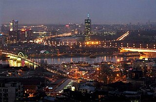
New Belgrade is a municipality of the city of Belgrade. It is the central business district in Serbia and one of the major ones in Southeast Europe. It was a planned municipality, built since 1948 in a previously uninhabited area on the left bank of the Sava river, opposite old Belgrade. In recent years, it has become the central business district of Belgrade and its fastest developing area, with many businesses moving to the new part of the city, due to more modern infrastructure and larger available space. With 212,104 inhabitants, it is the second most populous municipality of Serbia after Novi Sad.

Stari Grad, Belgrade Municipality in Belgrade, Serbia

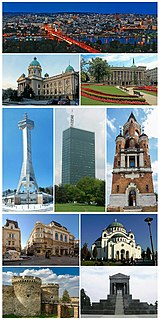
Stari Grad is a municipality of the city of Belgrade. It encompasses some of the oldest sections of urban Belgrade, thus the name. Stari Grad is one of the three municipalities that occupy the very center of Belgrade, together with Savski Venac and Vračar.

Donji Grad, Zemun Urban neighbourhood in Zemun, Belgrade, Serbia

Donji Grad is an urban neighborhood of Belgrade, the capital of Serbia. It is located in Belgrade's municipality of Zemun.

Galenika, Zemun Urban neighbourhood in Zemun, Belgrade, Serbia

Galenika or Nova Galenika is an urban neighborhood of Belgrade, the capital of Serbia. It is located in Belgrade's municipality of Zemun.

Gornji Grad, Zemun Urban neighbourhood in Zemun, Belgrade, Serbia

Gornji Grad is an urban neighborhood of Belgrade, the capital of Serbia. It is located in Belgrade's municipality of Zemun.

Kalvarija, Zemun

Kalvarija, also formerly known as Marija Bursać is an urban neighborhood of Belgrade, the capital of Serbia. It is located in Belgrade's municipality of Zemun.

Kolonija "B" Zmaj or colloquially Zmaj is an urban neighborhood of Belgrade, the capital of Serbia. It is located in Belgrade's municipality of Zemun.

Novi Grad, Zemun Urban neighbourhood in Zemun, Belgrade, Serbia

Novi Grad is an urban neighborhood of Belgrade, the capital of Serbia. It is located in Belgrade's municipality of Zemun.

Zemun Polje Urban neighbourhood in Zemun, Belgrade, Serbia

Zemun Polje is an urban neighborhood of Belgrade, the capital of Serbia. It is located in the municipality of Zemun.

Bežanija Urban neighbourhood in New Belgrade, Belgrade, Serbia

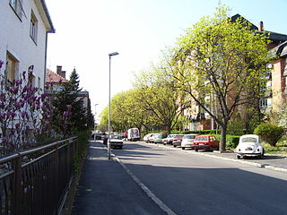
Bežanija is an urban neighborhood of Belgrade, the capital of Serbia. It is located in Belgrade's municipality of Novi Beograd, in the Syrmia region.

Ćukovac

Ćukovac is an urban neighborhood of Belgrade, the capital of Serbia. It is located in Belgrade's municipality of Zemun.

Retenzija is an urban neighborhood of Belgrade, the capital of Serbia. It is located in Belgrade's municipality of Zemun.

Sava Kovačević, Zemun

Sava Kovačević is an urban neighborhood of Belgrade, the capital of Serbia. It is located in Belgrade's municipality of Zemun.

Sava Kovačević (1905–1943) was a Yugoslav Partisan World War II commander.

Zemunski Kej Urban neighbourhood in Zemun, Belgrade, Serbia

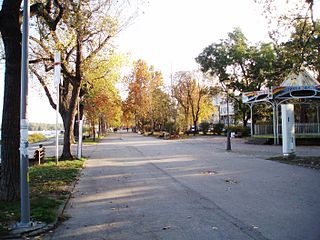
Zemunski Kej is an urban neighborhood of Belgrade, the capital of Serbia. It is located in Belgrade's municipality of Zemun.

Železnička Kolonija Urban neighbourhood in Zemun, Belgrade, Serbia

Železnička Kolonija is an urban neighborhood of Belgrade, the capital of Serbia. It is located in Belgrade's municipality of Zemun.

Paviljoni Urban neighbourhood in New Belgrade, Belgrade, Serbia

Paviljoni is an urban neighborhood of Belgrade, the capital of Serbia. It is located in Belgrade's municipality of Novi Beograd.

References

    Coordinates: 44°51′04″N20°22′09″E / 44.85111°N 20.36917°E / 44.85111; 20.36917