
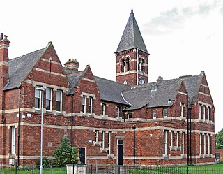
Sutton-in-Ashfield is a market town in Nottinghamshire, England, with a population of 48,527 in 2019. It is the largest town in the district of Ashfield, four miles west of Mansfield, 2 miles (3 km) from the Derbyshire border and 12 miles (19 km) north of Nottingham. It has a population of 48,527.
Bestwood Village is an area and civil parish in the Gedling district of Nottinghamshire. Until 1 April 2018 it was part of the civil parish of Bestwood St. Albans. A small part of the village falls within the Ashfield district council area. There have been several new housing estates built recently including the redevelopment of the former Bayles and Whylie factory site which was a former glue mill. It is to the east of Hucknall and north of Bulwell. It is neighboured to the north by the village of Papplewick. It is also close to the Bestwood Park Estate which is in the City of Nottingham.
Agecroft Colliery was a coal mine on the Manchester Coalfield that opened in 1844 in the Agecroft district of Pendlebury, Lancashire, England. It exploited the coal seams of the Middle Coal Measures of the Lancashire Coalfield. The colliery had two spells of use; the first between 1844 and 1932, when the most accessible coal seams were exploited, and a second lease of life after extensive development in the late 1950s to access the deepest seams.

The Maltby Main Colliery was a coal mine located 7 miles (11 km) east of Rotherham on the eastern edge of Maltby, South Yorkshire, England. The mine was closed in 2013.
Stanton Hill is a village in the Ashfield district of Nottinghamshire.

Kellingley Colliery, known affectionately as the 'Big K', was a deep coal mine in North Yorkshire, England, 3.6 miles (5.8 km) east of Ferrybridge power station. It was owned and operated by UK Coal.
The Elsecar Collieries were the coal mines sunk in and around Elsecar, a small village to the south of Barnsley in what is now South Yorkshire, but was traditionally in the West Riding of Yorkshire.
The South Yorkshire Coalfield is so named from its position within Yorkshire. It covers most of South Yorkshire, West Yorkshire and a small part of North Yorkshire. The exposed coalfield outcrops in the Pennine foothills and dips under Permian rocks in the east. Its most famous coal seam is the Barnsley Bed. Coal has been mined from shallow seams and outcrops since medieval times and possibly earlier.
Harworth Colliery was a colliery near the town of Harworth Bircotes in Bassetlaw, Nottinghamshire, England.
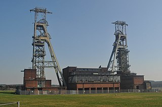
Clipstone Colliery was a coal mine in the village of Clipstone, Nottinghamshire, part of the area known as The Dukeries. The colliery opened in 1922 and operated until 2003. It was built by the Bolsover Colliery Company, transferred to the National Coal Board in 1947, then operated by RJB Mining from 1994. The headstocks and powerhouse are grade II listed buildings so have been preserved.

Pleasley Colliery is a former English coal mine. It is located to the north-west of Pleasley village, which sits above the north bank of the River Meden on the Nottinghamshire/Derbyshire border. It lies 3 miles (4.8 km) north of Mansfield and 9 miles (14.5 km) south of Chesterfield. From the south it commands a prominent position on the skyline, although less so now than when the winders were in operation and both chimney stacks were in place. The colliery is situated at about 500 ft (152m) above sea level and is aligned on a NE–SW axis following the trend of the river valley at this point.

Chatterley Whitfield Colliery is a disused coal mine on the outskirts of Chell, Staffordshire in Stoke on Trent, England. It was the largest mine working the North Staffordshire Coalfield and was the first colliery in the UK to produce one million tons of saleable coal in a year.
The South Waratah Colliery was a coal mine located at Charlestown, in New South Wales Australia.

Bickershaw Colliery was a coal mine, located on Plank Lane in Leigh, then within the historic county boundaries of Lancashire, England.
Mosley Common Colliery was a coal mine originally owned by the Bridgewater Trustees operating on the Manchester Coalfield after 1866 in Mosley Common, Greater Manchester, then in the historic county of Lancashire, England. The colliery eventually had five shafts and became the largest colliery on the Lancashire Coalfield with access to around 270 million tons of coal under the Permian rocks to the south.

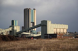
Thoresby Colliery was a coal mine in north Nottinghamshire on the outskirts of Edwinstowe village. The mine, which opened in 1925, was the last working colliery in Nottinghamshire when it closed in 2015. The site has been cleared and it being redeveloped as a housing estate.

Brinsley Colliery was a coal mine in west Nottinghamshire, close to the boundary with Derbyshire, in what is now Broxtowe district.
Hapton Valley Colliery was a coal mine on the edge of Hapton near Burnley in Lancashire, England. Its first shafts were sunk in the early 1850s and it had a life of almost 130 years, surviving to be the last deep mine operating on the Burnley Coalfield.
Brierley Forest Park, Sutton in Ashfield was designated a Local Nature Reserve in 2006. It contains Calcareous grassland, sown grassland, wildflower meadows with hoary ragwort, yellow-wort, wild carrot and lesser trefoil. There are four wetland feature areas, Brierley Waters, a reed swamp, Rooley Brook and the visitor centre pond. There are species rich hedgerows, woodland and semi natural vegetation.

Warsop Vale is a village in the Mansfield district of western Nottinghamshire, England. It is 18 miles (29 km) north of Nottingham, and 5 miles (8.0 km) north of Mansfield. It is in the civil parish of Warsop. Warsop Vale's heritage is primarily as a former mining village. It lies in the very picturesque area known as the Dukeries and is easily accessible to Clumber Park, Thoresby Park and hall, Rufford Park and the Earl of Portland estate of Welbeck, together all part of Sherwood Forest.

