Sutton Mill Dam

Last updated
The Sutton Mill Dam in Sutton, St Helens, England Mill dam22.jpg
The Sutton Mill Dam in Sutton, St Helens, England

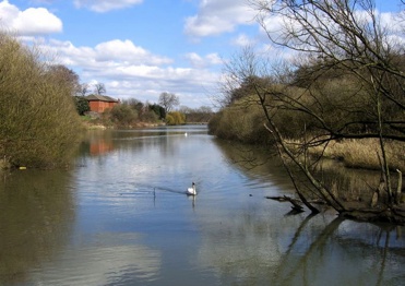
The Sutton Mill Dam is a wildlife nature park and area of open water located in Sutton in the south of St Helens in Merseyside, England. Sandwiched between Clock Face Road, Leach Lane, and Mill Lane, it measures 360 metres in length with a waterfall at its eastern end. [1] The lake is formed from the Sutton Brook, which flows through Sutton from Chester Lane to Jackson Street and ultimately into the St Helens Canal.

In 1976, local residents formed the Sutton Mill Dam Action Group to campaign against plans to allow the site to become a dumping ground for industrial waste. As a result of the local community's efforts, the site was officially opened as a wildlife park in 1987 with natural recovery encouraged as opposed to artificial landscaping.

The success of the project was recognised on 24 May 1988, when Prince Charles visited Sutton Mill Dam to the delight of a crowd of 200 onlookers.

The Sutton Mill Dam is one of the most popular angling locations in St Helens containing roach, bream, gudgeon and carp and the East Sutton Angling Club hosts popular summer contests for young anglers.

Sutton Mill Dam is owned by St Helens Council and a copy of the register of title can be obtained from HM Land Registry under title number MS184549.Land Register Online : Download Enquiry

Related Research Articles

Carshalton Human settlement in England

Carshalton is a town, with a historic village centre, in south London, England, within the London Borough of Sutton. It is situated 9.5 miles (15.3 km) south-southwest of Charing Cross, in the valley of the River Wandle, one of the sources of which is Carshalton Ponds in the middle of the village. Prior to the creation of Greater London in 1965, Carshalton was in the administrative county of Surrey.

River Otter, Devon river in Somerset and Devon, England

The River Otter rises in the Blackdown Hills just inside the county of Somerset, England near Otterford, then flows south through East Devon. It enters the English Channel at the western end of Lyme Bay, part of the Jurassic Coast, a UNESCO World Heritage Site. The Permian and Triassic sandstone aquifer in the Otter Valley is one of Devon's largest groundwater sources, supplying drinking water to 200,000 people.

The Moss

The Moss is a brook in North East Derbyshire, England.

Metropolitan Borough of St Helens Metropolitan borough in England

The Metropolitan Borough of St Helens is a metropolitan borough in the ceremonial county of Merseyside and historic county of Lancashire, in North West England. It is named after its largest town St Helens, and covers an area which also includes the settlements of Earlestown, Rainhill, Eccleston, Clock Face, Haydock, Billinge, Rainford and Newton-le-Willows.

River Wandle Tributary of the River Thames in south London

The River Wandle is a tributary of the River Thames in south London, England. With a total length of about 9 miles (14 km), the river passes through the London boroughs of Croydon, Sutton, Merton and Wandsworth, where it reaches the Thames. A short headwater – the Caterham Bourne – is in Surrey, the historic county of the river's catchment. Tributaries of the Wandle include the River Wrythe and the Norbury Brook.

River Rivelin River in South Yorkshire, England

The River Rivelin is a river in Sheffield, South Yorkshire, England.

St Helens, Merseyside Town in England

St Helens is a large town in Merseyside, England, with a population of 102,629. It is the administrative centre of the Metropolitan Borough of St Helens, which had a population of 176,843 at the 2001 Census.

Clock Face, St Helens Village in England

Clock Face is a village and area of St Helens, England, 5.6 km (3.5 mi) south of the town centre. It is a ward within the Metropolitan Borough of St Helens and forms part of the parish of Bold.

St Helens Junction railway station

St Helens Junction railway station is a railway station serving St Helens, Merseyside, England. It is in Sutton, three miles southeast of St Helens town centre. The station is on the electrified northern route of the Liverpool to Manchester Line, 12 miles (19 km) east of Liverpool Lime Street. The station and all trains calling there are presently operated by Northern Trains.

Eccleston, St Helens Village and Civil Parish in England

Eccleston is a civil parish in the Metropolitan Borough of St Helens, Merseyside, England. At the 2011 Census, it had a population of 10,433.

Roath Park

Roath Park Cardiff, Wales, is one of Cardiff's most popular parks, owned by Cardiff County Council and managed by the Parks Section. It retains a classic Victorian atmosphere and has many facilities. The park has recently been awarded the prestigious Green Flag award to recognise its high quality and its importance to Cardiff. Roath Park has widely diverse environments across the park.

Sherdley Park

Sherdley Park is a 336 acre urban park in Sutton, St Helens, Merseyside.

Montauk State Park

Montauk State Park is a public recreation area occupying nearly 3,000 acres (1,200 ha) at the headwaters of the Current River, fifteen miles (24 km) southwest of Salem, Missouri. The state park contains a fish hatchery and is noted for its rainbow and brown trout angling. It was acquired in 1926. The park has several natural springs including Montauk Spring with a daily average flow of 53 million gallons of water.

Blackburn Brook

The Blackburn Brook is a stream in Sheffield, South Yorkshire, England which flows through the Blackburn Valley along the M1 and Ecclesfield Road and joins the River Don near the Meadowhall shopping centre. Downstream from the A61 road at Chapeltown the Blackburn Brook is defined as a main river by the Environment Agency, which requires new building development to be at least 8m from the bank side as a flood defence measure and to allow access to the watercourse for maintenance.

Sutton, St Helens Location in England

Sutton is an area of St Helens, Merseyside, and Ward of the metropolitan borough of the same name. The population of the ward taken at the 2011 census was 12,003.

Forge Dam Park Park in Sheffield, South Yorkshire, England

Forge Dam Park is a park in Fulwood, in the city of Sheffield, South Yorkshire, England. Forge Dam Park is the fourth in a series of parks along the course of the Porter Brook. The 49 acres (20 ha) park is on the site of the Old Mayhouse Farm and Forge Dam. It was acquired by the J G Graves Charitable Trust in 1938.

Ponderosa (Sheffield)

The Ponderosa is a recreation area within the City of Sheffield, South Yorkshire, England. Although not a public park it was designated as Open Space by Sheffield City Council in the 1993 Unitary Development Plan. It covers an area of over 25 acres (10 ha) and is located at 53.3868°N 1.4865°W, 0.9 miles (1.5 km) west of the city centre between the districts of Upperthorpe and Netherthorpe. Although the name “Ponderosa” was originally an informal name given by local children, it is now the accepted title and is recognised by the local council. Along with Weston Park and Crookes Valley Park it is one of the three “Crookesmoor Parks”.

Shire Brook Valley Local Nature Reserve

The Shire Brook Valley Local Nature Reserve is located in Sheffield, England, on a former brownfield industrial site.

River Calder, West Yorkshire

The River Calder is in West Yorkshire, in Northern England.

Astbury Mere

Astbury Mere is a lake and open area in West Heath, a suburb of Congleton, Cheshire, England, in an area formerly quarried for silica sand. Part of the area is accredited by Natural England as a country park, Astbury Mere Country Park. The country park has an area of 14 hectares and the lake covers 43 acres (17 ha). The park is owned by Astbury Mere Trust, and the lake and its banks by Stoke-on-Trent Angling Society.

References

  1. "Sutton Mill Dam St Helens | Sutton Beauty & Heritage". www.suttonbeauty.org.uk.

Coordinates: 53°25′34″N2°43′01″W / 53.426°N 2.7170°W / 53.426; -2.7170