
Huarochirí Province or Waruchiri is located in the Lima Region of Peru. Its capital is Matucana. The western section is part of the Lima Metropolitan Area.
San Damian District is one of thirty-two districts of the Huarochirí Province in Peru.

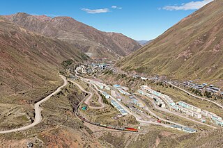
San Mateo District is one of thirty-two districts of the province Huarochirí in Peru.

Putka is a mountain in the Cordillera Central in the Andes of Peru, about 5,100 metres (16,732 ft) high. It is slocated in the Lima Region, Huarochirí Province, Chicla District.
Quñuq P'ukru is a mountain in the Cordillera Central in the Andes of Peru, about 5,000 m (16,404 ft) high. It is situated in the Lima Region, Huarochirí Province, Chicla District.
Yuraqqucha is a mountain in the Andes of Peru, about 5,100 metres (16,732 ft) high. It is located in the Junín Region, Yauli Province, Morococha District, and in the Lima Region, Huarochirí Province, Chicla District. Yuraqqucha lies northwest of a lake named Waqraqucha, the Antikuna mountain pass and the peak of Antikuna. Anta Q'asa, Sillaqaqa, Inka Kancha and Pukaqucha are situated west, southwest and northwest of Yuraqqucha.
Quri is a mountain in the Cordillera Central in the Andes of Peru, about 5,200 metres (17,060 ft) high. It is situated in the Lima Region, Huarochiri Province, San Mateo District, and in the Junín Region, Yauli Province, Yauli District. Quri lies west of the main branch of the Paryaqaqa or Waruchiri mountain range, southwest of a lake named Wallaqucha (Huallacocha).
Uqhu or Ukhu is a 5,262-metre-high (17,264 ft) mountain in the Cordillera Central in the Andes of Peru. It is located in the Lima Region, Huarochirí Province, on the border of the districts of San Damian and San Mateo. Uqhu is situated northwest of the mountain named Suyruqucha. A little lake called Suyruqucha lies at its feet.
Pukaqucha is a mountain in the Andes of Peru, about 5,100 metres (16,732 ft) high, at a small lake of the same name. The mountain is located in the Junín Region, Yauli Province, in the districts of Marcapomacocha and Morococha, and in the Lima Region, Huarochirí Province, Chicla District. It lies near the Antikuna pass, northwest of Yuraqqucha and northeast of Inka Kancha and Sillaqaqa.
Qunchupata is a mountain in the Andes of Peru, about 5,100 metres (16,732 ft) high. It is located in the Junín Region, Yauli Province, Marcapomacocha District, and in the Lima Region, Huarochirí Province, Chicla District. Qunchupata lies southwest of Anta Q'asa and Quriqucha and southeast of Yana Ulla. It is situated north of the Hatun Uqhu valley.

Suerococha is a mountain in the west of the Huayhuash mountain range in the Andes of Peru, about 5,100 metres (16,732 ft) high, and the name of a small lake near the mountain. The mountain is located in the Ancash Region, Bolognesi Province, Pacllon District. Suyruqucha lies on a sub-range west of Yerupaja, northwest of Huacrish and Auxilio and northeast of Rajucollota.
Suerococha is a mountain in the south of the Huayhuash mountain range in the Andes of Peru, about 5,000 metres (16,404 ft) high, and the name of a small lake near the mountain. The mountain is located in the Lima Region, Cajatambo Province, Cajatambo District. It lies east of Cuyoc.
Utush Mikhunan is a 5,228-metre-high (17,152 ft) mountain in the Cordillera Central in the Andes of Peru. It lies in the Lima Region, Huarochirí Province, on the border of the districts of San Damian and San Mateo. Utush Mikhunan is situated northwest of Uqhu and Suyruqucha.
Mulli is a mountain in the Cordillera Central in the Andes of Peru, about 5,000-metre (16,404 ft) high. It lies in the Lima Region, Huarochirí Province, San Damian District. It is situated on a ridge southwest of Utush Mikhunan is situated northwest of Uqhu and Suyruqucha.
Suyruqucha is a mountain in the Paryaqaqa or Waruchiri mountain range in the Andes of Peru, about 5,500 metres (18,045 ft) high. It is located in the Junín Region, Jauja Province, Canchayllo District, in the Yauli Province, Suitucancha District, and in the Lima Region, Huarochiri Province, Quinti District. It lies on the western border of the Nor Yauyos-Cochas Landscape Reserve. It is situated northwest of Qullqip'ukru. Wararayuq lies west of it.
Yana Yana is a 5,303-metre-high (17,398 ft) mountain in the Cordillera Central in the Andes of Peru. It is situated in the Lima Region, Huarochiri Province, on the border of the districts of Carampoma, Matucana and San Mateo, north of the Rimac River. Yana Yana lies southeast of Qarwa Ranra.
Uqsha Wallqa is a mountain in the Paryaqaqa mountain range in the Andes of Peru, about 5,000 metres (16,404 ft) high. It is situated in the Lima Region, Huarochirí Province, on the border of the districts of San Mateo and Quinti. It lies northwest of Paqcha and Wararayuq and southeast of Wamanripa.
Chakraqucha is a mountain, lying south of a small lake of the same name in the Cordillera Central in the Andes of Peru, about 4,600 m (15,100 ft) high. It is located in both the Lima Region, Huarochirí Province, Quinti District, and in the Yauyos Province, Tanta District.
The Yuraqmayu or Río Blanco is a 36.2 km long river in Peru located in the Lima Region, Huarochirí Province, in the districts of Chicla and San Mateo. It is a left tributary of the Rimac River which empties into the Pacific Ocean.


