Snåsa or Snåase is a municipality in Trøndelag county, Norway. It is part of the Innherred region. The administrative centre of the municipality is the village of Snåsa. Other villages include Agle and Jørstad.

Grong (help·info) is a municipality in Trøndelag county, Norway. It is part of the Namdalen region. The administrative centre of the municipality is the village of Medjå. Other villages in the municipality include Bergsmoen, Formofoss, Gartland, and Harran.

Høylandet is a municipality in Trøndelag county, Norway. It is part of the Namdalen region. The administrative centre of the municipality is the village of Høylandet. Other villages include Kongsmoen and Vassbotna.

Vuku is a village in the municipality of Verdal in Trøndelag county, Norway. It is located at the confluence of the rivers Helgåa and Inna where they become the Verdalselva river. The village is about 40 kilometres (25 mi) west of the village of Vera and about 15 kilometres (9.3 mi) east of the town of Verdalsøra. Vuku is also a parish covering the central part of Verdal municipality, with Vuku Church located in this village. The 0.22-square-kilometre (54-acre) village has a population (2017) of 234 which gives the village a population density of 1,064 inhabitants per square kilometre (2,760/sq mi).

Langørjan or Rye is a village in the municipality of Trondheim in Trøndelag county, Norway. The village is located in the borough of Heimdal in the Byneset district about 12 kilometres (7.5 mi) west of the city of Trondheim and about 7.5 kilometres (4.7 mi) north of the village of Spongdal. The 0.33-square-kilometre (82-acre) village has a population (2017) of 479 which gives the village a population density of 1,452 inhabitants per square kilometre (3,760/sq mi).

Muruvika or Muruvik is a village in the municipality of Malvik in Trøndelag county, Norway. The village is located near the end of the Stjørdalsfjorden, an arm of the Trondheimsfjord. The village sits about 3 kilometres (1.9 mi) north of the village of Hommelvik, the municipal centre.

Eidsvatnet is a lake on the border of the municipalities of Høylandet and Overhalla in Trøndelag county, Norway. The 15.87-square-kilometre (6.13 sq mi) lake lies about 5 kilometres (3.1 mi) northeast of the village of Skogmo. The lake empties into the river Bjøra which flows a short distance into the large river Namsen.
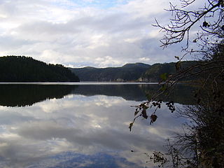
Storgrønningen is a lake in the municipality of Høylandet in Trøndelag county, Norway. The extreme southern tip of the lake crosses over the border into Overhalla municipality. The lake lies about 7.5 kilometres (4.7 mi) west of the village of Høylandet and about 4 kilometres (2.5 mi) southeast of the mountain Grønningfjella.
Bergsmoen or Bergsmo is a village in the municipality of Grong in Trøndelag county, Norway. The village is located about 5 kilometres (3.1 mi) west of Medjå, the municipal center of Grong. The village lies close to the river Namsen in the Namdalen valley.
Skogmo is a village in the municipality of Overhalla in Trøndelag county, Norway. It is located along the Norwegian County Road 17, about 4 kilometres (2.5 mi) northeast of the municipal centre, Ranemsletta. The village lies just north of the river Namsen and about 5 kilometres (3.1 mi) southwest of the lake Eidsvatnet.
Ranemsletta is the administrative centre of the municipality of Overhalla in Trøndelag county, Norway. The village is located on the north shore of the river Namsen, along the Norwegian County Road 17 which connects it to the town of Namsos and Grong. The now-defunct Namsos Line railway used to run through the village as well. The villages of Svalia and Skogmo are neighboring villages to the north and northeast.
Skage or Hunn is a village in the municipality of Overhalla in Trøndelag county, Norway. It is located on the northern shore of the river Namsen, about 10 kilometres (6.2 mi) west of the municipal center, Ranemsletta, and about 15 kilometres (9.3 mi) east of the town of Namsos.
Trolla is a village in the municipality of Trondheim in Trøndelag county, Norway. It is located in the Midtbyen borough, along the Trondheimsfjord on the north coast of the Bymarka area. It is about 10 kilometres (6.2 mi) northeast of the village of Langørjan and about 4 kilometres (2.5 mi) northwest of the Ila neighborhood in the city of Trondheim. The 0.24-square-kilometre (59-acre) village has a population (2017) of 511 which gives the village a population density of 2,129 inhabitants per square kilometre (5,510/sq mi).
Spongdal is a village in the municipality of Trondheim in Trøndelag county, Norway. It is the largest village in the Byneset area in Heimdal borough. It is located between the villages of Langørjan and Ringvål. The 0.27-square-kilometre (67-acre) village has a population (2017) of 556 which gives the village a population density of 2,059 inhabitants per square kilometre (5,330/sq mi). The Byneset Church lies about 2.5 kilometres (1.6 mi) west of the village of Spongdal.

Hommelvik is the administrative centre of the municipality of Malvik in Trøndelag county, Norway. The village is located at the end of the Hommelvika, a bay off of the Trondheimsfjord. Hommelvik is about 2.5 kilometres (1.6 mi) southwest of the village of Muruvika, about 4 kilometres (2.5 mi) southeast of the village of Smiskaret, about 8 kilometres (5.0 mi) east of the village of Vikhammer, and about 10 kilometres (6.2 mi) north of the village of Sneisen. The river Homla runs north through the village, emptying into the fjord. The name of the village is derived from the river name.
Sævik or Sævig is a small village in the municipality of Namsos in Trøndelag county, Norway. The village was the site of the old Sævik Church until the mid-1800s. The village is located about half-way between the villages of Klinga and Spillum, along the Norwegian County Road 17. The town of Namsos lies about 5 kilometres (3.1 mi) to the north, on the other side of the river Namsen.
Bratsberg is a village in Trondheim municipality in Trøndelag county, Norway. The village is located in the borough of Lerkendal, between the village of Tanem and the lake Jonsvatnet. The 0.26-square-kilometre (64-acre) village has a population (2017) of 409 which gives the village a population density of 1,573 inhabitants per square kilometre (4,070/sq mi).
Øysletta is a village in the municipality of Overhalla in Trøndelag county, Norway. It is located on the south shore of the river Namsen, along the now-defunct Namsos Line railway. The municipal center, Ranemsletta lies about 7.5 kilometres (4.7 mi) to the northwest and the municipal border with Grong lies about 3 kilometres (1.9 mi) east of Øysletta.