
Hægebostad is a municipality in Vest-Agder county, Norway. It is located in the traditional district of Lister. The administrative centre of the municipality is the village of Tingvatn. Other villages in Hægebostad include Eiken, Haddeland, and Snartemo. The municipality encompasses the northern end of the Lyngdalen valley which follows the river Lygna.

Audnedal is a municipality in Vest-Agder county, Norway. It is located in the traditional district of Sørlandet. The administrative centre of the municipality is the village of Konsmo. Other villages in Audnedal include Byremo and Vivlemo. The municipality encompasses the upper half of the Audnedalen valley, and the municipality of Lindesnes covers the southern half of the valley.

Farsund (help·info) is a municipality in Vest-Agder county, Norway. It is located in the traditional district of Lister. The administrative centre of the municipality is the town of Farsund. Farsund is a coastal municipality in the far southwestern part of Norway, bordering Kvinesdal municipality in the north and Lyngdal in the north and east.
Fleseland is a small village in Lyngdal municipality in Vest-Agder county, Norway. The village is located on the west shore of the Lenesfjorden, about 10 kilometres (6.2 mi) southeast of the town of Lyngdal and about 6 kilometres (3.7 mi) north of the village of Høllen in Lindesnes municipality.

Southern Norway is the geographical region (landsdel) along the Skagerrak coast of southern Norway. The region is an informal description since it does not have any governmental function. It roughly corresponds to the old petty kingdom of Agder as well as the two present-day counties of Vest-Agder and Aust-Agder. The total combined area of Vest-Agder and Aust-Agder counties is 16,493 square kilometres (6,368 sq mi). The name is relatively new, having first been used in Norway around 1900.

Hæåk is a very small farming village in Lyngdal municipality in Vest-Agder county, Norway. The village is located about 8 kilometres (5.0 mi) northwest of the town of Lyngdal. Originally, the farm was not accessible by road, and only a few farmers lived there. However, in 1987 a steep road leading down to Hæåk was built, and it has since become a popular place for bicycling enthusiasts.
Krossen is a village in Mandal municipality in Vest-Agder county, Norway. The village is located in the Mandalen valley, on the western shore of the river Mandalselva, about 10 kilometres (6.2 mi) north of the town of Mandal and about 9 kilometres (5.6 mi) south of the village of Øyslebø.
Skomrak is a village in Lyngdal municipality in Vest-Agder county, Norway. The village is located near the northern end of the Rosfjorden, about 1.5 kilometres (0.93 mi) south of the town of Lyngdal. The village of Svenevik lies about 2 kilometres (1.2 mi) straight west across the fjord.
Øyslebø is a village in Marnardal municipality in Vest-Agder county, Norway. The village is located in the Mandalen valley along the Mandalselva river, about 21 kilometres (13 mi) north of the town of Mandal. The Sørlandet Line passes the village to the north, stopping at the Marnardal Station, about 5 kilometres (3.1 mi) north of Øyslebø on the north side of the village of Heddeland. Øyslebø was the administrative centre of the old municipality of Øyslebø which existed from 1899 until 1964.
Ytre Øydnavatnet is a lake in the municipality of Audnedal in Vest-Agder county, Norway. The 3.22-square-kilometre (1.24 sq mi) lake is located along the river Audna, just south of the lake Øvre Øydnavatnet. The lake sits at an elevation of 96 metres (315 ft) above sea level. The 17.5-kilometre (10.9 mi) long lake lies about 5.5 kilometres (3.4 mi) south of the village of Byremo and about 3.6 kilometres (2.2 mi) north of the village of Konsmo.

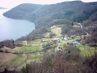
Kvås is a village in Lyngdal municipality in Vest-Agder county, Norway. The village is located in the Lyngdalen valley, along the river Lygna, about 16 kilometres (9.9 mi) northeast of the municipal centre of Alleen and about 10 kilometres (6.2 mi) west of the village of Konsmo in Audnedal. The Kvås Church lies at the center of the village. Kvås was the administrative centre of the old municipality of Kvås from 1909 until its dissolution in 1963.

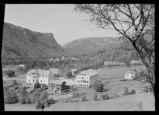
Austad is a village in Lyngdal municipality in Vest-Agder county, Norway. The village is located in the southern part of Lyngdal, about 6 kilometres (3.7 mi) south of the town of Lyngdal and the village of Korshamn. The village is on the eastern shore of the Rosfjorden. Austad Church is located in the center of the village. The village was the administrative centre of the old municipality of Austad which existed from 1909 until 1963.

Korshamn or Korshavn is a fishing village in the southern part of Lyngdal municipality in Vest-Agder county, Norway. The village is located on the island of Revøy, located at the mouth of the Grønsfjorden. Korshamn lies about 10 kilometres (6.2 mi) south of the village of Austad. Korshamn Chapel is located in the village, serving the southern part of the municipality. Traditionally, this was just a fishing village, but it now caters to tourists, primarily through the "Korshamn Rorbuer" rental cottages.

Hægeland or Hægelandskrossen is a village in Vennesla municipality in Vest-Agder county, Norway. The village is located along the northeastern shore of the lake Hægelandsvatnet, a short distance south of the Kilefjorden. The Norwegian National Road 9 runs north-south through the village, just past Hægeland Church. The village of Bjelland lies about 15 kilometres (9.3 mi) to the east and the villages of Skarpengland and Øvrebø both lie about 15 kilometres (9.3 mi) to the south. The village of Øvre Eikeland lies about 2 kilometres (1.2 mi) southeast of Hægeland, along the Rv9 highway.

Liknes is the administrative centre of Kvinesdal municipality in Vest-Agder county, Norway. The village is located along the river Kvina, about 5.5 kilometres (3.4 mi) north of the mouth where it empties into the Fedafjorden. The village of Storekvina lies about 7 kilometres (4.3 mi) to the north of Liknes. The 1.97-square-kilometre (490-acre) village has a population (2015) of 2,462 which gives the village a population density of 1,250 inhabitants per square kilometre (3,200/sq mi).

Alleen or Lyngdal is a town which is the administrative centre of the municipal of Lyngdal in Vest-Agder county, Norway. It lies along the east side of the river Lygna, just north of the head of the Rosfjorden and northeast of the head of the Lyngdalsfjorden. The small villages of Skomrak and Svenevik both lie just south of the town and the small farming area of Hæåk lies about 8 kilometres (5.0 mi) to the northwest. On 1 January 2001, the municipal government declared the urban area of Alleen to be a town called Lyngdal. Both names are used to refer to the urban area.
Lygna or Lyngdalselva is a river in Vest-Agder county, Norway. The 82.2-kilometre (51.1 mi) river runs from the mountains in northern Hægebostad municipality, through the Lyngdalen valley to the municipality of Lyngdal to its mouth at Alleen, where it runs into Lyngdalsfjorden. Lygna has a discharge of 35.9 cubic metres per second (1,270 cu ft/s), and a drainage basin covering 664.3 square kilometres (256.5 sq mi). The river is called the Storåni north of the lake Lygne. The river passes the villages of Tingvatn, Snartemo, and Kvås as well as the town of Lyngdal.
Kvås is a former municipality in Vest-Agder county, Norway. The 116-square-kilometre (45 sq mi) municipality existed from 1909 until its dissolution in 1963. The municipality today makes up the northern third of the present-day municipality of Lyngdal. The administrative centre of Kvås was the village of Kvås where Kvås Church is located. Other villages in the Kvås area are Birkeland and Moi.
Vennesla is the administrative centre of Vennesla municipality in Vest-Agder county, Norway. The village is located in the upper Torridal valley along the river Otra, about 15 kilometres (9.3 mi) north of the city of Kristiansand. The village itself extends for about 10 kilometres (6.2 mi) along both sides of the river. The Norwegian National Road 9 passes through Mosby, about 6 kilometres (3.7 mi) south of Vennesla. The Sørlandsbanen railway line passes through Vennesla, stopping at Vennesla Station. The lake Venneslafjorden is located on the river Otra in the northern part of the village of Vennesla.


