

Svobodny Urban Okrug is the name of several municipal formations in Russia. The following administrative divisions are incorporated as such:
Svobodny Urban Okrug is the name of several municipal formations in Russia. The following administrative divisions are incorporated as such:
Kirovsky District is the name of several administrative and municipal divisions in Russia. The districts are generally named for Sergey Kirov, a Soviet statesman.
Alexeyevsky District is the name of several administrative and municipal districts in Russia. The districts' name generally derives from or is related to the male first name Alexey.

Krasnoyarsky District is the name of several administrative and municipal districts in Russia:

Kuybyshevsky District is the name of several administrative and municipal districts in Russia. The districts are generally named for Valerian Kuybyshev, a Soviet statesman.
Sovetsky District is the name of several administrative and municipal divisions in Russia. The name literally means "Soviet".
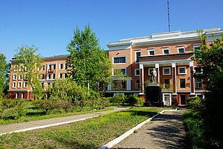
Svobodny is a town in Amur Oblast, Russia, located on the right bank of the Zeya River, 167 kilometers (104 mi) north of Blagoveshchensk, the administrative center of the oblast. Population: 58,778 (2010 Census); 63,889 ; 80,006 (1989 Soviet census).

Yubileyny was a town in Moscow Oblast, Russia, located 7 kilometers (4.3 mi) northeast of the Moscow Ring Road by Yaroslavl Highway, on the Klyazma River. It was merged into the surrounding city of Korolyov effective June 2014. Population: 33,237 (2010 Census); 30,837 (2002 Census).
Promyshlenny City District is the name of several city divisions in Russia. The name literally means "industrial".

Tsentralny District is the name of several administrative and municipal divisions in Russia. The name literally means "Central".

Raduzhny is a closed town in Vladimir Oblast, Russia, located on the Pol, Buzha, and Uzhbol Rivers, 12 kilometers (7.5 mi) south of Vladimir. Population: 17,569 (2021 Census); 18,211 (2010 Census); 17,506 (2002 Census).
Leninsky District is the name of several administrative and municipal divisions in Russia. The districts are named after Vladimir Lenin, the founder of the Soviet state.

Raduzhny Urban Okrug is the name of several municipal formations in Russia. The following administrative divisions are incorporated as such:

Fokino Urban Okrug is the name of several municipal formations in Russia. The following administrative divisions are incorporated as such:
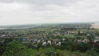
Svobodnensky District is an administrative and municipal district (raion), one of the twenty in Amur Oblast, Russia. The area of the district is 7,318 square kilometers (2,825 sq mi). Its administrative center is the town of Svobodny. Population: 14,315 (2010 Census); 14,568 ; 16,879 (1989 Soviet census).

Beloyarsky District is an administrative district (raion), one of the thirty in Sverdlovsk Oblast, Russia. Its administrative center is the urban locality of Beloyarsky. Population: 39,374 ; 39,312 (2002 Census); 69,251 (1989 Soviet census). The population of the administrative center accounts for 32.0% of the district's total population.
Nevyansky District is an administrative district (raion), one of the thirty in Sverdlovsk Oblast, Russia. The area of the district is 1,967 square kilometers (759 sq mi). Its administrative center is the town of Nevyansk. Population : 22,833 ; 24,516 (2002 Census); 31,345 (1989 Soviet census).
Shalinsky District is an administrative district (raion), one of the thirty in Sverdlovsk Oblast, Russia. The area of the district is 4,852 square kilometers (1,873 sq mi). Its administrative center is the urban locality of Shalya. Population: 23,834 ; 26,019 (2002 Census); 31,384 (1989 Soviet census). The population of Shalya accounts for 27.0% of the district's total population.

Sysertsky District is an administrative district (raion), one of the thirty in Sverdlovsk Oblast, Russia. Its administrative center is the town of Sysert. The district's population was 77,691 as of the, down from 78,085 (2002 Census); and 78,229 (1989 Soviet census). The population of Sysert accounts for 59.0% of the district's total population.

Verkhotursky District is an administrative district (raion), one of the thirty in Sverdlovsk Oblast, Russia. As a municipal division, it is incorporated as Verkhotursky Urban Okrug. Its administrative center is the town of Verkhoturye. Population: 16,802 ; 19,153 (2002 Census); 21,277 (1989 Soviet census). The population of Verkhoturye accounts for 52.5% of the district's total population.
Gubkinsky Urban Okrug is a municipal formation in Belgorod Oblast, Russia, one of the three urban okrugs in the oblast. Its territory comprises the territories of two administrative divisions of Belgorod Oblast—Gubkinsky District and the town of oblast significance of Gubkin.
| | This Russian location article is a stub. You can help Wikipedia by expanding it. |