Related Research Articles

Womens Bay is a census-designated place (CDP) in Kodiak Island Borough, Alaska, United States. At the 2020 census the population was 743, up from 719 in 2010. The name is correctly spelled "Womens", without an apostrophe.
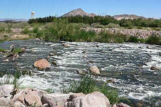
Las Vegas Wash is a 12-mile-long channel which feeds most of the Las Vegas Valley's excess water into Lake Mead. The wash is sometimes called an urban river, and it exists in its present capacity because of an urban population. The wash also works in a systemic conjunction with the pre-existing wetlands that formed the oasis of the Las Vegas Valley. The wash is fed by urban runoff, shallow ground water, reclaimed water used on parks and golf courses, and stormwater.

Federal Highway 1 is a free (libre) part of the federal highway corridors of Mexico, and the highway follows the length of the Baja California Peninsula from Tijuana, Baja California, in the north to Cabo San Lucas, Baja California Sur, in the south. The road connects with Via Rapida, which merges into the American Interstate 5 (I-5) at the San Ysidro Port of Entry, which crosses the international border south of San Ysidro, California.

Las Vegas Bay is a bay at the western edge of Lake Mead in the U.S. state of Nevada. The bay is located within the Lake Mead National Recreation Area to the northeast of the city of Henderson, Nevada, near the junction of Lake Mead Drive and Lake Mead Boulevard. A public campground and boat access are available in Las Vegas Bay. Low water levels of Lake Mead have rendered the marina there inoperable, and it has moved to the Hemenway Boat Harbor, in the south end of the Boulder Basin. The launch ramp there has also been closed due to the water levels.
Biscay Bay is a local service district in the Canadian province of Newfoundland and Labrador.

Kincora is a residential neighbourhood in the northwest quadrant of Calgary, Alberta, Canada. Located near the north edge of the city, it is bounded by the Sherwood community across Shaganappi Trail to the west, the Sage Hill community across 128 Avenue N.W. to the north, the Evanston community across Symons Valley Road to the east, and the Hidden Valley community across Stoney Trail to the south. It is one of five communities located within the Symons Valley area.
The 1993 Detroit Lions season was the 64th season in franchise history. The Lions improved from the 1992 season, and finished 10-6 and winning the NFC Central Division for the second time in three years.
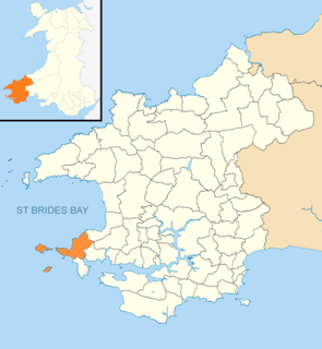
Marloes and St. Brides is a community in the West Wales county of Pembrokeshire.
The Maury Mountain Forest Reserve was established by the U.S. Forest Service in Oregon on June 2, 1905 with 54,220 acres (219.4 km2). On March 2, 1907 the forest was combined with Blue Mountains National Forest and the name was discontinued. The lands are presently divided among several Oregon Forests.
Cassia National Forest was established as the Cassia Forest Reserve in Idaho by the U.S. Forest Service on June 12, 1905 with 326,260 acres (1,320.3 km2). It became a National Forest on March 4, 1907. On July 1, 1908 it was combined with Raft River National Forest to establish Minidoka National Forest, when the name was discontinued. The land is now part of Sawtooth National Forest.
Minidoka National Forest was established in Idaho and Utah on July 1, 1908 with 736,407 acres (2,980.13 km2) from consolidation of Cassia National Forest and Raft River National Forest, primarily in Idaho. On July 1, 1953 Minidoka was absorbed by Sawtooth National Forest and is now the Sawtooth's Minidoka Ranger District.
Chelan National Forest was established in Washington by the U.S. Forest Service on July 1, 1908 with 2,492,500 acres (10,087 km2) from a portion of Washington National Forest. On July 1, 1921 it absorbed the first Okanogan National Forest, but on March 23, 1955 the name was changed back to Okanogan.
Tusayan National Forest was established by the U.S. Forest Service in Arizona on July 1, 1910 with 1,830,487 acres (7,407.72 km2) from part of Coconino National Forest and other lands. On October 22, 1934 the entire forest was transferred to Kaibab National Forest and the name was discontinued.
The Grand Cañon Forest Reserve was established by the General Land Office in Arizona on February 20, 1893 with 1,851,250 acres (7,491.7 km2). It was renamed Grand Canyon on August 8, 1906 and transferred to the U.S. Forest Service becoming a National Forest on March 4, 1907. On July 1, 1908 the entire forest was divided between Coconino National Forest and the newly established Kaibab National Forest, while other areas were returned to public lands, and the name was discontinued.

Mumianwan station is a station of Line 3, Shenzhen Metro. It was opened on 28 December 2010.
Callville Wash is an ephemeral stream or wash in Clark County, Nevada. It was named for Callville the riverport settlement founded in 1866, at its mouth where it had its original confluence with the Colorado River.
West End Wash is an ephemeral stream or wash in Clark County, Nevada. Its mouth is at its confluence with the Callville Wash of Lake Mead at an elevation 1,250 feet / 381 meters at when Lake Mead is at its full level. Currently as the reservoir is at a much lower level its mouth is found at approximately 36°08′24″N114°42′57″W. Its source is at 36°15′55″N114°43′58″W at 3,083 feet / 940 meters in the Gale Hills.
Gypsum Wash is an ephemeral stream or wash in Clark County, Nevada. Gypsum Wash was originally a tributary of Las Vegas Wash before the formation of Lake Mead which submerged their confluence under Las Vegas Bay. Due to the lowering of the reservoir over recent years Gypsum Wash is once again a tributary of Las Vegas Wash, now exposed at 36°07′04″N114°50′54″W at an elevation of 1085 feet. When Las Vegas Bay is at its full level, Gypsum Wash flows into Lower Gypsum Wash Cove at 36°07′43″N114°51′26″W at an elevation of 1,204 feet / 367 meters.
Boulder Basin is the westernmost of the three basins occupied by the Lake Mead reservoir and lies within the boundaries of Clark County, Nevada and Mohave County, Arizona. It includes the area between Hoover Dam and the mouth of Boulder Canyon at Auxiliary Point. When the reservoir is full it reaches an elevation of 1,204 feet / 367 meters. It includes Las Vegas Bay, Swallow Bay, Callville Bay and Hamblin Bay.
References
Coordinates: 36°07′12″N114°44′35″W / 36.120°N 114.743°W
| | This Clark County, Nevada state location article is a stub. You can help Wikipedia by expanding it. |