
Saysutshun Provincial Park, formally known as Newcastle Island Marine Provincial Park, is a provincial park located on a small island off the coast of Nanaimo, British Columbia, Canada.

The Fox River is a river in eastern Wisconsin in the Great Lakes region of the United States. It is the principal tributary of Green Bay, and via the Bay, the largest tributary of Lake Michigan. The city of Green Bay, one of the first European settlements in the interior of North America, is on the river at its mouth on lower Green Bay.

Powell River is a city on the northern Sunshine Coast of southwestern British Columbia, Canada. Most of its population lives near the eastern shores of Malaspina Strait, which is part of the larger Georgia Strait between Vancouver Island and the Mainland. With two intervening long, steep-sided fjords inhibiting the construction of a contiguous road connection with Vancouver to the south, geographical surroundings explain Powell River's remoteness as a community, despite relative proximity to Vancouver and other populous areas of the BC Coast. The city is the location of the head office of the qathet Regional District.

Noti is an unincorporated community in Lane County, Oregon, United States, located in the foothills of the Central Oregon Coast Range between Eugene and Florence. Per the 2000 census, Noti had a total population of 699.
Crofton is a small west coast town within the District of North Cowichan of southern Vancouver Island in British Columbia, east of BC Highway 1 about 74 kilometres (46 mi) north of Victoria.
Dalhousie is a former town located in Northern New Brunswick. On January 1, 2023, Dalhousie merged with the village of Charlo and all or part of five local service districts (LSDs) to form the new town of Heron Bay, named Baie-des-Hérons in French. Heron Bay is New Brunswick's northernmost point of land.
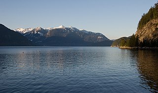
Howe Sound is a roughly triangular sound, that joins a network of fjords situated immediately northwest of Vancouver, British Columbia, Canada. It was designated as a UNESCO Biosphere Reserve in 2021.
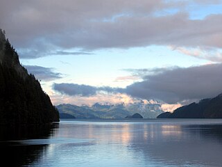
Toba Inlet is one of the lesser, but still principal, inlets of the British Columbia Coast. It is fourth in the series north from the 49th parallel which begins with Burrard Inlet, which is the harbour for the city of Vancouver. Between it and Jervis Inlet to its east, however, there is a freshwater fjord, Powell Lake, which has been augmented by a small hydro project to supply power to the large pulp mill at Powell River, the principal town of the Malaspina Peninsula of the upper Sunshine Coast. Klahoose 1 Reserve, of the Klahoose First Nation is at the mouth of Toba River at the Head of Toba Inlet. Toba Inlet and the Toba Valley is home to many grizzly bears.
Bamberton Provincial Park is a provincial park located in Mill Bay, British Columbia, Canada. The park area consists of a beach that borders on Saanich Inlet, and is connected to a camping area by several trails. The traditional name of the beach is qʷələs in the Saanich dialect. It shares its name with the now abandoned company town of Bamberton.
Kilby Provincial Park is a provincial park in British Columbia, Canada. Kilby Park is located in Harrison Mills, on the Harrison River overlooking Harrison Bay in the Upper Fraser Valley of southwestern British Columbia. It comprises 3 hectares with 30 campsites and a boat launch. The park offers a sandy summer beach and fall/winter viewing of bald eagles and migrating trumpeter swans from Alaska.
Santa Gertrudis-Boca del Infierno Provincial Park, legally Santa-Boca Provincial Park, is a provincial park on Nootka Island in British Columbia, Canada. It was established on 30 April 1996 to protect and Santa Gertrudis Cove and Boca del Infierno Bay, which are located on the southeastern shore of Nootka Island.

Sugarbowl-Grizzly Den Provincial Park and Protected Area is a provincial park in British Columbia, Canada.

Port Alice is a village of approximately 739 located on Neroutsos Inlet, southwest of Port McNeill, on Vancouver Island, originally built by Whalen Pulp and Paper Mills of Vancouver. The community is known for its natural environment, pulp mill, and salt water fishing.
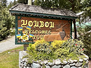
Youbou is a community located on the north shore of Cowichan Lake, west of Duncan and a 15-minute (13 km) drive west of the community of Lake Cowichan, Canada. The former mill town on Vancouver Island provides a public beach and extensive recreational opportunities, including fishing, boating, and hiking.
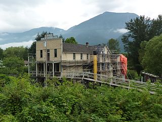
Woodfibre, originally Britannia West, was a pulp mill and at one time a small company town, on the west side of upper Howe Sound near Squamish, British Columbia. The mill closed in March 2006.

Langdale is a small residential community in British Columbia, Canada, located within the territory of the Squamish Nation, and part of West Howe Sound, Electoral Area F within the Sunshine Coast Regional District (SCRD).
Darrell Bay, formerly Shannon Bay, is a bay and associated ferry terminal and unincorporated settlement on the northeast coast of Howe Sound to the south of Squamish, British Columbia, Canada. It is adjacent to Shannon Falls Provincial Park, which lies immediately across BC Highway 99. Known locally as Shannon Bay until 1949, after William Shannon, one of the original landholders in the vicinity and the namesake of Shannon Falls, it was renamed by the Hydrographic Service as the result of a petition from Darrell Burgess, who owned a fishing camp at this spot. No reason was indicated why the established local name was not submitted by the Hydrographic Service.
The Sq'éwlets First Nation (Scowlitz) is the band government of Skaulits subgroup of the Stó:lō people located on Harrison Bay in the Upper Fraser Valley region between Chehalis (E) and Lake Errock, British Columbia, Canada (W). They are a member government of the Stó:lō Tribal Council.
Spruce is a ghost town in Pocahontas County, West Virginia, United States. Spruce is 9.5 miles (15.3 km) southwest of Durbin.
Dellwood is an unincorporated community in Coos County, Oregon, United States. It is about 12 miles (19 km) east of Coos Bay, east of Oregon Route 241 on the South Fork Coos River.

