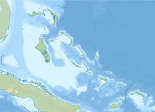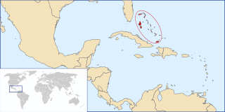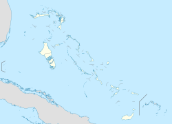
The Bahamas, known officially as the Commonwealth of The Bahamas, is a country within the Lucayan Archipelago of the West Indies in the Atlantic. It takes up 97% of the Lucayan Archipelago's land area and is home to 88% of the archipelago's population. The archipelagic state consists of more than 700 islands, cays, and islets in the Atlantic Ocean, and is located north of Cuba and northwest of the island of Hispaniola and the Turks and Caicos Islands, southeast of the US state of Florida, and east of the Florida Keys. The capital is Nassau on the island of New Providence. The Royal Bahamas Defence Force describes The Bahamas' territory as encompassing 470,000 km2 (180,000 sq mi) of ocean space.
This article talks about transportation in the Bahamas, a North American archipelagic state in the Atlantic Ocean.

The Abaco Islands lie in the northern Bahamas, 180 miles off the South Florida coast. They comprise the main islands of Great Abaco and Little Abaco, along with smaller barrier cays. The northernmost are Walker's Cay, and its sister island Grand Cay. To the south, the next inhabited islands are Spanish Cay and Green Turtle Cay, with its settlement of New Plymouth, Great Guana Cay, private Scotland Cay, Man-O-War Cay, and Elbow Cay, with its settlement of Hope Town. Southernmost are Tilloo Cay and Lubbers Quarters. Another of note off Abaco's western shore is onetime Gorda Cay, now a Disney Island and cruise ship stop and renamed Castaway Cay. Also in the vicinity is Moore's Island. On the Big Island of Abaco is Marsh Harbour, the Abacos' commercial hub and the Bahamas' third largest city, plus the resort area of Treasure Cay. Both have airports. A few mainland settlements of significance are Coopers Town and Fox Town in the north and Cherokee and Sandy Point in the south. Administratively, the Abaco Islands constitute seven of the 31 Local Government Districts of the Bahamas: Grand Cay, North Abaco, Green Turtle Cay, Central Abaco, South Abaco, Moore's Island, and Hope Town.

Grand Bahama is the northernmost of the islands of the Bahamas, with the town of West End located 56 nautical miles east of Palm Beach, Florida. It is the third largest island in the Bahamas island chain of approximately 700 islands and 2,400 cays. The island is roughly 530 square miles (1,400 km2) in area and approximately 153 kilometres (95 mi) long west to east and 24 kilometres (15 mi) at its widest point north to south. Administratively, the island consists of the Freeport Bonded Area and the districts of East Grand Bahama and West Grand Bahama. Nearly half of the homes on the island were damaged or destroyed in early September 2019 by Hurricane Dorian.

Freeport is a city, district and free trade zone on the island of Grand Bahama of the northwest Bahamas. In 1955, Wallace Groves, a Virginian financier with lumber interests in Grand Bahama, was granted 20,000 hectares of pineyard with substantial areas of swamp and scrubland by the Bahamian government with a mandate to economically develop the area. Freeport has grown to become the second most populous city in the Bahamas.

Ragged Island is a small island 23 km2 (8.9 sq mi) and district in the southern Bahamas. Ragged Island is part of the Jumentos Cays and Ragged Island Chain. The crescent-shaped chain measures over 180 km (110 mi) in length and includes cays known as Raccoon Cay, Hog Cay and Double-Breasted Cay. On 8 September 2017, Duncan Town took a direct hit from Hurricane Irma.

East Grand Bahama is a district of the Bahamas, situated on the eastern part of the island of Grand Bahama.

Man-O-War Cay is a small island in the Abaco region of the Bahamas. It had a population of 215 at the 2010 census.

Grand Cay is one of the districts of the Bahamas. It is geographically located in the Abaco Islands.

The Bahama Banks are the submerged carbonate platforms that make up much of the Bahama Archipelago. The term is usually applied in referring to either the Great Bahama Bank around Andros Island, or the Little Bahama Bank of Grand Bahama Island and Great Abaco, which are the largest of the platforms, and the Cay Sal Bank north of Cuba. The islands of these banks are politically part of the Bahamas. Other banks are the three banks of the Turks and Caicos Islands, namely the Caicos Bank of the Caicos Islands, the bank of the Turks Islands, and wholly submerged Mouchoir Bank. Farther southeast are the equally wholly submerged Silver Bank and Navidad Bank north of the Dominican Republic.

An ocean bank, sometimes referred to as a fishing bank or simply bank, is a part of the seabed that is shallow compared to its surrounding area, such as a shoal or the top of an underwater hill. Somewhat like continental slopes, ocean bank slopes can upwell as tidal and other flows intercept them, sometimes resulting in nutrient-rich currents. Because of this, some large banks, such as Dogger Bank and the Grand Banks of Newfoundland, are among the richest fishing grounds in the world.
Flamingo Air is a small airline in the Bahamas. Its base of operations is the Grand Bahama International Airport in Freeport. It also has offices in Marsh Harbour Abaco Airport, in Bimini International Airport, and in the Lynden Pindling International Airport, Nassau. It provides scheduled service to several islands, as well as Air Charter service to the Bahamas and south Florida.

Cay Sal Bank is the third largest and the westernmost of the Bahama Banks. It is located between 23º27'N - 24º10'N and 079º25'W – 080º35'W. In a geographical sense, it is separate from the Bahamas proper as it is much closer to Cuba than to the closest Bahamanian island. It is separated by Santaren Channel from the Great Bahama Bank, the western rim of which is 50 km (31 mi) to the east. The Straits of Florida separate it from the United States mainland and the Florida Keys.

The following outline is provided as an overview of and topical guide to The Bahamas:

Walker's Cay is the northernmost island in the Bahamas, part of the North Abaco district. Once a popular sport fishing location, the island has been deserted since 2004, following severe hurricane damage. The island is currently undergoing renovation under new ownership.

The Old Bahama Channel is a strait of the Caribbean region, between Cuba and the Bahamas.

The following is an alphabetical list of topics related to the British Overseas Territory of the Turks and Caicos Islands.

The following is an alphabetical list of topics related to the Commonwealth of The Bahamas.

The Bahama Archipelago, also known as the Lucayan Archipelago, is an island group comprising the Commonwealth of The Bahamas and the British Overseas Territory of the Turks and Caicos Islands. The archipelago is in the western North Atlantic Ocean, north of Cuba along with the other Antilles, and east and southeast of Florida. The archipelago has experienced the effects of at least 22 Atlantic hurricanes, or storms that were once tropical or subtropical cyclones, including 17 since 2000. The storms collectively killed 101 people.


