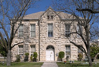
Val Verde County is a county located on the southern Edwards Plateau in the U.S. state of Texas. The 2014 population is 51,047. Its county seat is Del Rio. In 1936, Val Verde County received Recorded Texas Historic Landmark number 5625 to commemorate its founding.

The Nueces River is a river in the U.S. state of Texas, about 315 miles (507 km) long. It drains a region in central and southern Texas southeastward into the Gulf of Mexico. It is the southernmost major river in Texas northeast of the Rio Grande. Nueces is Spanish for nuts; early settlers named the river after the numerous pecan trees along its banks.
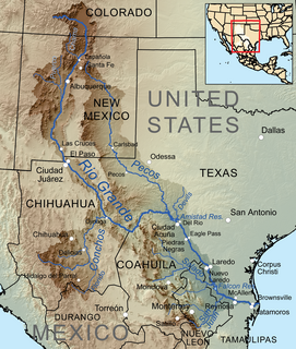
The Devils River in southwestern Texas, part of the Rio Grande drainage basin, has limited areas of whitewater along its length. It begins in northwest Sutton County, at 30°19′40″N100°56′31″W, where six watercourses come together, Dry Devils River, Granger Draw, House Draw, Jackson, Flat Rock Draw, and Rough Canyon. It flows southwest for 94 miles (151 km) through Val Verde County and empties into the northeastern shore of the Amistad Reservoir, an impoundment of the Rio Grande near Del Rio, Texas on the Texas/Mexico border, 29°27′33″N101°3′34″W. The discharge of the Devils River, as measured at IBWC gaging station 08-4494.00 near the river's mouth, averages 362 cubic feet per second (10.3 m3/s), with a maximum of 122,895 cubic feet per second (3,480 m3/s) and a minimum of 54 cubic feet per second (1.53 m3/s). Its drainage basin above that point is 10,259 square kilometres (3,961 sq mi).

The Middle Rio Grande Development Council (MRGDC) is a voluntary association of cities, counties and special districts in southern Texas.

Sycamore Canyon is the second largest canyon in the Arizona redrock country, after Oak Creek Canyon. The 21-mile (34 km) long scenic canyon reaches a maximum width of about 7 miles (11 km). It is in North Central Arizona bordering and below the Mogollon Rim, and is located west and northwest of Sedona in Yavapai and Coconino counties.

The Devils River minnow is a species of ray-finned fish in the family Cyprinidae. The minnow coexists with other closely related species and other cyprinids in the range of northern Mexico and southern Texas.

Lagoa Nova is a municipality of Rio Grande do Norte state in the Northeast of Brazil.
Sombrerillito Creek is a small stream of water located in Webb County, Texas which runs through Laredo, Texas. The creek is formed 13 miles north of Laredo and runs southwest for 16 miles until connecting to the Rio Grande. Sombrerillito Creek was dammed in northwest Laredo to form Sombrerillito Creek Lake, the third largest lake in Laredo. The terrain surrounding the creek is mostly clay and sandy loams. The vegetation surrounding the creek is mostly made up of mesquite, cacti, chaparral, hardwoods and grasses. Sombrerillito Creek crosses one major highway in Laredo, Texas among them are: Farm to Market Road 1472.
Howard Draw is a valley that heads in the extreme south of Reagan County, Texas at an elevation of 2720 feet at 30°05′09″N101°22′27″W, and runs through Crockett County to its foot on the Pecos River in Val Verde County, elevation 1575 feet.
Andreas is a village in the southeast corner of Schuylkill County, Pennsylvania, in West Penn Township on Route 895. A small part of Andreas is also in East Penn Township in Carbon County. The Lizard Creek flows eastward through the village to the Lehigh River. Andreas lies at the northern foot of Blue Mountain in ZIP code 18211.
See Elm Creek for the tributary of the Rio Grande, in Maverick County, Texas.
See Elm Creek for the tributary of the Nueces River, in Maverick County, Texas.
Turkey Creek, a tributary of the Nueces River with its source in Kinney County, Texas 29°14′32″N100°06′56″W. It passes through Uvalde and Dimmit Counties to its mouth at Espantosa Lake in Espantosa Slough south of Crystal City in Zavala County, Texas.
Evans Creek, a stream formerly a tributary of California Creek and Devils River it now flows into the western side of Amistad Reservoir at an elevation of 1119 feet. It has its source at 29°45′40″N101°10′06″W, at an elevation 1980 feet, near McNutt Summit.
Mud Creek, originally known as Maverick Creek, a stream in Kinney County, Texas tributary to Sycamore Creek and the Rio Grande. It has its source at 29°28′10″N100°36′24″W.
California Creek, formerly Painted Cave Spring Creek a stream in Val Verde County, Texas, formerly a tributary of Devils River it now flows into the north side of Amistad Reservoir at an elevation of 1119 feet. California Creek has its source at 29°37′29″N101°02′14″W.
San Pedro Creek, a stream in Val Verde County, Texas, formerly a tributary of Devils River. It is now flows into the east side of Amistad Reservoir at an elevation of 1135 feet. San Pedro Creek has its source at 29°33′34″N100°38′19″W.
Pecos Canyon, is a tributary of the Devils River in Val Verde County, Texas. It has its source at 30°16′17″N101°09′13″W, 8.6 miles north northwest of Juno, Texas.
Hudson Canyon, is a vally and a tributary ephemeral stream of the Devils River in Val Verde County, Texas. It has its source at 29°57′03″N101°10′38″W at an elevation of 1780 feet. Its mouth has its confluence with Devil's River a short distance below Bakers Crossing at 1499 feet.