Related Research Articles

Darling Harbour is a harbour adjacent to the city centre of Sydney, New South Wales, Australia that is made up of a large recreational and pedestrian precinct that is situated on western outskirts of the Sydney central business district.

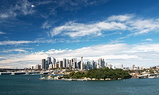
Port Jackson, consisting of the waters of Sydney Harbour, Middle Harbour, North Harbour and the Lane Cove and Parramatta Rivers, is the ria or natural harbour of Sydney, New South Wales, Australia. The harbour is an inlet of the Tasman Sea. It is the location of the Sydney Opera House and Sydney Harbour Bridge. The location of the first European settlement and colony on the Australian mainland, Port Jackson has continued to play a key role in the history and development of Sydney.

Circular Quay is a harbour, former working port and now international passenger shipping port, public piazza and tourism precinct, heritage area, and transport node located in Sydney, New South Wales, Australia on the northern edge of the Sydney central business district on Sydney Cove, between Bennelong Point and The Rocks. It is part of the local government area of the City of Sydney.

The Moruya River is an open and trained mature wave dominated barrier estuary or tidal river is located in the South Coast region of New South Wales, Australia. In its upper freshwater reaches, the river is known as the Deua River.
Goat Island is a heritage-listed island located in Port Jackson, in Sydney, New South Wales, Australia. Located northwest of the Sydney central business district, Goat Island is about 300m wide in a north/south direction and 180m long in an east/west direction; and covers an area of 5.4 hectares. Goat Island lies off the shores of the Sydney suburbs of Balmain and Millers Point, at the junction of Darling Harbour with the main channel of Sydney Harbour.

Sydney Heritage Fleet, is the trading name of Sydney Maritime Museum Ltd., a public company in Sydney, New South Wales, Australia.

Sydney Ferries is the public transport ferry network serving the city of Sydney, New South Wales. Services operate on Sydney Harbour and the connecting Parramatta River. The network is controlled by the New South Wales Government's transport authority, Transport for NSW, and is part of the authority's Opal ticketing system. In 2017–18, 15.3 million passenger journeys were made on the network.

Cahill Expressway is an urban freeway in Sydney and was the first freeway constructed in Australia, first opening to traffic in 1958. It links the southern foot of the Sydney Harbour Bridge, over an elevated roadway and through a series of sunken cuttings and tunnels between the Royal Botanic Garden and The Domain, to Woolloomooloo in Sydney's inner-eastern suburbs.

Barangaroo is an area of central Sydney, New South Wales, Australia. It is located on the north-western edge of the Sydney central business district and the southern end of the Sydney Harbour Bridge. It is part of the local government area of the City of Sydney. The area was used for fishing and hunting by Indigenous Australians prior to colonial settlement. The area is inclusive of The Hungry Mile, the name harbourside workers gave to the docklands area of Darling Harbour East during The Great Depression, where workers would walk from wharf to wharf in search of a job, often failing to find one.

The Finger Wharf is a heritage-listed former wharf and passenger terminal and now marina, residential apartments, hotel and restaurant located at 6 Cowper Wharf Road, in the inner city Sydney suburb of Woolloomooloo, Australia. It was designed by Henry D. Walsh and built from 1910 to 1915 by the Sydney Harbour Trust. It is also known as Woolloomooloo Finger Wharf and Woolloomooloo Wharf. The property is owned by Transport for NSW. The structure is the longest timbered-piled wharf in the world.

The SS South Steyne is a former Manly ferry on Sydney Harbour. She was the world's largest steam-powered passenger ferry and operated on the service from 1938 to 1974. Restored in the 1980s, she served as a restaurant ship in Newcastle in the 1990s, and in 2000 was moved back to Sydney and open to the public at Darling Harbour. Since April 2016 she has been stored at Berrys Bay. She was added to the New South Wales State Heritage Register on 2 April 1999.

Port Kembla is a man-made cargo port or artificial harbour, with an outer harbour protected by breakwaters and an inner harbour constructed by dredging, located in the Illawarra region of New South Wales, Australia.

The Overseas Passenger Terminal (OPT), known officially as the Sydney Cove Passenger Terminal, is a public passenger terminal servicing cruise ships and ocean liners located in Circular Quay, Sydney, Australia. Whilst commercial shipping operations on and around the site date from 1792, the current primary structure and waterfront promenade date from 1958, with subsequent on-going alterations and land reclamation throughout the latter part of the 20th century. The current design retains the black steel portal frame trusses of the original 1958 structure, with major additions completed in 1988 in the Post-War International Style through the collaboration of Sydney architects Lawrence Nield and Peter Tonkin.

Darling House is a heritage-listed seniors living property and former residence located at 8–12 Trinity Avenue, in the inner city Sydney suburb of Millers Point in the City of Sydney local government area of New South Wales, Australia. The property is owned by Dr Shane Moran through his luxury seniors living and aged care group Provectus Care Pty Ltd. It was added to the New South Wales State Heritage Register on 2 April 1999.
The coastal coal-carrying trade of New South Wales involved the shipping of coal—mainly for local consumption but also for export or coal bunkering—by sea to Sydney from the northern and southern coal fields of New South Wales. It took place in the 19th and 20th centuries. It should not be confused with the export coal trade, which still exists today. There was also an interstate trade, carrying coal and coke to other Australian states that did not have local sources of black coal.

The Walsh Bay Wharves Precinct, also known as the Walsh Bay Arts Precinct, is a heritage-listed former wharf precinct, now converted to hospitality and entertainment purposes, at Hickson Road, in the inner city Sydney suburb of Millers Point in the City of Sydney local government area of New South Wales, Australia. It was designed by H. D. Walsh, who also supervised its construction from 1912 to 1921. It includes the MSB Bond Store No. 3 and the Parbury Ruins. It was added to the New South Wales State Heritage Register on 2 April 1999.

The Millers Point & Dawes Point Village Precinct is a heritage-listed retail shops that support harbour functions, office and urban residences located at Upper Fort Street, in the inner city Sydney suburb of Millers Point and Dawes Point in the City of Sydney local government area of New South Wales, Australia. It was built from 1788 to. It is also known as Millers Point, Goodye, Leightons Point, Jack the Millers Point, 'Dawes Point, Tar-ra, Parish St Philip, Flagstaff Hill, Cockle Bay Point, the Point and Fort Street. It was added to the New South Wales State Heritage Register on 28 November 2003. The precinct was formerly home to industrial buildings and urban residences.

The Sussex Hotel is a heritage-listed hotel at 20 Sussex Street, Sydney, New South Wales, Australia. It was built from 1913 to 1915. Historically known as the New Hunter River Hotel, it was known as the Big House Hotel from 1973 until 1991, then as Napoleon's Hotel, Moreton's on Sussex and Moreton's Hotel before adopting its current name. It was added to the New South Wales State Heritage Register on 2 April 1999.
References
- ↑ History of the NSW Maritime Authority, NSW Maritime official website.
- ↑ Sydney Harbour Trust, State Records, New South Wales.
- ↑ "State Heritage Inventory, Playfair Street Terraces". www.hms.heritage.nsw.gov.au. Retrieved 28 December 2023.
- ↑ "ELECTRICAL SERVICE OF SYDNEY". Sydney Morning Herald . 6 August 1908. p. 7. Retrieved 29 December 2023.
- ↑ Charles Carey Lance (1859-1934) Retrieved 5 March 2019.
- ↑ MR. W. D. L0VERIDGE The Sydney Morning Herald, 8 January, 1940 p. 11. Retrieved 5 March 2019.
| Authority control databases: People |
|---|