Sydney Walton Square

Last updated
Sydney-G-Walton-Square-San-Francisco.jpg

Sydney Walton Square is a public park located just west of the Embarcadero in San Francisco, California, United States. The park is named after San Francisco banker Sydney Grant Walton. [1] [2]

Embarcadero (San Francisco) thoroughfare in San Francisco, United States

The Embarcadero is the eastern waterfront and roadway of the Port of San Francisco, San Francisco, California, along San Francisco Bay. It was constructed on reclaimed land along a three mile long engineered seawall, from which piers extend into the bay. It derives its name from the Spanish verb embarcar, meaning "to embark"; embarcadero itself means "the place to embark". The Central Embarcadero Piers Historic District was added to the National Register of Historic Places on November 20, 2002.

San Francisco Consolidated city-county in California, US

San Francisco, officially the City and County of San Francisco, is a city in, and the cultural, commercial, and financial center of, Northern California. San Francisco is the 13th-most populous city in the United States, and the fourth-most populous in California, with 883,305 residents as of 2018. It covers an area of about 46.89 square miles (121.4 km2), mostly at the north end of the San Francisco Peninsula in the San Francisco Bay Area, making it the second-most densely populated large US city, and the fifth-most densely populated U.S. county, behind only four of the five New York City boroughs. San Francisco is also part of the fifth-most populous primary statistical area in the United States, the San Jose–San Francisco–Oakland, CA Combined Statistical Area.

California State of the United States of America

California is a state in the Pacific Region of the United States. With 39.6 million residents, California is the most populous U.S. state and the third-largest by area. The state capital is Sacramento. The Greater Los Angeles Area and the San Francisco Bay Area are the nation's second- and fifth-most populous urban regions, with 18.7 million and 9.7 million residents respectively. Los Angeles is California's most populous city, and the country's second-most populous, after New York City. California also has the nation's most populous county, Los Angeles County, and its largest county by area, San Bernardino County. The City and County of San Francisco is both the country's second-most densely populated major city after New York City and the fifth-most densely populated county, behind only four of the five New York City boroughs.

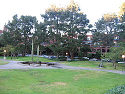
The 2-acre park was designed by Peter Walker. It was created as part of the city of San Francisco's partnership with Golden Gateway Center to bring more public art to the area. The park consists of public artwork by Jim Dine ( Big Heart on the Rock ), Marisol Escobar ( Portrait of Georgia O'Keeffe ), George Rickey ( Two Open Rectangles ), Joan Brown ( Pine Tree Obelisk ), Benny Bufano ( The Penguins ), and Francois Stahly ( Fountain of Four Seasons ). An old arch from the Colombo Market also resides in the park. It is the only remaining structure from San Francisco's historical produce district. [1] [2]

Public art is art in any media that has been planned and executed with the intention of being staged in the physical public domain, usually outside and accessible to all. Public art is significant within the art world, amongst curators, commissioning bodies and practitioners of public art, to whom it signifies a working practice of site specificity, community involvement and collaboration. Public art may include any art which is exhibited in a public space including publicly accessible buildings, but often it is not that simple. Rather, the relationship between the content and audience, what the art is saying and to whom, is just as important if not more important than its physical location.

Jim Dine American artist

Jim Dine is an American pop artist. He is sometimes considered to be a part of the Neo-Dada movement.

Marisol Escobar Venezuelan-American sculptor

Marisol Escobar, otherwise known simply as Marisol, was a French sculptor of Venezuelan heritage who worked in New York City.

Related Research Articles

Belmont, California City in California, United States

Belmont is a city in San Mateo County in the U.S. state of California. It is in the San Francisco Bay Area, on the San Francisco Peninsula halfway between San Francisco and San Jose. It was originally part of Rancho de las Pulgas, for which one of its main roads, the Alameda de las Pulgas, is named. The city was incorporated in 1926. Its population was 25,835 at the 2010 census.

San Mateo, California City in California, United States

San Mateo is a city in San Mateo County, California, approximately 20 miles (32 km) south of San Francisco, and 31 miles (50 km) northwest of San Jose. San Mateo had an estimated 2017 population of 104,748.

South San Francisco, California City in California in the United States

South San Francisco is a city in San Mateo County, California, United States, located on the San Francisco Peninsula in the San Francisco Bay Area. The population was 63,632 at the 2010 census.

Ocean Beach, San Francisco beach that runs adjacent to Golden Gate Park in San Francisco

Ocean Beach is a beach on the west coast of San Francisco, California, United States, bordering the Pacific Ocean. It is adjacent to Golden Gate Park, the Richmond District, and the Sunset District. The Great Highway runs alongside the beach, and the Cliff House and the site of the former Sutro Baths sit at the northern end. The beach is a part of the Golden Gate National Recreation Area, which is administered by the National Park Service.

Baker Beach beach on the peninsula of San Francisco, California, United States

Baker Beach is a public beach on the peninsula of San Francisco, California, U.S.. The beach lies on the shore of the Pacific Ocean in the northwest of the city. It is roughly a half mile long, beginning just south of Golden Gate Point, extending southward toward the Seacliff peninsula, the Palace of the Legion of Honor and the Sutro Baths. The northern section of Baker Beach is "frequented by clothing-optional sunbathers," and as such it is considered a nude beach.

Fine Arts Museums of San Francisco public arts institution in the city of San Francisco; comprises the de Young Museum in Golden Gate Park and the Legion of Honor in Lincoln Park

The Fine Arts Museums of San Francisco, comprising the de Young Museum in Golden Gate Park and the Legion of Honor in Lincoln Park, is the largest public arts institution in the city of San Francisco. The permanent collection of the Fine Arts Museums, with about 150,000 objects, is organized into nine areas, each with a curatorial staff.

Fort Baker historic military facility in San Francisco

Fort Baker is one of the components of California's Golden Gate National Recreation Area. The Fort, which borders the City of Sausalito in Marin County and is connected to San Francisco by the Golden Gate Bridge, served as an Army post until the mid-1990s, when the headquarters of the 91st Division moved to Parks Reserve Forces Training Area. It is located opposite Fort Point at the entrance to the San Francisco Bay.

Middle Harbor Shoreline Park public park in Oakland, California, USA

Middle Harbor Shoreline Park (MHSP) is located on San Francisco Bay and the Port of Oakland entrance channel, west of downtown Oakland, California. It is owned and operated by the Port of Oakland. The park entrance is at the intersection of 7th and Middle Harbor Streets. It is open seven days a week from 8 a.m. to dusk.

Hayward Regional Shoreline

Hayward Regional Shoreline is a regional park located on the shores of the San Francisco Bay in Hayward, California. It is part of the East Bay Regional Parks system. The 1,713 acre park extends to the shores of San Lorenzo. Part of the park is former commercial salt flats purchased in 1996. A former landfill, now capped with soil and plants, is located in the park. The park includes the 250 acre tidal wetland, Cogswell Marsh, and the 364 acre Oro Loma Marsh. Located to the south of the park is the Hayward Shoreline Interpretive Center, which provides information on the Bay shore habitats. The San Francisco Bay Trail runs through the park, which connects the park with San Lorenzo Creek.

Parkside, San Francisco human settlement in San Francisco, California, United States of America

The Parkside is a affluent neighborhood in the western part of San Francisco, California. It is located in the southern part of the Avenues south of Quintara and north of Sloat Boulevard. The neighborhood has the unique distinction of more parks per capita than any other neighborhood in San Francisco. They include: Parkside Square, Pine Lake, Pine Lake Park, Concert Meadow, Charlie Sava Pool, Carl Larsen Park, Stern Grove, McCoppin Park, and McCoppin Square.

Garfield Square

Garfield Square, also known as Garfield Park, is a 3.46-acre (14,000 m2) city park located in the Mission District of San Francisco, California. It is bounded by 25th Street to the north, 26th Street to the south, Treat Avenue to the west, and Harrison Street to the east and was first opened in 1884. Previously the location of the Recreation Grounds baseball park which was the first professional baseball park in California, dating to 1868.

Recreation Park (San Francisco) name of several former baseball parks in San Francisco

Recreation Park was the name applied to several former baseball parks in San Francisco, California in the late 19th Century and early 20th Century.

Año Nuevo State Marine Conservation Area

Año Nuevo State Marine Conservation Area (SMCA) is one of two adjoining marine protected areas off the coast of San Mateo and Santa Cruz Counties, on California’s central coast.The area is approximately 55 miles south of San Francisco. The SMCA is 11.07 square miles. Except for limited taking of giant kelp, all living marine resources are protected.

TechShop

TechShop was a chain of membership-based, open-access, do-it-yourself (DIY) workshops and fabrication studios. As of 2017 they had ten locations in the United States: three in California, one in Arizona, one in Arlington, Virginia, one in Michigan, one in Texas, one in Pittsburgh, Pennsylvania, and one in Brooklyn, New York, as well as four international locations.

Pink Triangle Park

The Pink Triangle Park is a triangular shaped mini-park located in the Castro District of San Francisco, California. The park is less than 4,000 square feet and faces Market Street with 17th Street to its back. The park sits directly above the Castro Street Station of Muni Metro, across from Harvey Milk Plaza. It is the first permanent, free-standing memorial in America dedicated to the thousands of persecuted homosexuals in Nazi Germany during the Holocaust of World War II.

Peninsula Library System Consortium of Libraries

The Peninsula Library System (PLS) is a consortium of public and community college libraries in San Mateo County, California, United States, which serves the part of the San Francisco Bay Area known as "The Peninsula". The system has dozens of branches in local communities and at various area community colleges, a bookmobile, and automated book kiosks called Library-a-Go-Go.

Pioneer Monument (San Francisco) monument in San Francisco, dedicated in 1894

The Pioneer Monument is a granite monument supporting bronze figures and bas reliefs created by Frank Happersberger and financed by the estate of James Lick. It is located on Fulton Street between Hyde and Larkin Streets in the Civic Center, of San Francisco, California. It was dedicated on November 29, 1894.

Jackson Street (San Francisco) street in San Francisco

Jackson Street is a street in San Francisco, California, running through the Pacific Heights, Nob Hill, Chinatown and Jackson Square districts of the city. It runs between Pacific Avenue and Washington Street, beginning at Arguello Boulevard to the south of the Presidio Golf Course and ending at Drumm Street, to the west of Pier 3, near Sydney G. Walton Square.

Saint Marys Square park in the United States of America

Saint Mary's Square is a park and urban square in San Francisco's Chinatown, in the U.S. state of California. It features a statue of Dr. Sun Yat-sen by Beniamino Bufano.

References

  1. 1 2 Todd, Gail (18 September 2008). "Sydney G. Walton Square sculpture stroll". SF Gate. Retrieved 12 May 2012.
  2. 1 2 Luthi, Jessica (21 March 2009). "The Polaroid Chronicles, Part Four". The Guardsman. Retrieved 12 May 2012.

Coordinates: 37°47′51″N122°23′56″W / 37.79751°N 122.39902°W / 37.79751; -122.39902

Geographic coordinate system Coordinate system

A geographic coordinate system is a coordinate system that enables every location on Earth to be specified by a set of numbers, letters or symbols. The coordinates are often chosen such that one of the numbers represents a vertical position and two or three of the numbers represent a horizontal position; alternatively, a geographic position may be expressed in a combined three-dimensional Cartesian vector. A common choice of coordinates is latitude, longitude and elevation. To specify a location on a plane requires a map projection.