Souli is a village and a community in the municipality of Megalopoli in southwestern Arcadia, Greece. The community consists of the mountain villages Souli and Derveni. Both villages are located in the mountains on the border with Messenia, at about 500 m elevation. Derveni is on the old road from Megalopoli to Kalamata, and Souli is 1 km southeast of it. Souli is 2 km west of Chirades, 4 km southwest of Paradeisia, 15 km southwest of Megalopoli and 30 km north of Kalamata. Souli suffered damage from the 2007 Greek forest fires.
Kallithea is a community in the suburbs of Patras in Achaea, Greece. It is located 9 km south of downtown Patras, on the Greek National Road 33 to Tripoli. The community consists of the villages Kallithea and Ano Kallithea, and is part of the municipal unit Messatida within the municipality of Patras. The nearest villages are Ovrya to the north and Thea to the west. To the east lies the mountain Omplos.
Perivolia is a village and a community in the southwestern part of Arcadia, Greece. It is part of the municipality of Megalopoli, located in a rural area 3 km (2 mi) south-east of downtown Megalopoli. The Greek National Road 7/E55 (Corinth - Tripoli - Kalamata passes southeast of the village. The community consists of the villages Perivolia and Vrysoules.
Varvasaina is a village and a community in the eastern part of the municipality of Pyrgos, Elis, Greece. The community consists of the villages Varvasaina and Kato Varvasaina. It is situated in a valley between low hills, 3 km southeast of Koliri, 3 km northwest of Salmoni, 5 km north of Epitalio and 5 km east of Pyrgos town centre. The Greek National Road 74 passes south of the village. The railway from Pyrgos to Kalamata and Olympia passes through Kato Varvasaina.
Kentro is a village and a community of the Ilida municipality. Before the 2011 local government reform it was a part of the municipality of Amaliada, of which it was a municipal district.
Heraklion is one of the four regional units of Crete. The capital is the city of Heraklion.

Gazi is a Western suburb of Heraklion and a former municipality in the Heraklion regional unit of Crete in Greece. Since the 2011 local government reform, it has been part of the municipality Malevizi, of which it is a municipal unit. It lies 6 kilometres west of Heraklion, on the north coast of Crete. With 16,256 inhabitants, it was the seat of the municipality of Gazi, which comprised several nearby villages with a total population of 20,918 and an area of 95.81 square kilometres (36.99 sq mi).

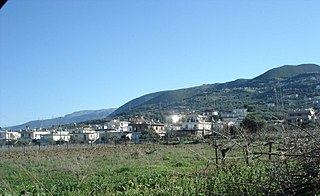
Viannos is a municipality in the Heraklion regional unit, Crete, Greece. The municipality has an area of 221.539 km2 (85.537 sq mi). Population 4,436 (2021). The seat of the municipality is in Ano Viannos.
Agios Dimitrios is a former municipality in the Ioannina regional unit, Epirus, Greece. Since the 2011 local government reform it is part of the municipality Dodoni, of which it is a municipal unit. Population 3,277 (2021), its area is 231.473 km². The seat of the municipality was in Theriakisi. The largest village is Kato Mousiotitsa which has a school, gymnasium and lyceum. The municipal unit covers the northwestern part of the Xerovouni mountains.
Tsagkarada is a village and a community in the municipal unit of Mouresi in the eastern part of Magnesia, Greece.
Kallithea Elassonos, known before 1927 as Sadovo, is a village and a community of the Elassona municipality. Before the 2011 local government reform it was a part of the municipality of Olympos. The community of Kallithea Elassonos covers an area of 30.437 km2.
Chalkiades is a village in the south of the Larissa regional unit, Greece. It is part of the municipal unit of Polydamantas. Chalkiades is located in the Thessalian Plain, 12 km north of Farsala and 27 km south of Larissa. The Greek National Road 3 passes through the village.

Drakotrypa is a mountain village and a community in the municipality of Mouzaki, in the western part of the Karditsa regional unit, Greece. The community consists of the villages Drakotrypa, Arpakia, Keramargio, Milies, Spathes, Trygona and Tsarouchi. Drakotrypa is located at the foot of the Pindus mountains, 6 km southwest of Mouzaki and 28 km west of Karditsa.
Agios Stefanos is a village and a community in the municipality West Achaea, Greece. It is located on both sides of the river Tytheus, 17 km southwest of Patras. The community includes the villages Palaia Peristera and Fylakes. Agios Stefanos is part of the municipal unit of Olenia.

Chondros is a village and a community in the Heraklion regional unit of the island of Crete, Greece. It is part of the municipality Viannos. The community consists of the villages Chondros, Agios Ioannis, Dermatos, Kastri and Pervola.
Kato Symi is a small historic village of Crete, in Heraklion regional unit, 31 km (19 mi) from Ierapetra and 74 km (46 mi) from Heraklion city. Today it belongs to Viannos municipality and borders the Ierapetra municipality. It lies about 780 m (2,560 ft) above sea level, south of Mount Dikti in a verdant mountainous area, which is probably the most wooded of Crete. Near the village, at an altitude of 1,200 m (3,900 ft), lies the ancient sanctuary of Hermes and Aphrodite. It is dated from the middle Minoan period and had been used for worship for more than 1,000 years. Kato Simi has been destroyed three times, by Arabs, Turks and finally by the German army in World War II, when it was the center of resistance of the Viannos–Ierapetra area against the Nazi occupying forces.
Argyropouli is an Aromanian (Vlach) village and a community of the Tyrnavos municipality. The community of Argyropouli covers an area of 103.063 km2.

Moschopotamos is a village and a community of the Katerini municipality. Before the 2011 local government reform it was part of the municipality of Elafina, of which it was a municipal district. The community of Moschopotamos covers an area of 13,606 km (8,454 mi).

Polydrosos is a village and a community of the Delphi municipality. Before the 2011 local government reform it was a part of the municipality of Parnassos, of which it was a municipal district. The community of Polydrosos covers an area of 38.672 km2.
Molykreio is a village and a community in Nafpaktia, Aetolia-Acarnania, Greece. The community includes the villages Ano Platanitis, Fragkaiika and Platanitis.


