
Camillus is a town in Onondaga County, New York, United States. As of the 2020 Census, the population was 25,346.

Frederick Douglass Greater Rochester International Airport is a public airport located within the City of Rochester, three miles (4.8 km) southwest of Downtown, in Monroe County, New York, United States. It is owned and operated by Monroe County. The airport is home to the 642nd Aviation Support Battalion, part of the 42nd Infantry Division.
Charles George Hanna (1889–1942) was a politician from the United States. He was the forty-first mayor of Syracuse, New York and largely responsible for bringing air travel to the Syracuse Area. He acquired an airfield in Camillus, New York and renamed it Syracuse Municipal Airport in 1927. After World War II, the airport couldn't keep up with demand, so the city took over the former Mattydale Bomber Base and renamed it Syracuse Hancock International Airport.

Roosevelt Field is a former airport, located in Westbury, Long Island, New York. Originally called the Hempstead Plains Aerodrome, or sometimes Hempstead Plains field or the Garden City Aerodrome, it was a training field for the Air Service, United States Army during World War I.
Santa Maria Public Airport is three miles (5 km) south of Santa Maria, in northern Santa Barbara County, California, United States.

Falcon Field is in an airport located in Maricopa County, Arizona. It was originally built 6 miles northeast of Mesa, which owns it. However, it is now within city limits. The National Plan of Integrated Airport Systems for 2017–2021 categorized it as a reliever airport. Scheduled service to Bullhead City on Western Express Air ended in January 2007.
New York State Route 173 (NY 173) is a state highway located in the Syracuse area of central New York in the United States. It takes a slightly bow-shaped route from NY 31 in the town of Van Buren to NY 5 in Chittenango, gently curving to the south of Downtown Syracuse in the center of its 30.59-mile (49.23 km) routing. Even so, NY 173 briefly enters the Syracuse city limits near where it intersects U.S. Route 11 (US 11). NY 173 passes through several suburbs of Syracuse, including Camillus, where it first meets NY 5, and Manlius, where it has a short overlap with NY 92.

Bartow Executive Airport is a public airport four miles (6 km) northeast of Bartow, in Polk County, Florida. It is owned by the Bartow Airport Authority.

Hawkins Field is a joint civil-military public airport in Jackson, Mississippi. It is owned by the City of Jackson and operated by the Jackson Municipal Airport Authority. The National Plan of Integrated Airport Systems for 2011–2015 called it a general aviation facility.

Daniel Field is a public use airport located one nautical mile (2 km) west of the central business district of Augusta, a city in Richmond County, Georgia, United States. It is owned by the City of Augusta and operated by the General Aviation Commission. This airport is included in the National Plan of Integrated Airport Systems for 2021–2025, which categorized it as a general aviation facility.

Pecos Municipal Airport is a city-owned airport two miles southwest of Pecos, in Reeves County, Texas, United States. The FAA's National Plan of Integrated Airport Systems for 2009–2013 categorized it as a general aviation airport.

Avon Park Executive Airport is a city-owned, public-use airport located two nautical miles (3.7 km) west of the central business district of Avon Park, a city in Highlands County, Florida, United States.

Imeson Field, also known as Jacksonville Imeson Airport, was the airport serving Jacksonville, Florida, from 1927 until its closing in 1968. It was known as Jacksonville Municipal Airport prior to World War II, Jacksonville Army Airfield when the United States Army Air Forces controlled the facility during World War II, and at its closing the airport was Jacksonville – Thomas Cole Imeson Municipal Airport.
Echeverria Field is an abandoned airfield, located approximately 15 miles (24 km) west of Wickenburg, Arizona.

Thompson–Robbins Airport is 6 miles (9.7 km) northwest of the center of Helena–West Helena, in unincorporated Phillips County, Arkansas, United States. It is owned by the city of Helena–West Helena.

Hancock Field is a former airport and military airfield about 2 miles (3.2 km) south-southeast of Santa Maria, California. Also known as Santa Maria Municipal Airport, the airport was closed about 1959 and today is the site of Allan Hancock College.

Bruce Field is a city-owned public-use general aviation airport located five nautical miles southwest of the central business district of Ballinger, a city in Runnels County, Texas, United States.

Arledge Field is a public general aviation airport located approximately 4 miles (6.4 km) east of Stamford, Texas. Owned by the city of Stamford, it provides general aviation service. Approximately 80 aircraft use the airport on a weekly basis.

Hancock Field Air National Guard Base is a United States Air Force base, co-located with Syracuse Hancock International Airport. It is located 4.6 miles (7.4 km) north-northeast of Syracuse, New York, at 6001 East Molloy Road in Mattydale. The installation consists of approximately 350 acres (1.4 km2) of flight line, aircraft ramp and support facilities on the south side of the airport.

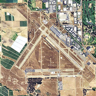
Syracuse Hancock International Airport is a joint civil–military airport five miles (8 km) northeast of downtown Syracuse, New York. Operated by the Syracuse Regional Airport Authority, it is located off Interstate 81, near Mattydale. The main terminal complex is at the east end of Colonel Eileen Collins Boulevard. Half of the airport is located within the Town of DeWitt, with portions within the adjacent towns of Salina and Cicero.


