
Świdnica County is a unit of territorial administration and local government (powiat) in Lower Silesian Voivodeship, south-western Poland. It came into being on January 1, 1999, as a result of the Polish local government reforms passed in 1998. The county covers an area of 742.9 square kilometres (286.8 sq mi). Its administrative seat is Świdnica, and it also contains the towns of Świebodzice, Strzegom, Jaworzyna Śląska and Żarów.
Ciply is a village near the Belgian town of Mons in the province of Hainaut.

Highway 13 is an expressway in southern Israel. It is 12 km long. It begins in the north at Tzihor junction with Highway 40, and ends in the south at Menuha junction with Highway 90. Thus, it connects between Highway 40, which runs north to Mizpe Ramon and Beersheba via the central Negev, and Highway 90, which traverses the Arava region on Israel's eastern border.

Podole is a village in the administrative district of Gmina Rypin, within Rypin County, Kuyavian-Pomeranian Voivodeship, in north-central Poland. It lies approximately 5 kilometres (3 mi) north of Rypin and 55 km (34 mi) east of Toruń.
Gawin is a village in the administrative district of Gmina Chodecz, within Włocławek County, Kuyavian-Pomeranian Voivodeship, in north-central Poland.
Słok-Młyn is a settlement in the administrative district of Gmina Kleszczów, within Bełchatów County, Łódź Voivodeship, in central Poland. It lies approximately 9 kilometres (6 mi) north of Kleszczów, 9 km (6 mi) south of Bełchatów, and 56 km (35 mi) south of the regional capital Łódź.
Pardasówka is part of Sabaudia village in the administrative district of Gmina Tomaszów Lubelski, within Tomaszów Lubelski County, Lublin Voivodeship, in eastern Poland.
Sielec-Kolonia is a village in the administrative district of Gmina Skalbmierz, within Kazimierza County, Świętokrzyskie Voivodeship, in south-central Poland. It lies approximately 1 kilometre (1 mi) north-east of Skalbmierz, 9 km (6 mi) north-west of Kazimierza Wielka, and 62 km (39 mi) south of the regional capital Kielce.

Posuchy is a village in the administrative district of Gmina Raniżów, within Kolbuszowa County, Subcarpathian Voivodeship, in south-eastern Poland. It lies approximately 5 kilometres (3 mi) north-east of Raniżów, 20 km (12 mi) east of Kolbuszowa, and 29 km (18 mi) north of the regional capital Rzeszów.
Dąbrowica is a village in the administrative district of Gmina Kuryłówka, within Leżajsk County, Subcarpathian Voivodeship, in south-eastern Poland. It lies approximately 7 kilometres (4 mi) east of Kuryłówka, 10 km (6 mi) east of Leżajsk, and 49 km (30 mi) north-east of the regional capital Rzeszów.
Podlesie is a village in the administrative district of Gmina Bogoria, within Staszów County, Świętokrzyskie Voivodeship, in south-central Poland. It lies approximately 3 kilometres (2 mi) south-east of Bogoria, 13 km (8 mi) north-east of Staszów, and 55 km (34 mi) south-east of the regional capital Kielce.
Niwa is a village in the administrative district of Gmina Dzierzążnia, within Płońsk County, Masovian Voivodeship, in east-central Poland.
Przemkowo is a village in the administrative district of Gmina Dzierzążnia, within Płońsk County, Masovian Voivodeship, in east-central Poland. It lies approximately 7 kilometres (4 mi) south-east of Dzierzążnia, 9 km (6 mi) south-west of Płońsk, and 64 km (40 mi) north-west of Warsaw.
Brochów-Kolonia is a village in the administrative district of Gmina Brochów, within Sochaczew County, Masovian Voivodeship, in east-central Poland.
Bielawy is a village in the administrative district of Gmina Strzałkowo, within Słupca County, Greater Poland Voivodeship, in west-central Poland.
Smolniki is a settlement in the administrative district of Gmina Trzciel, within Międzyrzecz County, Lubusz Voivodeship, in western Poland. It lies approximately 9 kilometres (6 mi) south of Trzciel, 26 km (16 mi) south-east of Międzyrzecz, 46 km (29 mi) north-east of Zielona Góra, and 65 km (40 mi) south-east of Gorzów Wielkopolski.

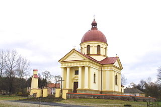
Újezdec is a village and municipality in Mělník District in the Central Bohemian Region of the Czech Republic. The municipality covers an area of 2.36 square kilometres (0.91 sq mi) and as of 2006 it had a population of 94. First written notice about the village is from year 1380.
Všestudy is a village and municipality in Mělník District in the Central Bohemian Region of the Czech Republic.

Holubice is a village and municipality in Prague-West District in the Central Bohemian Region of the Czech Republic.
Gangara, Niger is a village and rural commune in Niger.


