
In the United States, a county or county equivalent is an administrative or political subdivision of a U.S. state or other territories of the United States which consists of a geographic area with specific boundaries and usually some level of governmental authority. The term "county" is used in 48 states, while Louisiana and Alaska have functionally equivalent subdivisions called parishes and boroughs, respectively. The specific governmental powers of counties vary widely between the states, with many providing some level of services to civil townships, municipalities, and unincorporated areas. Certain municipalities are in multiple counties; New York City is uniquely partitioned into five counties, referred to at the city government level as boroughs. Some municipalities have been consolidated with their county government to form consolidated city-counties, or have been legally separated from counties altogether to form independent cities. Conversely, counties in Connecticut, Rhode Island, eight of Massachusetts's 14 counties, and Alaska's Unorganized Borough have no government power, existing only as geographic distinctions.

The London Borough of Hackney is a London borough in Inner London, England. The historical and administrative heart of Hackney is Mare Street, which lies 5 miles (8 km) north-east of Charing Cross. The borough is named after Hackney, its principal district. Southern and eastern parts of the borough are popularly regarded as being part of east London that spans some of the traditional East End of London with the northwest belonging to north London. Its population is estimated to be 281,120.

The London Borough of Barking and Dagenham is a London borough in East London. It lies around 9 miles (14.4 km) east of Central London. The borough was created in 1965 as the London Borough of Barking; the name was changed in 1980. It is an Outer London borough and the south is within the London Riverside section of the Thames Gateway; an area designated as a national priority for urban regeneration. At the 2011 census it had a population of 187,000. The borough's three main towns are Barking, Chadwell Heath and Dagenham. The local authority is the Barking and Dagenham London Borough Council. Barking and Dagenham was one of six London boroughs to host the 2012 Summer Olympics.

Kirklees is a metropolitan borough of West Yorkshire, England. The borough comprises the ten towns of Batley, Birstall, Cleckheaton, Dewsbury, Heckmondwike, Holmfirth, Huddersfield, Meltham, Mirfield and Slaithwaite. It is governed by Kirklees Council. Kirklees had a population of 422,500 in 2011; it is the third-largest metropolitan district in England by area, behind Doncaster and Leeds.

Telford and Wrekin is a borough and unitary authority in Shropshire, England. In 1974, a non-metropolitan district of Shropshire was created called the Wrekin, named after a prominent hill to the west of Telford. In 1998, the district became a unitary authority and was renamed "Telford and Wrekin", which remains part of the Shropshire ceremonial county and shares institutions such as the Fire and Rescue Service and Community Health with the rest the county.

A municipality is the smallest administrative subdivision of Estonia. Each municipality is a unit of self-government with its representative and executive bodies. The municipalities in Estonia cover the entire territory of the country.

Charnwood is a local government district with borough status in the north of Leicestershire, England. It is named after Charnwood Forest, much of which lies within the borough. Towns in the borough include Loughborough, Shepshed and Syston. Villages in the borough include Barrow upon Soar, Birstall, Hathern, Mountsorrel, Quorn, Rothley, Sileby and Woodhouse Eaves.
The Borough of Swindon is a unitary authority area with borough status in Wiltshire, England. Centred on Swindon, it is the most north-easterly district of South West England.

Barking is a riverside town in East London, England, within the London Borough of Barking and Dagenham. It is 9.3 miles (15 km) east of Charing Cross. The total population of Barking was 59,068 at the 2011 census. In addition to an extensive and fairly low-density residential area, the town centre forms a large retail and commercial district, currently a focus for regeneration. The former industrial lands to the south are being redeveloped as Barking Riverside.
The Borough of Eastleigh is a local government district with borough status in Hampshire, England. It is named after its main town of Eastleigh, where the council is based. The borough also contains the town of Hedge End along with several villages, many of which form part of the South Hampshire urban area.

The City of Colchester is a local government district with city status in Essex, England, named after its main settlement, Colchester. The district also includes the towns of West Mersea and Wivenhoe and the surrounding rural areas stretching from Dedham Vale on the Suffolk border in the north to Mersea Island in the Colne Estuary in the south.

The Borough of Hartlepool is a local government district with borough status in County Durham, England. Since 1996 Hartlepool Borough Council has been a unitary authority, being a district council which also performs the functions of a county council; it is independent from Durham County Council. It is named after its largest settlement, Hartlepool, where the council is based. The borough also includes a rural area to the west of the town. The population of the borough at the 2021 census was 92,571, of which over 95% (87,995) lived in the built-up area of Hartlepool itself.

Kaarma Parish was a municipality of Saare County, Estonia next to Kuressaare. In 2014, it was merged with the municipalities of Kärla and Lümanda to become the Lääne-Saare municipality.

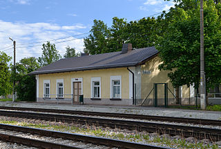
Tapa Parish is a rural municipality in Lääne-Viru County in northern Estonia.
Tamsalu is a town in Tapa Parish, Lääne-Viru County, Estonia.

Tamsalu Parish was a rural municipality of Estonia, in Lääne-Viru County. It had a population of 3,726 and an area of 214.61 km2.
Saiakopli is a village in Tapa Parish, Lääne-Viru County, in northeastern Estonia. It's located about 7.5 km (5 mi) southeast of the town of Tapa and about 7 km (4 mi) northwest of Tamsalu. Saiakopli is bordered by the Tallinn–Tapa–Tartu railway to the southwest and by the Valgejõgi River to the northwest.
Suur-Randvere is a village in Saaremaa Parish, Saare County in western Estonia.

Salme is a small borough in Saaremaa Parish, Saare County, in western Estonia. Prior to the administrative reform of Estonian municipalities in 2017, the village was the administrative center of Salme Parish.
Lääne-Saare Parish was a rural municipality of Estonia, in Saare County. It was located on the western part of Saaremaa island. The municipality has a population of ca 7,200 and an area of 807 km2.
