The Jubilee line is a London Underground line that runs between Stratford in east London and Stanmore in the suburban north-west, via the Docklands, South Bank and West End. Opened in 1979, it is the newest line on the network, although some sections of track date back to 1932 and some stations to 1879.

The Piccadilly line is a London Underground line that runs between Cockfosters in suburban north London and Acton Town in the west, where it divides into two branches: one of these runs to Heathrow Airport and the other to Uxbridge in northwest London, with some services terminating at Rayners Lane.

Kassel is one of the three Regierungsbezirke of Hesse, Germany, located in the north of the state. It was created in 1866 when Prussia annexed the area to form the new province Hesse-Nassau. Altogether it consists of 138 municipalities.

Sömmerda is a Kreis (district) in the north of Thuringia, Germany. Neighboring districts are the districts Kyffhäuserkreis, the Burgenlandkreis in Saxony-Anhalt, the district Weimarer Land and the district-free city Erfurt, and the districts Gotha and Unstrut-Hainich.
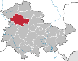
Unstrut-Hainich-Kreis is a Kreis (district) in the north of Thuringia, Germany. Neighboring districts are the districts Eichsfeld, Kyffhäuserkreis, Sömmerda, Gotha, Wartburgkreis and the district Werra-Meißner in Hesse.
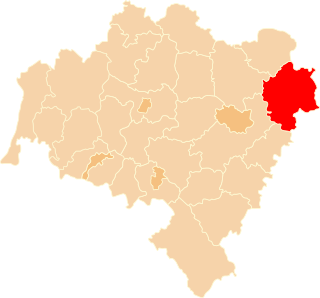
Trzebnica County is a unit of territorial administration and local government (powiat) in Lower Silesian Voivodeship, south-western Poland. It came into being on January 1, 1999, as a result of the Polish local government reforms passed in 1998. The county covers an area of 1,025.5 square kilometres (395.9 sq mi). Its administrative seat is Trzebnica, and it also contains the towns of Oborniki Śląskie, Żmigród and Prusice.

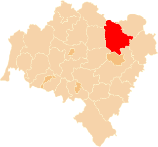
Wrocław County is a unit of territorial administration and local government (powiat) in Lower Silesian Voivodeship, south-western Poland. It came into being on January 1, 1999, as a result of the Polish local government reforms passed in 1998. The county covers an area of 1,116 square kilometres (431 sq mi). Its administrative seat is the city of Wrocław, although this city is not part of the county. Wrocław County consists of areas to the east and south of Wrocław, and contains three towns: Sobótka, Kąty Wrocławskie and Siechnice.
Shuswap Lake Marine Provincial Park is an 896-hectare provincial park in British Columbia, Canada, comprising 991 ha. The Park has a variety of amenities including boat launch ramps, picnic areas, and 27 campsites around the perimeter of Shuswap Lake. The lake's name and that of the surrounding Shuswap Country is from the Shuswap people (Secwepemc), the most northern of the Salishan speaking people.
Sulmierzyce is a town in Krotoszyn County, Greater Poland Voivodeship, Poland, located southeast of Poznań, at 51°36′N17°32′E.

Advanced Landing Grounds (ALGs) were temporary advance airfields constructed by the Allies during World War II during the liberation of Europe. They were built in the UK prior to the invasion and thereafter in northwest Europe from 6 June 1944 to V-E Day, 7 May 1945.

The River Teise is a tributary of the River Medway in Kent, England. It begins in Dunorlan Park in Tunbridge Wells. and flows eastwards past Bayham Abbey and then through Lamberhurst. 2 miles downstream of Lamberhurst the small River Bewl, on which is the reservoir Bewl Water, joins the Teise.

Kehidakustány is a village in Zala County, Hungary.
Padár is a village in Zala County, Hungary.
Vállus is a village in Zala County, Hungary.
Zalaköveskút is a village in Zala County, Hungary.
Rumah District is a district of the Mahrah Governorate, Yemen. As of 2003, the district had a population of 6,357 inhabitants.
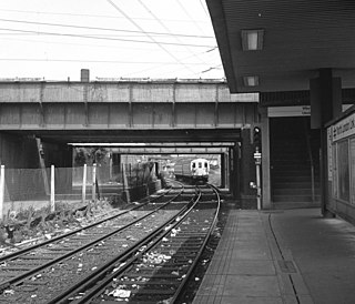
The West Ham station attack was a bomb and shooting incident at West Ham station in east London on 15 March 1976. A 5 lb bomb on a Metropolitan line train exploded prematurely in the front carriage of the train, injuring seven passengers. The bomb detonated prior to reaching the City of London, where it was thought the intended target was Liverpool Street station at rush hour. The suspect, Adrian Vincent Donnelly, a Provisional Irish Republican Army (IRA) terrorist, then shot Peter Chalk, a Post Office engineer, in the chest. He then shot and killed the train's driver Julius Stephen, who had attempted to catch him. Donelly exited the station to the street and threatened people with his revolver before PC Raymond Kiff caught up with him. Shouting "You English bastards!", Donelly shot himself in the chest, but he survived and was apprehended by Kiff.