2069 Hubble, provisional designation 1955 FT, is a carbonaceous asteroid from the outer region of the asteroid belt, approximately 40 kilometers in diameter. It was discovered on 29 March 1955, by the Indiana Asteroid Program at Goethe Link Observatory, United States, and named after American astronomer Edwin Hubble.
Greater Oslo Region is a statistical metropolitan region surrounding the Norwegian capital of Oslo. The region includes the city of Oslo, the entire county of Akershus and several municipalities in the counties of Buskerud (150,709), Oppland (8,552), Vestfold (27,695) and Østfold (102,808).

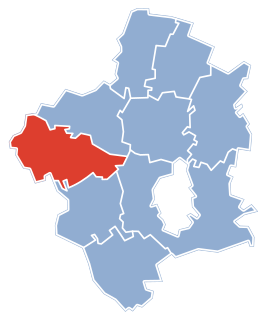
Topoľčany District is a district in the Nitra Region of western Slovakia. It borders Nové Mesto nad Váhom District and Bánovce nad Bebravou District in the north, Piešťany District and Hlohovec District in the west, Partizánske District in the east and Nitra District and Zlaté Moravce District in the south. The district in its present form was established in 1996, before that date Topoľčany district had been composed of two present districts, Topoľčany District and Partizánske District.
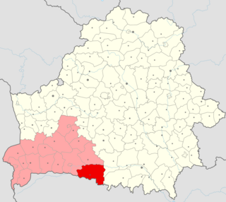
Stolin District or Stolinski Rayon is district (raion) in the southeast of the Brest Region, Belarus. Its administrative center is in the city of Stolin. The region has a population of 89,000 people, of which 26,300 people live in urban areas.

Drienovská Nová Ves is a village and municipality in Prešov District in the Prešov Region of eastern Slovakia.

Olcsva is a village in Szabolcs-Szatmár-Bereg county, in the Northern Great Plain region of eastern Hungary.
HAT-P-6 is a star in the constellation Andromeda, located approximately 910 light years or 280 parsecs away from the Earth. It is an F-type star, implying that it is hotter and more massive than our Sun. The apparent magnitude of the star is +10.54, which means that it can only be visible through the telescope. The absolute magnitude of +4.03 is brighter than the Sun's +4.83, meaning that the star itself is brighter than the Sun. A search for a binary companion star using adaptive optics at the MMT Observatory turned out negative.

Peabody–Darst–Webbe is a neighborhood of St. Louis, Missouri. It is also called the Near Southside neighborhood. Peabody–Darst–Webbe is an area bounded by S. Tucker Blvd. on the east, Chouteau Ave. on the north, Dolman Street on the west, and the I-55/I-44 interchange on the south.
A695 road is a road in Northern England linking Newcastle upon Tyne, Tyne and Wear, with Hexham, Northumberland. It was part of the proposed A695(M) Shields Road Motorway.
Wasa Station is a railway station in Hidakagawa, Hidaka District, Wakayama Prefecture, Japan.
Linby railway station was a station on what is now the Robin Hood Line. It was used predominantly to serve Linby Colliery. It shut in 1964. When the line was re-opened in the 1990s it was decided not to re-open Linby station, or the nearby Annesley railway station.

Kończewo is a village in the administrative district of Gmina Kobylnica, within Słupsk County, Pomeranian Voivodeship, in northern Poland. It lies approximately 7 kilometres (4 mi) south of Kobylnica, 11 km (7 mi) south-west of Słupsk, and 109 km (68 mi) west of the regional capital Gdańsk.
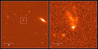
GRB 990123 is a gamma-ray burst which was detected on January 23, 1999. It was the first GRB for which a simultaneous optical flash was detected. Astronomers first managed to obtain a visible-light image of a GRB as it occurred on January 23, 1999, using the ROTSE-I telescope in Los Alamos, New Mexico. The ROTSE-I was operated by a team under Dr. Carl W. Akerlof of the University of Michigan and included members from Los Alamos National Laboratory and Lawrence Livermore National Laboratory. The robotic telescope was fully automated, responding to signals from NASA's BATSE instrument aboard the Compton Gamma Ray Observatory within seconds, without human intervention. In the dark hours of the morning of January 23, 1999, the Compton satellite recorded a gamma-ray burst that lasted for about a minute and a half. There was a peak of gamma and X-ray emission 25 seconds after the event was first detected, followed by a somewhat smaller peak 40 seconds after the beginning of the event. The emission then fizzled out in a series of small peaks over the next 50 seconds, and eight minutes after the event had faded to a hundredth of its maximum brightness. The burst was so strong that it ranked in the top 2% of all bursts detected.
The Asa River is a river of Kazakhstan.
As Silw District is a district of the Taiz Governorate, Yemen. As of 2003, the district had a population of 152,486 inhabitants.
Tepebaşı is a village in the District of Şavşat, Artvin Province, Turkey. As of 2011 it had a population of 87 people.
Türkmen is a village in the District of Gölpazarı, Bilecik Province, Turkey. As of 2010 it had a population of 163 people.
The Ural Oblast was an oblast (province) of the Russian Empire. It roughly corresponded to most of present-day western Kazakhstan. It was created out of the territories of the former Kazakh khanate.
Pliješ is a village in Pljevlja Municipality, in northern Montenegro. According to the 2003 census, the village had a population of 32 people.
Operation Utah Mesa was a United States Marine Corps, United States Army and Army of the Republic of Vietnam (ARVN) operation in northwest Quảng Trị Province, South Vietnam from 12 June to 6 July 1969.