Related Research Articles
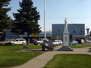
Taber is a town in southern Alberta, Canada that is surrounded by the Municipal District of Taber. It is approximately 51 km (32 mi) east of the City of Lethbridge at the intersection of Highway 3 and Highway 36.

Cardston-Taber-Warner was a provincial electoral district in Alberta, Canada, mandated to return a single member to the Legislative Assembly of Alberta using the first-past-the-post method of voting from 1996 and 2019.

Nordegg is a hamlet in west-central Alberta, Canada within Clearwater County. It is located in the North Saskatchewan River valley in the foothills of the Canadian Rockies, just east of the intersection of the David Thompson Highway and the Highway 734 spur of the Bighorn Highway. A former coal mining town, it was named after Martin Nordegg and the name probably means "North Corner" in a German dialect. The railway station name at the locality was called Brazeau rather than Nordegg at certain points in its history, but the local post office has always been named Nordegg. The name Brazeau is now obsolete.
The Western Canadian Sedimentary Basin (WCSB) underlies 1.4 million square kilometres (540,000 sq mi) of Western Canada including southwestern Manitoba, southern Saskatchewan, Alberta, northeastern British Columbia and the southwest corner of the Northwest Territories. This vast sedimentary basin consists of a massive wedge of sedimentary rock extending from the Rocky Mountains in the west to the Canadian Shield in the east. This wedge is about 6 kilometres (3.7 mi) thick under the Rocky Mountains, but thins to zero at its eastern margins. The WCSB contains one of the world's largest reserves of petroleum and natural gas and supplies much of the North American market, producing more than 450 million cubic metres per day of gas in 2000. It also has huge reserves of coal. Of the provinces and territories within the WCSB, Alberta has most of the oil and gas reserves and almost all of the oil sands.

Mountain Park is a ghost town in western Alberta, south of Cadomin, elevation 6200 feet, at the end of the historic Alberta Coal Branch line of the Canadian National Railway.
Purple Springs is a hamlet in southern Alberta, Canada within the Municipal District of Taber. It is located on Highway 3, approximately 17 kilometres (11 mi) east of Taber.
Enchant is a hamlet in southern Alberta, Canada within the Municipal District of Taber. It is located on Highway 526 and the Canadian Pacific Railway, between Vauxhall and Lomond. It has an elevation of 810 metres (2,660 ft).
The Foremost Formation is a stratigraphic unit of Late Cretaceous (Campanian) age that underlies much of southern Alberta, Canada. It was named for outcrops in Chin Coulee near the town of Foremost and is known primarily for its dinosaur remains and other fossils.
Johnson's Addition is a hamlet in southern Alberta, Canada within the Municipal District of Taber. It is adjacent to the western boundary of the Town of Taber at the intersection of Highway 3 and Highway 864.
The Paul First Nation, more commonly known as the Paul Band, is a First Nations band government based in Wabamun, Alberta of mixed Cree and Nakoda (Stoney) origin. They are party to Treaty Six and had the Buck Lake Indian Reserve 133C and Wabamun Lake Indian Reserve 133A, 133B and 133C allocated to them by the federal government in 1892. However, the Buck Lake Reserve was decimated by the Spanish Flu of 1918 and is now largely abandoned.
The Ardley is a large coal field located in the western part of Canada in Alberta. Ardley represents one of the largest coal reserve in Canada having estimated reserves of 596 billion tonnes of coal.
The Drumheller is a large coal field located in the western part of Canada in Alberta. Drumheller represents one of the largest coal reserve in Canada having estimated reserves of 564 billion tonnes of coal.
The Mannville is a large coal field located in the western part of Canada in Alberta. Mannville represents one of the largest coal reserve in Canada having estimated reserves of 570 billion tonnes of coal.
The MacKay is a large coal field located in the western part of Canada in Alberta. MacKay represents one of the largest coal reserve in Canada having estimated reserves of 403 billion tonnes of coal.
The Lethbridge is a large coal field located in the western part of Canada in Alberta. Lethbridge represents one of the largest coal reserve in Canada having estimated reserves of 277 billion tonnes of coal.
The Daly-Weaver is a large coal field located in the western part of Canada in Alberta. Daly-Weaver represents one of the largest coal reserve in Canada having estimated reserves of 178 billion tonnes of coal.
The Carbon-Thompson is a large coal field located in the western part of Canada in Alberta. Carbon-Thompson represents one of the largest coal reserve in Canada having estimated reserves of 183 billion tonnes of coal.
The Gething is a large coal field located in the western part of Canada in Alberta. Gething represents one of the largest coal reserve in Canada having estimated reserves of 13 billion tonnes of coal.
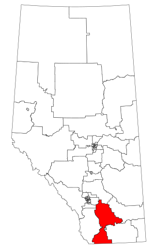
Cardston-Siksika is a new provincial electoral district in Alberta, Canada. The district was one of 87 districts mandated to return a single member (MLA) to the Legislative Assembly of Alberta using the first past the post method of voting. It was contested for the first time in the 2019 Alberta election.
References
- ↑ "Ardley coal deposit" (PDF). alberta.ca. 2012. Retrieved 2013-07-23.
| | This Alberta location article is a stub. You can help Wikipedia by expanding it. |
| | This article about mining is a stub. You can help Wikipedia by expanding it. |